Weather
NJ Weather: Snow Accumulation Estimates Released For Storm
New computer models and data were released that show snow accumulation estimates for New Jersey. Here's the latest.

A low-pressure storm is still expected to present a some kind of a threat to New Jersey this week, with as many as 4 to 6 inches falling in some areas of the state. Enough snow could fall to close schools in a number of a communities, particularly those closest to the Jersey Shore.
A winter storm watch is now in effect for counties along the Jersey Shore, while the rest of the state has been issued a hazardous weather outlook. Read more: NJ Weather: Winter Storm Watch At Jersey Shore
Schools also could be closed, or there could be delayed openings. Read more: New Jersey School Closings/Delays List - 1/4/18
Find out what's happening in Brickfor free with the latest updates from Patch.
Forecasters from the National Weather Service and other agencies have released maps estimating the amount of snow that could fall after 1 a.m. on Thursday. The latest map shows that as many as 3 to 4 inches could fall in Cape May County and eastern Monmouth, Ocean, Burlington and Atlantic counties.
Two to 3 inches could fall in Cumberland, southern Middlesex, western Monmouth, Ocean, Burlington and Atlantic counties. The rest of the state, except for Sussex, Warren and Hunterdon counties, could get 1 to 2 inches.
Find out what's happening in Brickfor free with the latest updates from Patch.

Another model, from NY NJ PA Weather's subscription service, says Central and South Jersey and the Jersey Shore could get 6 to 12 inches, while the rest of the state could get 3 to 6. Wind gusts could be as strong as 20 to 30 mph.
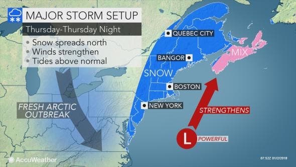
New Jersey is supposed to be clipped by a storm that could produce a blizzard in New England. Read more: NJ Weather: Possible Significant Snowstorm In Forecast
The storm will have both direct and indirect impacts from Florida to Maine and Atlantic Canada, according to AccuWeather. Arctic air will remain in place and will spread southward into Florida as the storm brews nearby over the Atlantic Ocean on Wednesday night and races northward during Thursday and Friday.
The heaviest snow from the storm will fall on Maine and New Brunswick, Canada, where a blizzard is forecast to unfold, according to an AccuWeather release. Some of these same communities may be without power. Tremendous blowing and drifting snow is likely and some communities may be isolated for several days in the wake of the storm.
The storm is likely to track close enough to the coast, however, to throw moisture over land near the coast in the the Southeast and mid-Atlantic states, according to the release. That moisture will be in the form of snow and ice from northeastern Florida to eastern North Carolina.
Motorists and pedestrians should expect at least some blowing and drifting snow as far west as the Hudson Valley of New York, much of New Jersey, the Delmarva Peninsula and even a few areas just inland of the coast in the Southeast states, according to the release. Winds strong enough to trigger airline delays are likely in the major hubs of the Northeast, from Washington, D.C., to Philadelphia, New York City and Boston from Thursday to Friday.
Here is the forecast:
- Tuesday: Sunny, with a high near 24. Wind chill values as low as zero. West wind around 11 mph, with gusts as high as 21 mph.
- Tuesday night: Clear, with a low around 10. West wind 7 to 10 mph.
- Wednesday: Increasing clouds, with a high near 29. Southwest wind around 6 mph becoming light and variable in the afternoon.
- Wednesday night: Snow likely, mainly after 1am. Cloudy, with a low around 20. Light and variable wind becoming north 5 to 10 mph after midnight. Chance of precipitation is 60%. New snow accumulation of around an inch possible.
- Thursday: Snow likely, mainly before 1pm. Cloudy, with a high near 26. Northwest wind 14 to 17 mph. Chance of precipitation is 60%. New snow accumulation of 1 to 2 inches possible.
- Thursday night: A slight chance of snow showers before midnight. Partly cloudy, with a low around 7. Blustery. Chance of precipitation is 20%.
Photo credit: Lanning Taliaferro
Get more local news delivered straight to your inbox. Sign up for free Patch newsletters and alerts.