Weather
NJ Weather: Possible Significant Snowstorm In Forecast
It's still a little early to know what's coming, but a snowstorm could impact New Jersey this week. A hazardous weather outlook was issued.


A significant snowstorm that could produce "near-whiteout" conditions could impact New Jersey this week. Forecasters say the first flakes could come early Thursday morning, after 1 a.m.
The National Weather Service, saying the potential for a plowable snowfall has increased, has issued a hazardous weather outlook since the storm could produce "very gusty northwest winds."
More than an inch is supposed to fall, but snowfall amounts and the severity of impacts will ultimately depend on how close the offshore low-pressure system tracks to New Jersey, which is still uncertain at this time, according to the NWS.
Find out what's happening in Toms Riverfor free with the latest updates from Patch.
Read more: NJ Weather: Snow Accumulation Estimates Released For Midweek Storm

Wind chill advisories will likely be issued late Thursday night into Friday morning and Friday night into Saturday morning, with wind chills falling between 5 below and -10.
Find out what's happening in Toms Riverfor free with the latest updates from Patch.
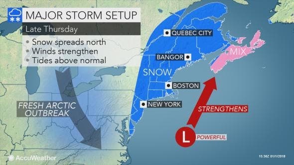
The major storm will track close enough to the East Coast of the United States to bring snow especially in New England, and windy conditions to much of the Atlantic Seaboard later this week, according to an AccuWeather release.
Arctic air will remain in place and will spread southward into Florida as the storm brews a few hundred miles offshore over the Atlantic Ocean and races northward on Wednesday and Thursday.
There is the potential for not only a foot or more of snow to fall in Maine and New Brunswick, but also the risk of hurricane-force winds and frigid air at the same time. Tremendous blowing and drifting snow is likely and some communities could be isolated for several days in the wake of the storm, should this worst-case scenario unfold, according to the release.
Enough snow could make roads slippery in New Jersey, according to the release. If the storm tracks within 100 miles of the coast, heavy snow and difficult travel may occur over the Interstate 95 corridor of the mid-Atlantic. Seas will build to dangerous levels for small craft off the mid-Atlantic, New England and southeastern Canada coasts.
Here is the forecast:
New Year's Day: Mostly sunny, with a high near 18. Wind chill values as low as -6. Northwest wind 14 to 16 mph.
Mondaynight: Partly cloudy, with a low around 10. Wind chill values as low as -6. West wind 11 to 16 mph.
Tuesday: Sunny, with a high near 22. Wind chill values as low as -6. West wind 10 to 17 mph.
Tuesday night: Mostly clear, with a low around 8. West wind 5 to 11 mph.
Wednesday: Mostly sunny, with a high near 31. South wind 3 to 6 mph.
Wednesday night: Snow likely, mainly after 3am. Cloudy, with a low around 20. Chance of precipitation is 70%.
Thursday: Snow likely, mainly before 3pm. Mostly cloudy, with a high near 27. Blustery. Chance of precipitation is 60%.
Thursday night: Partly cloudy, with a low around 6. Blustery.
Friday: Mostly sunny, with a high near 14. Breezy.
Friday night: Partly cloudy, with a low around 2.
Patch file photo
Get more local news delivered straight to your inbox. Sign up for free Patch newsletters and alerts.