Crime & Safety
UPDATE: Travel Bans, NYC Bridges Closed As Blizzard Hits New Jersey
BREAKING: Travel banned widened.

UPDATE: Travel on ALL New Jersey roads banned Monday night. Details.. http://ow.ly/HZwI6
Be careful out there.
The blizzard has blanketed New Jersey, though much of it won’t intensify until later Monday. The largest snow amount has been in Warren County, where nearly two inches have fallen.
Find out what's happening in Brickfor free with the latest updates from Patch.
All Port Authority Bridges and Tunnels will close at 11 p.m. Monday, and PATH service will be shut down, according to the Port Authority.
Already, Hoboken has imposed a vehicular travel ban as of 9 p.m. Vehicular traffic will be restricted only to public safety personnel, medical professionals, mass transit operators and public works and sanitation personnel.
Find out what's happening in Brickfor free with the latest updates from Patch.
New York City Mayor Bill de Blasio also announced that New York City roads will be closed to all non-emergency vehicles starting at 11 p.m. Monday.
PSE&G is reporting 1,554 customers are without power in the northern end of South Brunswick, while the rest of New Jersey has scattered outages.
Also:
- Governor Chris Christie today declared a state of emergency Monday as winter storm with tropic-storm-force winds began to fall in New Jersey.
- NJ Transit will shut own its operations at 8 p.m., and probably will remain closed through Wednesday.
- Newark Liberty International Airport temporarily grounded its operations as the snowstorm hit.
- The Garden State Parkway has a 45-mph speed restriction, as does the entire New Jersey Turnpike.
- The Commodore Barry, Walt Whitman, Betsy Ross and Ben Franklin bridges to Philadelphia all have 35-mph speed restrictions.
- NJ Transit said it would cross-honor bus and rail tickets until it shuts down.
- Emergency management officials throughout the area are watching the storm closely and have road-clearing equipment ready to deploy as the snow starts to fall.
- Airlines flying into and out of the I-95 corridor have already canceled numerous flights; nearly 200 have been canceled at Newark Liberty International Airport in anticipation of the intense storm conditions, and nearly 100 have been canceled at Philadelphia International Airport.
- More than 1,400 flights scheduled for Monday are expected to be canceled, according to the flight tracking site FlightAware. Most major airlines are allowing customers whose flights are canceled in the next few days to book new flights without paying a penalty. Customers ticketed on flights to dozens of Eastern airports are generally eligible for the allowance, though specific terms vary by airline.
- A coastal flood warning is in effect for coastal counties, as the strong northeast winds of 20 to 30 mph accompanying the storm make conditions very favorable for coastal flooding, according to an announcement from Ocean County officials.
- “The impending weather conditions over the course of the afternoon will produce a variety of dangerous travel conditions throughout the state,” said Christie. “I’ve authorized state officials to take all necessary action in advance of the storm, and my administration will continue monitoring conditions throughout the remainder of the storm.”
Snow began to fall in New Brunswick and other places by mid-Monday as New Jersey prepared for the worst.
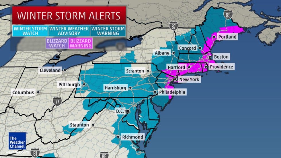
The National Weather Service’s blizzard warning, issued Sunday, remains in effect, with light snow turning heavy beginning at noon today and continuing through 6 p.m. Tuesday, with snowfall rates of 2 to 4 inches per hour and winds gusting to 50 mph as the nor’easter moves up the coast.
Between 6 a.m. and 9 a.m. Tuesday another 6 inches is predicted to fall, before finally easing up Tuesday afternoon.
School distrists throughout the state issue declared plans to dismiss classes early Monday, attempting to get in a half-day of school on the prospect of being closed Tuesday and possibly Wednesday as towns dig out. Some towns also have canceled evening activities for Monday and Tuesday, to encourage residents to stay home as much as possible.
RELATED STORIES:
Counties inland will not be spared completely from the storm; current predictions are for 10 to 18 inches of snow inland.
The warning, which targets the greater New York City metropolitan area includes predictions of heavy snow and blowing snow, which will reduce visibility and make travel extremely dangerous, the National Weather Service says, with whiteout conditions possible. Secondary roads may become impassable.
The strong winds may bring down power lines and tree limbs, the service warns.
Subscribe to the Patch free daily newsletter for more local news, and breaking news alerts delivered to your inbox, by clicking here.
Get more local news delivered straight to your inbox. Sign up for free Patch newsletters and alerts.