Crime & Safety
NWS Releases Storm Details: Foot Of Snow Expected In N.J.
The latest: A nor'easter may dump a foot of snow - or more - in N.J., and sand barriers are being built to stop major coastal flooding.

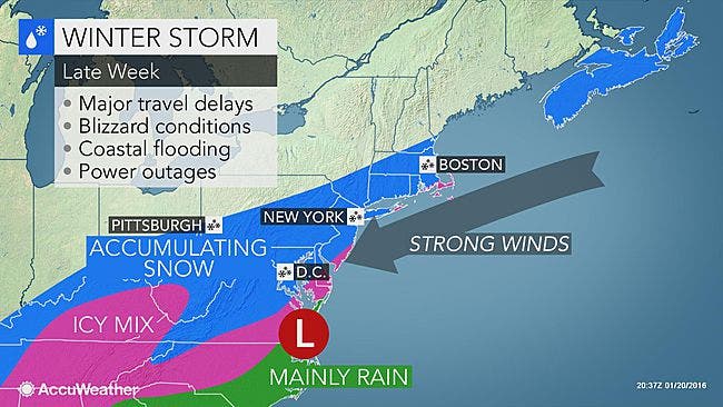
A nor’easter packing up to 60 mph winds is expected to dump a foot of snow - or more - in N.J. this weekend, and sand barriers are being built to stop major coastal flooding.
The National Weather Service has issued a “Blizzard Watch” that will impact almost all of New Jersey from late Friday into Sunday.
Related: BREAKING: Hour-By-Hour Forecast Of Nor’easter Snowstorm In N.J.
Find out what's happening in Brickfor free with the latest updates from Patch.
State and local officials were taking steps to prepare for the winter blast, even building a sand-barrier along the coast to prevent major coast flooding.
The National Weather Service also issued the following details:
Find out what's happening in Brickfor free with the latest updates from Patch.
- Snow accumulations of 12 to 16 inches are expected in the vicinity of the i-95 corridor, while 8 to 12 inches is expected elsewhere.
- The snow is expected to begin Friday evening, primarily after the evening commute, and then continue to be heavy at times into Sunday morning.
- The winds will move northeast at 15 to 25 mph inland with gusts up to 35 mph. Northeast winds of up to 30 to 40 mph, with gusts up to 60 mph, are expected closer to the coast.
- Temperatures are expected to be in the low 30s.
- Impacts: Snow may be dry and puffy at the start, but will become wetter and heavier as the event unfolds. Shoveling may be problematic for those with physical ailments.
- Snow may cling to wires and trees which may cause power outages. Roads will become impassable due to increasing accumulation during the event.
“Right now, it looks like the first high tide to worry about — bringing the risk of major coastal flooding — will be right around sunrise Saturday,” according to Gary Szatkowski NWS meteorologist in Mount Holly, N.J., writing on his blog.
Related: WEATHER UPDATE: Details Released On Nor’easter, ‘Major’ Snowstorm Possible For N.J.
“Winds may be gusting to 60 miles an hour along the Atlantic Coastal beaches of New Jersey and Delaware during the early morning hours on Saturday,” he said. “Anyone venturing outside will have to deal with those wind gusts, including the potential of blowing debris, as well as tree limbs and power lines which may have been brought down.”
“People driving in the dark, along flooded roadways, may find tree limbs and power lines (possibly submerged) along their path. From a societal impacts perspective, some very dangerous conditions may persist.”
Here is a video courtesy of WNBC-TV showing a sand-barrier being built in Belmar:
Get more local news delivered straight to your inbox. Sign up for free Patch newsletters and alerts.