Health & Fitness
A Rinse-and-Repeat Kind of Week
Will there be any breaks from the showers and thunderstorms this week? Find out in this week's PatchCast for July 30th through August 5th.
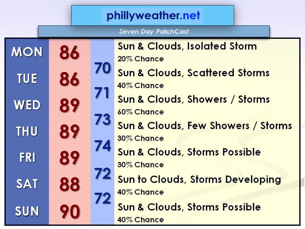
Every day this week will basically be a rinse and repeat of the preceding day. This means that we will see sun, clouds, and thunderstorms this week. While some days have higher storm chances than other days, the possibility is there each day.
I don't think that any particular day will be a wash-out, but the rainiest day will probably be on Wednesday. Monday should end up as the driest day. I should add that it will be humid all week with temperatures between 85 and 90 degrees.
Monday, July 30, will feature a mix of sun and clouds with just a 20 percent chance of a thunderstorm. The best chance of seeing a thunderstorm will be north and west of I-295. Highs will be in the mid-80s.
Find out what's happening in Collingswoodfor free with the latest updates from Patch.
A low-pressure system will make a run at the region on Tuesday, July 31. This will bring us a 40 percent risk of scattered thunderstorms. Otherwise, there will be a mix of sun and clouds with highs in the mid-80s.
That low pressure system will be slow to move away, so there is a higher risk (60 percent) of showers and thunderstorms on Wednesday, August 1. There will probably be more in the way of clouds as well. Highs on Wednesday will be near 90 degrees.
Find out what's happening in Collingswoodfor free with the latest updates from Patch.
A warm front could bring a few showers or thunderstorms to the area on Thursday, August 2. Look for sun and clouds otherwise with highs near 90 degrees.
That front has the possibility of stalling offshore on Friday, August 3. This means showers or thunderstorms will be possible. The high temperature will once again be near 90 degrees.
The stalled front should make a run at the Delaware Valley for the first half of the weekend as a warm front, causing some showers and storms to develop, especially in the afternoon. The high on Saturday, August 4, will be in the upper 80s.
On Sunday, August 5, another area of low pressure will target our region. Look for a mix of sun and clouds with a chance for showers or thunderstorms and a high temperature of 90 degrees.
Keep an eye on Phillyweather.net throughout the week for updates to this forecast!