Health & Fitness
Patch 5-Day Forecast: Cooler Weather This Week
How much cooler will our temperatures be this week? Find out in the PatchCast for January 14-20!
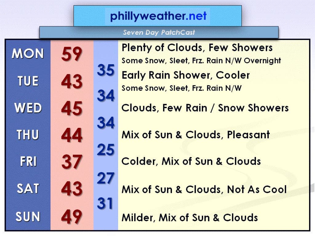
This week will be cooler and a bit stormier than last week. Today will be the last mild day before a return to reality, although temperatures will still remain above the normal high of 40 degrees for most of the week.
A dense fog advisory is in effect until 7 a.m. this morning. Keep it slow on the roads and leave plenty of distance between you and the car in front of you.
Today could end up being the warmest day of this milder stretch of weather. We should end up in the upper 50s for a high before a cold front moves through later on.
Find out what's happening in Collingswoodfor free with the latest updates from Patch.
We'll still see plenty of clouds around like we did all weekend, and there will also be a few rain showers but the day will certainly not be a washout. More showers will move through overnight tonight, and these showers could be in the form of snow, sleet, or freezing rain for areas north and west of I-95. For the rest of us, the precipitation will be plain rain.
Any shower activity will get out of here Tuesday morning, yielding a mostly cloudy and cooler day with a high in the lower half of the 40s. Be sure to watch out for slick spots on the roadways during the morning commute if you'll be traveling in the northwest suburbs of Philadelphia.
Find out what's happening in Collingswoodfor free with the latest updates from Patch.
A weak disturbance passing through on Wednesday could bring a few rain or snow showers to the area, most likely during the first half of the day. Otherwise, expect plenty of clouds and another damp day.
High pressure will take over by Thursday and remain over our region through the weekend. This means the weather will be pretty quiet during this time. By Sunday, we could be dealing with more mild weather with temperatures making a run at 50 degrees.
Be sure to check out Phillyweather.net for updated forecasts!