Health & Fitness
Heat and Humidity to Begin the Week
An excessive heat warning is in effect for the Delaware Valley from noon today (May 28) through 7 p.m. Tuesday (May 29).
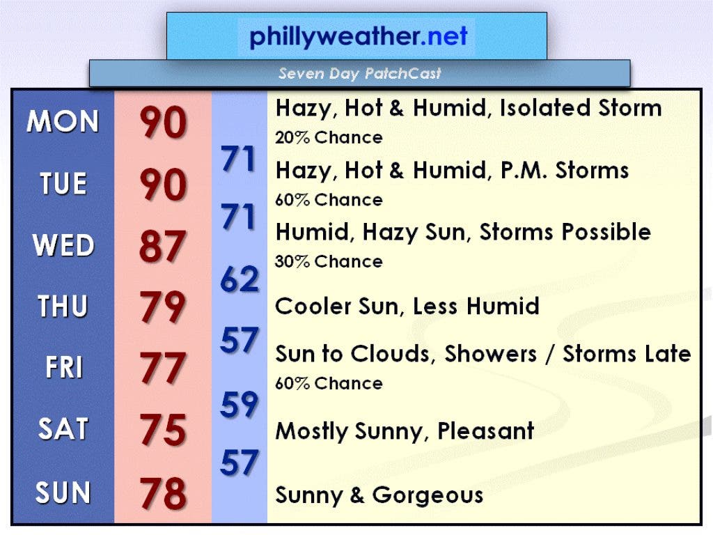
A low-pressure system with its associated warm front moved through the region on Sunday, May 27. Behind the warm front, we will be experiencing hot and humid conditions today and Tuesday. In fact, the National Weather Service has issued an excessive heat warning, effective from noon today through 7 p.m. Tuesday.
High temperatures will be near 90 degrees both days with high levels of humidity, creating heat indices in the mid-90s. In addition, low temperatures will not drop below 70 degrees tonight or Tuesday night. If you have family and friends in the southeast, Tropical Storm Beryl made landfall last night near the Florida-Georgia border and is expected to weaken to a tropical depression later today as it treks across northern Florida and southern Georgia.
Today, May 28, will feature hazy, hot, and humid conditions with just a 20 percent chance of an isolated thunderstorm, so 80 percent of us will be able to get through our Memorial Day barbeques rain-free. The high will be near 90 degrees with a heat index in the mid-90s.
Find out what's happening in Collingswoodfor free with the latest updates from Patch.
Tuesday, May 29, will also be hazy, hot, and humid, but with a disturbance moving over our area aloft, scattered showers and thunderstorms will be developing in the afternoon (60 percent chance). The high on Tuesday will also be near 90 degrees with a heat index in the mid-90s.
A cold front will be passing through on Wednesday, May 30, and has the potential to set off a few thunderstorms (30 percent chance). Otherwise, Wednesday is still humid with hazy sun and a high in the upper 80s.
Find out what's happening in Collingswoodfor free with the latest updates from Patch.
Behind the cold front, Thursday, May 31, looks cooler and less humid with a high only near 80 degrees. A low-pressure system will approach our area on Friday, June 1. This will cause sunshine to give way to increasing clouds with showers and thunderstorms developing late in the day (60 percent chance). Friday's high will be in the upper 70s.
After the low departs, the weekend looks very nice with plenty of sunshine. High in the mid-70s on Saturday, June 2, and in the upper 70s on Sunday, June 3.
Enjoy your Memorial Day and be sure to check in with Phillyweather.net throughout the week!