Health & Fitness
Record Warmth Possible as We Move Into Spring
Spring begins on Tuesday morning at 1:14 a.m. with the vernal equinox.
Another warm week is expected this week, and it looks to be even warmer than last week!
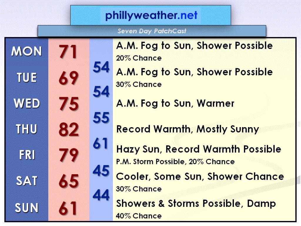
The biggest forecast challenge for the week is the Marine Layer that will likely bring us fog this morning, Tuesday morning, and Wednesday morning, just like it did the past couple of mornings. The Marine Layer is a worse, more widespread version of the sea breezes that the Jersey Shore experiences during the summer. It forms when there is a large temperature difference between the land and the ocean. Ocean temperatures are only around 50 degrees right now, and as the 60 and 70 degree air heats up the land during the day, it causes this Marine Layer to take effect overnight and into the morning hours.
As the morning progresses, the sun mixes the atmosphere and it is able to break through the deck of low clouds and fog. This makes forecasting the high temperature a nightmare because if the fog burns off early, the day could end up a lot warmer than if the fog were to stick around until midday. Due to this Marine Layer, I will keep the forecast high temperature for today (Monday) and Tuesday right around 70 degrees, give or take a couple of degrees on either side.
Find out what's happening in Collingswoodfor free with the latest updates from Patch.
As high pressure positions itself southeast of the Delaware Valley on Wednesday, southerly winds will take over after morning fog burns off. This will cause temperatures to warm into the mid-70s.
Thursday will be the warmest day of the week as another high pressure system develops over the Great Lakes and interacts with the high southeast of the Delaware Valley. A west-southwesterly flow at the surface and aloft will lead to record warmth and temperatures cracking 80 degrees in many locations. The record high for Thursday in Philadelphia is 80 degrees, set back in 1948. This record will likely be broken.
Find out what's happening in Collingswoodfor free with the latest updates from Patch.
Friday, as of now, also looks to feature record warmth. The record high for Friday in Philadelphia is 78 degrees, set back in 1938. This record could also be broken. However, a backdoor cold coming down from our northeast could cause temperatures on Friday to be significantly cooler than the current forecast; it all depends on the timing of this front.
After the front goes through, Saturday and Sunday will be cooler in the lower to mid-60s, which is technically still above average for late March. Sunday could potentially be a showery and damp day if the current forecast from the European computer model holds.
Have a great week everyone, and check in with Phillyweather.net throughout the week for updates to this forecast.