Health & Fitness
Seasonable Temperatures for the First Week of April
After the second warmest March on record, we will be getting back to normal around here, at least for now.
As we move into April, let's take a look back at what happened in March.
March ended up as the second warmest March on record in Philadelphia. The average temperature was 52.2 degrees, which was 8.7 degrees above the average of 43.5 degrees. However, for Allentown, Atlantic City Airport (Pomona), Mount Pocono, Newark and Trenton, it ended up as the warmest March on record.
Moving ahead to this week, it looks rather seasonable for early April. The normal high for this time of year is 59 degrees and the normal low is 39 degrees. We should be very close to these numbers for most of the week.
Find out what's happening in Collingswoodfor free with the latest updates from Patch.
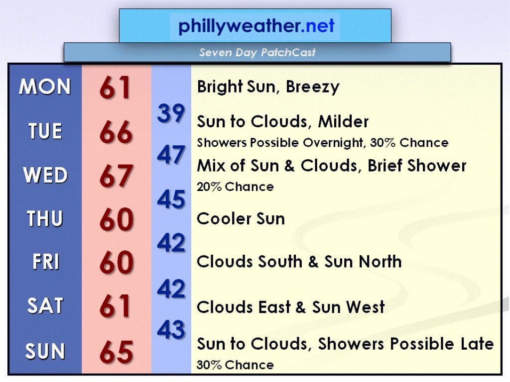
Today, high pressure over the Hudson Bay will interact with low pressure off the coast of the Delmarva Peninsula. This will create a strong pressure gradient, causing today to be a breezy day. Winds will generally be from the north at 15 to 25 mph.
The high temperature will be in the lower 60s. That high pressure system will move southward on Tuesday, causing the day to start with sun, but then clouds will increase as a low pressure system from the Gulf of Mexico moves northeastward and brings us a chance of showers overnight Tuesday night. The high temperature on Tuesday should be milder, in the mid-60s.
Find out what's happening in Collingswoodfor free with the latest updates from Patch.
The low-pressure system departs on Wednesday, but a trough of low pressure in the upper levels of the atmosphere could spawn a brief shower during the day on Wednesday. The high temperature on Wednesday should rise into the upper 60s.
Another high-pressure system will park itself north of the Great Lakes by Thursday, bringing us northerly winds and cooling us down to near 60 degrees. However, it will be a mostly sunny day so it won't feel too bad outside. This high-pressure system will begin to move southward on Friday, and by Saturday it will be sitting over western Pennsylvania.
However, a highly amplified trough of low pressure in the upper levels of the atmosphere will cause a surface low-pressure system to pass by to the south and east of our area on Friday and Saturday. This will cause more clouds to the south and east and more sun to the north and west. However, all of the rain should remain far away from New Jersey and eventually well out into the Atlantic.
High temperatures on Friday and Saturday will be around 60 degrees.
Easter Sunday will warm back up to near 65 degrees, but a passing low pressure system could spawn a few showers late in the day toward dinnertime. It won't be a washout, but have the umbrella handy as you head out to Easter dinner just in case you run into a shower.
Of course, this is still a week away, and things could change by then and it could end up completely dry! Check back in with Phillyweather.net to see how your Easter forecast shapes up as the week progresses.