Health & Fitness
Storms to Sun, Warmth This Week
Downpours are possible Monday and Tuesday before drier weather starts to work its way in.
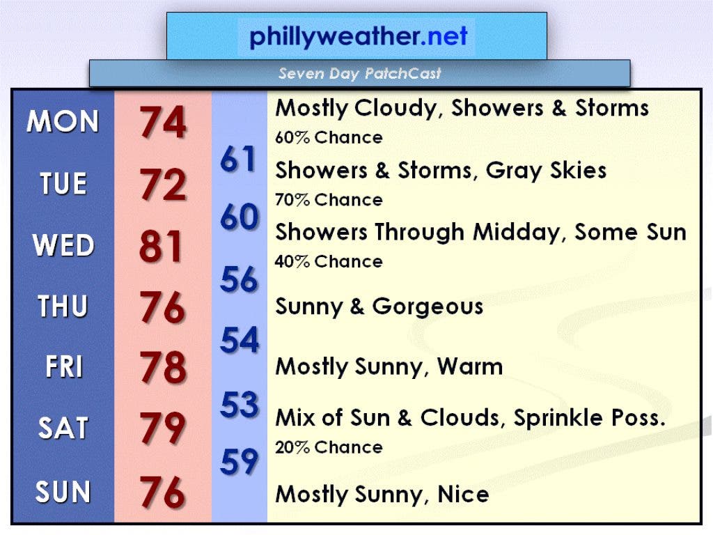
A strong disturbance in the upper levels of the atmosphere along with a cold front at the surface will produce showers and thunderstorms on Monday and Tuesday. Downpours will be possible in these thunderstorms.
On Monday, the high temperature will be in the mid-70s with a 60 percent chance of rain. Some breaks of sun are possible, but skies in general will be mostly cloudy.
On Tuesday, the high temperature will be in the lower 70s with a 70 percent chance of rain. I don't expect to see any breaks in the clouds on Tuesday.
Find out what's happening in Collingswoodfor free with the latest updates from Patch.
On Wednesday, the cold front will finally move off the coast and the showers and thunderstorms will come to an end. By the late afternoon hours, the sun will likely come out and temperatures will warm into the lower 80s.
High pressure starts to build in on Thursday which will dry out the air and clear the skies. Thursday will be an absolutely gorgeous day with sunny skies and a high in the mid-70s.
Find out what's happening in Collingswoodfor free with the latest updates from Patch.
We remain under high pressure on Friday, and Friday will feature mostly sunny skies with a high in the upper 70s. As high pressure moves offshore for the weekend, Saturday will likely have a few extra clouds around with a slight chance of a sprinkle. The high temperature on Saturday will be in the upper 70s.
Another high pressure system moves over the area on Sunday, and Sunday will be a mostly sunny and nice day with a high in the mid-70s.
Be sure to check in with Phillyweather.net throughout the week for updated forecasts. Have a great week!