Health & Fitness
A Week Later, Thunderstorms Still Likely
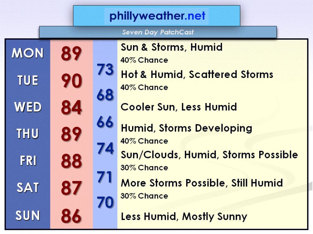
Those thunderstorms that threatened our area last week might be in the cards again this week, according to Brian Donegan's PatchCast.
Those of you who dodged the rain last week will have plenty more opportunities upcoming, as there is a chance of thunderstorms four of the five work days of this week. Wednesday should be the exception, with plenty of sunshine and low humidity. Hopefully by the end of this upcoming weekend, we will start to dry out.
A weak disturbance moving through the Delaware Valley will cause a changeable day Monday, July 23. We will see intervals of sun with thunderstorms possible in between. Not everyone will get wet but the chance is about 40 percent. Otherwise, it will be humid with a high in the upper 80s this afternoon.
Tuesday, July 24, will be the hottest day of the week in advance of a cold front that will move through at night. There will likely be scattered thunderstorms that develop ahead of the front, but once again not everyone will get wet (40 percent chance). Tuesday's high will be near 90 degrees with quite a bit of humidity.
Find out what's happening in Collingswoodfor free with the latest updates from Patch.
Behind the cold front Wednesday, July 25, will be cooler and less humid air. Temperatures will hold in the lower to mid-80s with mostly sunny skies.
A warm front will make a run at the region Thursday, July 26, increasing temperatures and humidity again. The warm and humid airmass should cause some thunderstorms to pop up (40 percent chance). The high will be in the upper 80s.
Find out what's happening in Collingswoodfor free with the latest updates from Patch.
The warm and humid airmass will remain over the area for Friday, July 27. Expect a mix of sun and clouds with a 30 percent chance of thunderstorms. The high will be in the upper 80s.
Another cold front will approach Saturday, July 28, so it will remain humid and more thunderstorms will be possible (30 percent chance). The high will be in the mid to upper 80s.
Behind Saturday's cold front will be less humid weather for the second half of the weekend. Sunday, July 29, looks mostly sunny and less humid with a high in the mid-80s, which is seasonable for this time of year.
Have a wonderful week, and check in with Phillyweather.net everyday for daycasts in the morning and full forecasts in the afternoon!