Health & Fitness
Unsettled with Below Normal Temperatures This Week
Temperatures should be around 80 degrees in early June. We will be below this number throughout the work week.
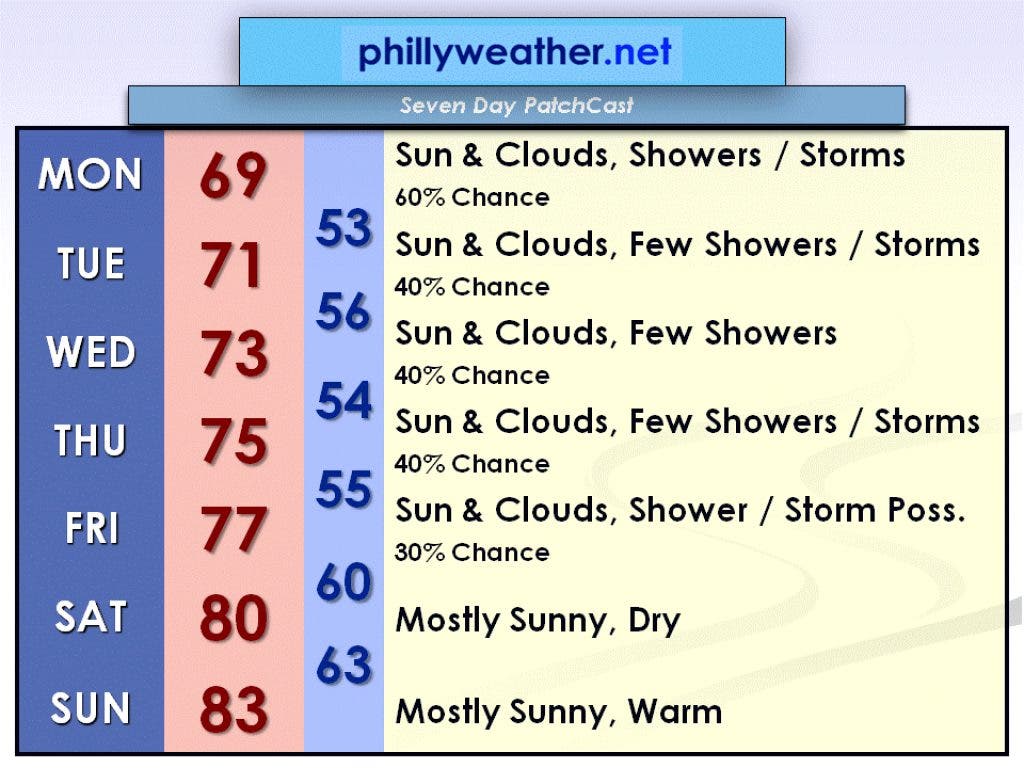
An upper level low will move eastward across our region today, June 4th. This will cause showers and thunderstorms to develop and create a damp day in the Delaware Valley. There should be some breaks in the clouds, but temperatures will likely hold in the upper 60s.
After this upper level low moves off the coast tonight, a mid-level low will influence our weather for the remainder of the work week. A few showers and thunderstorms are expected for Tuesday, June 5th, with some sunny breaks. The high temperature will be around 70 degrees. On Wednesday, June 6th, look for a few more showers with a high temperature in the lower 70s.
As we move into the latter part of the work week, we remain beneath the mid-level low. Expect a few showers and thunderstorms on Thursday, June 7th, with some breaks of sun. The high temperature will be near 75 degrees. By Friday, June 8th, the rain chance diminishes and there is just a slight chance of a shower or thunderstorms. Otherwise, there will be a mix of sun and clouds with a high temperature in the mid to upper 70s.
Find out what's happening in Collingswoodfor free with the latest updates from Patch.
High pressure will try to work its way into the area by the weekend, and I'll be optimistic and forecast that it will. If this is the case, the weekend will be mostly sunny and dry. Temperatures will be seasonable on Saturday, June 9th, with a high near 80 degrees. Sunday, June 10th, looks warm with a high in the lower 80s.
The current unsettled pattern we are in is subject to change, so be sure to check Phillyweather.net daily for updated forecasts. Have a great week!