Health & Fitness
Warm Start, Cool Finish to the Week
How much longer will this warm weather last? Find out in the PatchCast for March 11-17.
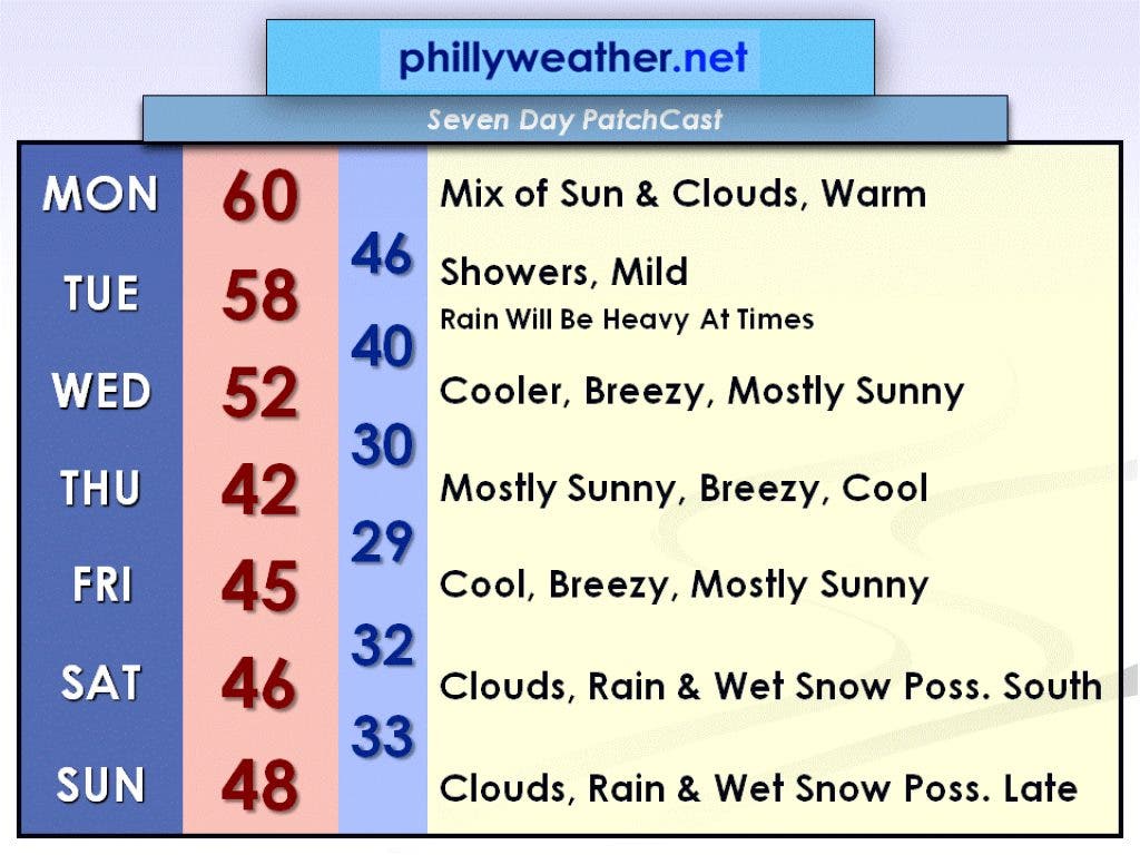
With a warm southerly breeze Monday, we should warm up to near 60 degrees again! There will be more in the way of clouds, especially later in the day, but we will still see some sun. Clouds will thicken tonight as a cold front approaches the Delaware Valley from the west, bringing along some rain for Tuesday.
It looks like rain showers will begin around daybreak Tuesday morning. Some of these showers could pack a punch with quite heavy rainfall, so you definitely want to be prepared with an umbrella. On the plus side, at least temperatures will still be mild, in the upper 50s.
Behind the cold front will be cooler weather for the rest of the week. Wednesday will be the first step down in the temperature department, into the low 50s. It will be mostly sunny but breezy, so it'll feel more like the low 40s.
Find out what's happening in Collingswoodfor free with the latest updates from Patch.
Thursday will be the second step down, even further, into the low 40s. Combine that with the breeze again and it'll feel like the low 30s. Temperatures will recover a few degrees on Friday but with breezes continuing.
Our next chances for precipitation will be Saturday and Sunday. Expect a mostly cloudy day on Saturday with rain and wet snow possible, but the best chance of this will be across far southern New Jersey and southern Delaware.
Find out what's happening in Collingswoodfor free with the latest updates from Patch.
Sunday (St. Patrick's Day) will be another mostly cloudy day with another chance for rain or wet snow—this time, across anywhere in the Delaware Valley but not until late in the day or at night.
The weekend won't be a wash-out by any means, but keep an eye on our forecasts at Phillyweather.net as things could change as the weekend inches closer.