Health & Fitness
Windy to Start the Week, Then Turning Cooler
A red flag warning is in effect from 10 A.M. to 8 P.M. today.
The biggest story of today will be the wind. A red flag warning is in effect from 10 a.m. to 8 p.m. due to strong, gusty winds interacting with very dry air. Therefore, the potential exists for a rapid spread of forest fires if they were to develop.
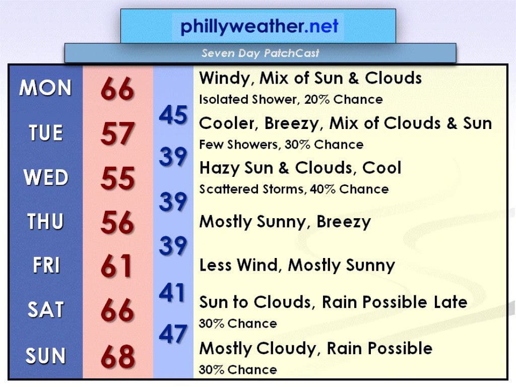
Flipping through the channels on Saturday afternoon, I saw The Weather Channel had a breaking news story on a fire that formed in the Pine Barrens in New Jersey. If you live near a wooded area, just be on the lookout for any signs of fires. Otherwise, a mix of sun and clouds is expected today with just a 20 percent chance of an isolated shower. Winds will be out of the west at 15 to 25 mph with gusts to 40 mph. The high temperature today will be in the mid-60s.
Today's strong winds are being caused by a strong low pressure system sitting over New Brunswick, Canada, just to the northeast of Maine. This low pressure system will remain nearly stationary through Tuesday, causing Tuesday to be another breezy day. Winds will not be as strong tomorrow as they will be today, but gusts will still approach 30 mph by Tuesday afternoon. A mix of clouds and sun is expected on Tuesday with a 30 percent chance of a few showers. It will be cooler with a high in the upper 50s.
Find out what's happening in Collingswoodfor free with the latest updates from Patch.
A disturbance on Wednesday afternoon could cause some thunderstorms to develop. Wednesday will be the coolest day of the week with a high only around 55 degrees. Clouds will mix with hazy sun. As we move into Thursday, high pressure takes over and the skies brighten back up. It remains cool and breezy, however, with a high in the mid-50s. We remain under high pressure for Friday and the winds diminish. Friday will be a touch warmer, in the lower 60s, under mostly sunny skies.
There is some uncertainty for the weekend. A low pressure system will pass by to our north and could bring us some rain by late in the day Saturday, lasting into Sunday. If the low pressure system takes a track farther to the north, it could be dry all weekend, but if it takes a more southern track, we could end up rainy and damp. It should be a mild weekend though with highs in the mid to upper 60s. Check in with Phillyweather.net throughout the week for daily updates to this forecast.