Weather
3 Tornado Touchdowns Confirmed In NJ, Storm Surveys Show
Three tornadoes have been confirmed in New Jersey following Tuesday's storms.


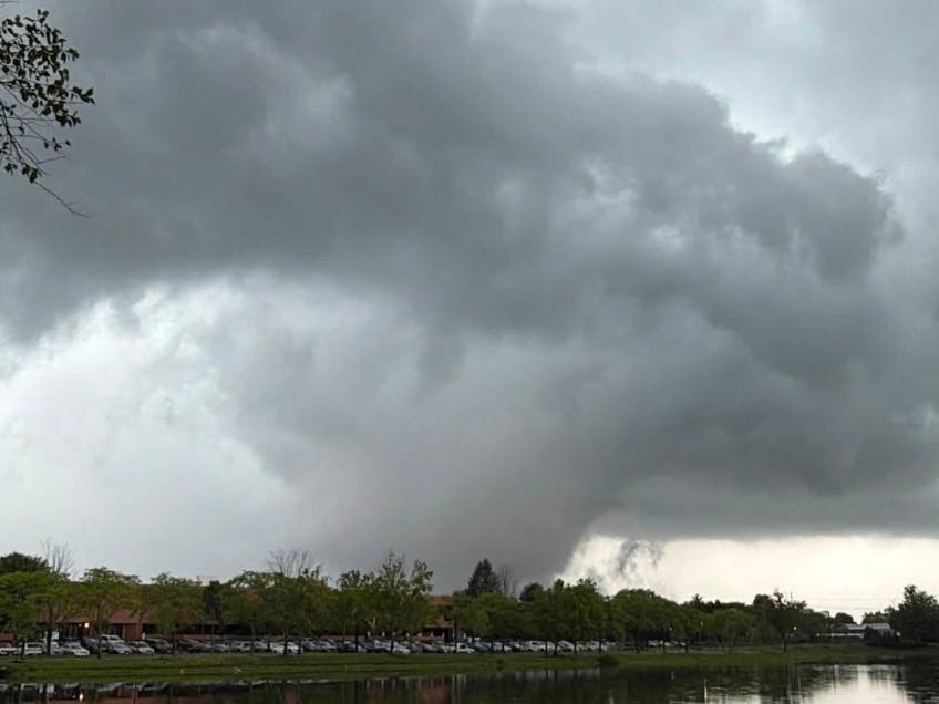
The National Weather Service’s storm surveys have confirmed that New Jersey was hit by three tornadoes in the span of a few hours on Tuesday.
On Tuesday morning, the National Weather Service (NWS) issued a tornado warning for Bergen, Cape May, Essex, Morris, Passaic, and Somerset counties. Most counties in New Jersey remained under a tornado watch until 9 p.m. Tuesday, with Central Jersey watches being lifted around 7 p.m.
Find out what's happening in Englewood-Englewood Cliffsfor free with the latest updates from Patch.
Amid those warnings, two tornadoes were reported in North Jersey, and one was reported in the south.
The storms prompted the NWS to conduct storm surveys on Wednesday, which analyze the power of the tornado and the damage it caused. The NWS uses the Enhanced Fujita Scale, or EF Scale, to classify twisters into the following categories:
Find out what's happening in Englewood-Englewood Cliffsfor free with the latest updates from Patch.
- EF-0: 65 to 85 mph
- EF-1: 86 to 110 mph
- EF-2: 111 to 135 mph
- EF-3: 136 to 165 mph
- EF-4: 166 to 200 mph
- EF-5: >200 mph
Stanhope Twister
The NWS says that a "trained spotter" witnessed the first tornado touching down at the intersection of Interstate 80 and US Route 206 in Stanhope at 3:10 p.m.
Footage posted on social media shows trees, branches, and power lines sprawled across I-80 in the wake of the weather phenomenon.
Details on the tornado's strength and the damage it caused will be made available later Wednesday evening.
Pinebrook Twister
Shortly after, around 3:43 p.m., the NWS was sent video of a tornado seeming to have touched down in Montville (see above photo).
The Montville twister was confirmed on Wednesday evening. Details on the tornado's strength and the damage it caused will be made available later Wednesday evening.
Cape May Point Twister
A waterspout was spotted off the coast of Cape May Point around 6:13 p.m. It came towards the coast, becoming a tornado. ABC Action News acquired footage of the spout before it became a tornado.
The NWS conducted a virtual survey of the Cape May Point twister, and determined that its winds peaked between 60 and 70 mph, an EF-0.
“A narrow path of tree damage was noted along Lincoln Avenue, Yale Avenue, and near the intersection of Oxford Avenue and West Lake Drive,” the survey reads. “At least one witness saw the funnel cloud proceed into Lake Lily.”
Cape May Point’s twister traveled .3 miles and had a maximum width of 30 yards, experts say. Once the spout jumped to land, becoming a tornado, it lasted about a minute before dissipating.
____
No major injuries have been reported following the intense weather as of yet, but the storms did seem to cause quite a bit of damage to property and infrastructure.
According to state weather officials, tornadoes in New Jersey are usually relatively weak and short-lived. Experts say the Garden State experiences about two tornadoes per year.
With potentially three tornadoes under our belt in just a few hours, and a string of intense weather preceding them, it's hard to say what to expect for the rest of the season.
Tornado season in New Jersey is generally March through October, though tornadoes can occur at any time of the year. Over 80 percent of all tornadoes strike between noon and midnight, experts say.
Check back with Patch as the NWS's storm surveys come in.
Get more local news delivered straight to your inbox. Sign up for free Patch newsletters and alerts.