Crime & Safety
UPDATE: Hurricane Joaquin Strengthens To Cat 4, Could Strike N.J.
The storm strengthened to a Category 4 storm, packing 130 mph winds, with expected landfall by Monday.

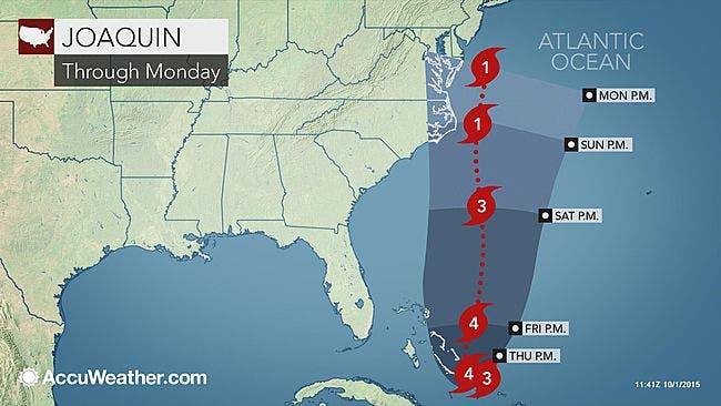
Hurricane Joaquin has strengthened to a Category 4 storm, packing 130 mph winds, and forecasters now say the “major” storm could hit New Jersey.
The National Hurricane Center, however, now has a model that shows the hurricane veering to the east. All these models have been subject to change by the hour.
The center said the Category 4 storm is moving generally southwestward at about 6 mph, and a southwestward or westward motion is expected to continue through Thursday night.
Find out what's happening in Gallowayfor free with the latest updates from Patch.
A turn toward the northwest and north is expected on Friday, and a faster motion toward the north is expected Friday night and Saturday. On the forecast track, the center of Joaquin will move near or over portions of the central Bahamas Thursday and tonight and pass near or over portions of the northwestern Bahamas.
A Category 4 hurricane usually packs winds ranging from 131 to 155 mph and can cause severe damage, long-term power outages and long-lasting water shortages.
Find out what's happening in Gallowayfor free with the latest updates from Patch.
BREAKING: Christie Declares State Of Emergency As Hurricane Joaquin Approaches
“Joaquin will move northward much of this weekend, roughly paralleling the East Coast. There is nearly equal possibility the storm will make landfall along the mid-Atlantic coast, the New England coast or veer out to sea,” according AccuWeather.com.
Get updates on the hurricane by signing up for a Patch newsletter - click here for more
As of 5 a.m., forecasters from The National Weather Service and The Weather Channel reported:
- Hurricane Joaquin’s center was located about 65 miles southeast of San Salvador in the central Bahamas early Thursday.
- This system is moving slowly to the west-southwest and this is expected to continue through Thursday before turning north Friday into Saturday.
Hurricane Joaquin could have the following impacts on the New Jersey area:
- The storm could bring pounding surf, dangerous seas, strong winds, drenching squalls and flash flooding to the East Coast and the Bahamas, according to AccuWeather.com.
- The Weather Channel described the storm’s potential impact in one word: “massive.”
- All weather models indicate that at least five inches of rain could fall in the area by Monday.
- The National Weather Service has issued a Hazardous Weather Outlook and a Coastal Flood Warning for New Jersey, saying the storm - even it pushes west, or away from the coast - will likely cause flooding problems at the shoreline.
- Rip current, small craft and gale advisories were posted for Thursday as a separate weather system passes through.
- Once Hurricane Joaquin moves north, it will bring with it an elevated risk of rip currents along the coast, and the week’s rain may result in localized flooding in areas of poor drainage.
The National Hurricane Center and The Weather Channel said the storm’s impacts could reach the New Jersey-Pennsylvania region by late Sunday or early Monday morning.
To reach hurricane status, wind speeds need to hit a sustained 74 miles per hour.
RELATED:
Get more local news delivered straight to your inbox. Sign up for free Patch newsletters and alerts.