Weather
2 Tornadoes ID'd In NJ This Week As More Bad Weather Possible
The storms that hit this week were worse than originally thought, and more bad weather is possible in New Jersey.


Looks like the storms that hit parts of New Jersey this week were worse than originally thought. And more bad weather could wash out Father's Day and beyond (see forecast below).
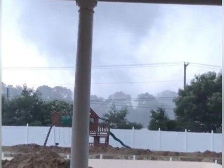
The National Weather Service confirmed this weekend that two tornadoes actually hit New Jersey this week – with one of them traveling a long path that carried it to several communities.
Here were the two tornadoes that touched down on Thursday:
Find out what's happening in Gloucester Townshipfor free with the latest updates from Patch.
- One tornado took a non-continuous path from Deptford Township into the Blackwood section of Gloucester Township. There were several locations of tree damage, including snapped and uprooted hardwood trees, according to the National Weather Service. There was damage to three residences in Deptford Township when portions of trees fell on these homes. In Blackwood, an uprooted tree caused damage to an apartment building.
Closer look of storm damage on Erial Blenheim Road. #GTPD pic.twitter.com/B5G3FzdRbg
— GloucesterTwpPolice (@GloTwpPolice) June 14, 2019 - Another tornado formed in a development near Saddle Court in Mullica Hill. This caused damage to fencing at one residence, and ripped a gutter off another residence. Backyard furniture was lifted approximately 50 yards. From there, the tornado moved in a northeasterly direction and caused a narrow path of tree damage before lifting southwest of U.S. 322.
Read more: Tornado Confirmed In NJ, And Videos Show It (UPDATED)
Find out what's happening in Gloucester Townshipfor free with the latest updates from Patch.
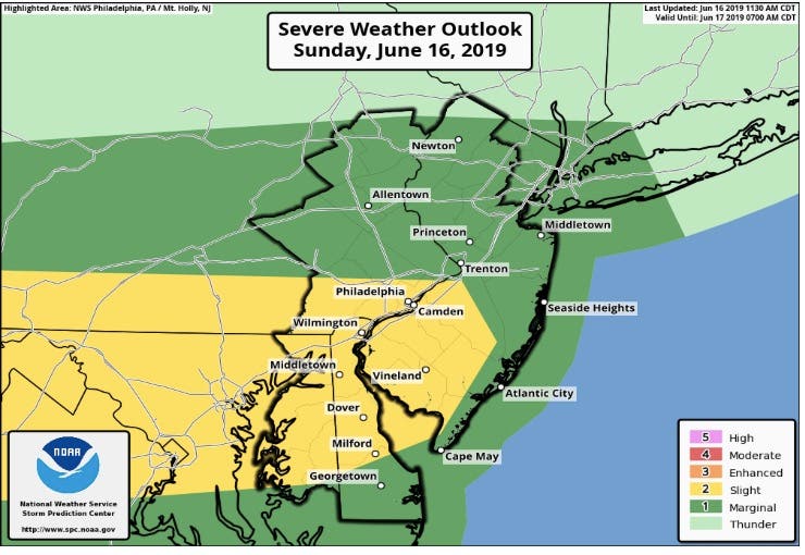
The NWS, meanwhile, has issued a hazardous weather outlook for nearly all of New Jersey, saying there is a chance for severe weather across the state on Father's Day. Damaging winds and large hail are the main threats.
Several chances of showers and storms exist through Thursday. There is potential for severe storms Monday and flooding may become more of a problem with time across the area should repeated rounds of storms arrive.
Much of the worst weather is expected to hit in South Jersey – right where the tornadoes did damage on Thursday:
Here is the forecast:
- Father's Day afternoon: A chance of showers and thunderstorms. Cloudy, with a high near 82. Southwest wind 11 to 14 mph, with gusts as high as 26 mph. Chance of precipitation is 50%. New rainfall amounts of less than a tenth of an inch, except higher amounts possible in thunderstorms.
- Father's Day night: Showers and thunderstorms likely before 5am, then a chance of showers. Cloudy, with a low around 65. West wind 5 to 9 mph. Chance of precipitation is 60%. New rainfall amounts between a tenth and quarter of an inch, except higher amounts possible in thunderstorms.
- Monday: A slight chance of showers, then a chance of showers and thunderstorms after 2pm. Mostly cloudy, with a high near 82. Light and variable wind. Chance of precipitation is 40%. New rainfall amounts of less than a tenth of an inch, except higher amounts possible in thunderstorms.
- Monday night: A chance of showers and thunderstorms, then showers likely and possibly a thunderstorm after 8pm. Cloudy, with a low around 66. Calm wind. Chance of precipitation is 70%. New rainfall amounts between a tenth and quarter of an inch, except higher amounts possible in thunderstorms.
- Tuesday: A chance of showers and thunderstorms. Mostly cloudy, with a high near 82. Light west wind. Chance of precipitation is 50%. New rainfall amounts between a quarter and half of an inch possible.
- Tuesday night: A chance of showers and thunderstorms. Mostly cloudy, with a low around 63. Chance of precipitation is 50%. New rainfall amounts between a quarter and half of an inch possible.
- Wednesday: A chance of showers, then showers likely and possibly a thunderstorm after 2pm. Mostly cloudy, with a high near 80. Chance of precipitation is 60%.
- Wednesday night: Showers likely and possibly a thunderstorm before 8pm, then a chance of showers. Mostly cloudy, with a low around 65. Chance of precipitation is 60%.
- Thursday: A chance of showers, with thunderstorms also possible after 2pm. Mostly cloudy, with a high near 81. Chance of precipitation is 50%.
- Thursday night: A chance of showers and thunderstorms. Mostly cloudy, with a low around 65. Chance of precipitation is 50%.
- Friday: A chance of showers. Partly sunny, with a high near 81. Chance of precipitation is 30%.
Get more local news delivered straight to your inbox. Sign up for free Patch newsletters and alerts.