Weather
'Black Ice' Alert For New Jersey: School Closings, Hazardous Weather Outlook
A black ice alert was issued for New Jersey as temperatures dropped sharply following the snowstorm. Some schools have already canceled.


A black ice alert was issued for New Jersey Thursday night, a day after between 2 and 11 inches of snow fell across the state and temperatures dropped sharply.
Some schools have already canceled for Friday as the state deals with the after-effects of the snowstorm. The National Weather Service issued a hazardous weather outlook as temperatures could drop as low as 15 degrees.
Find out what's happening in Gloucester Townshipfor free with the latest updates from Patch.
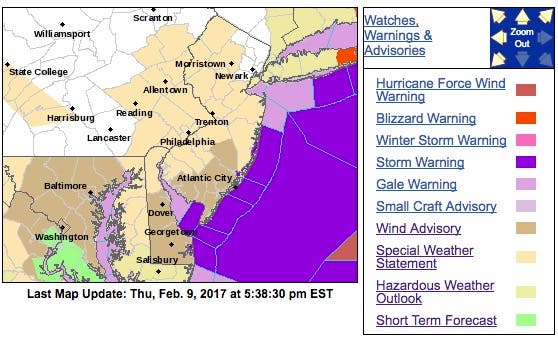
The NWS alert, entitled "BLACK ICE POSSIBLE ON AREA ROADS OVERNIGHT," says that many roads, sidewalks and other surfaces remain wet from the wintry precipitation that fell earlier today. Temperatures are expected to fall into the teens and 20s tonight.
As a result, black ice will be possible, especially on untreated roads and sidewalks.
Find out what's happening in Gloucester Townshipfor free with the latest updates from Patch.
"Use caution if traveling tonight," according to the alert. "Secondary roads, bridges, and overpasses are the most prone to becoming icy. Reduce speed and keep a safe following distance when driving in case you encounter icy conditions."
Sarah Johnson, a NWS meteorologist, said her office "is concerned" about black ice because of the standing water left over from the recent rain and warm weather.
Now that's all going to freeze up, she said.
Here is the forecast:
- Thursday night: Mostly clear, with a low around 15. Blustery, with a west wind 17 to 22 mph decreasing to 10 to 15 mph after midnight.
- Friday: Increasing clouds, with a high near 31. West wind 10 to 15 mph.
- Friday night: A chance of snow, mainly before 1am. Cloudy, with a low around 25. South wind around 7 mph. Chance of precipitation is 30%. Little or no snow accumulation expected.
- Saturday: Mostly cloudy, with a high near 50. Southwest wind 6 to 8 mph.
- Saturday night: A chance of rain, mainly after 1am. Cloudy, with a low around 37. West wind around 6 mph becoming calm in the evening. Chance of precipitation is 30%. New precipitation amounts of less than a tenth of an inch possible.
- Sunday: Rain likely. Cloudy, with a high near 45. Chance of precipitation is 60%. New precipitation amounts between a tenth and quarter of an inch possible.
Patch file photo
Get more local news delivered straight to your inbox. Sign up for free Patch newsletters and alerts.