Weather
N.J. Weekend Forecast Updated As Hazardous Weather Heads Toward Region
Forecasters have modified their weekend forecast predictions as hazardous weather is expected for next week.


Looks like that drive to the Super Bowl Sunday party won't be so messy after all. Good thing it won't be played later in the week, however.
Forecasters have modified their weekend forecast predictions for New Jersey this weekend, but they still expect hazardous weather to arrive next week.
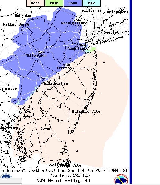
Parts of northern New Jersey could have some light snow on Sunday, but the weather that day is expected to be mostly clear, according to the National Weather Service and The Weather Channel.
Find out what's happening in Gloucester Townshipfor free with the latest updates from Patch.
AccuWeather said a "few snow showers" could finish out the weekend, and could have some impact on the Monday commute. But the system will be "weak."
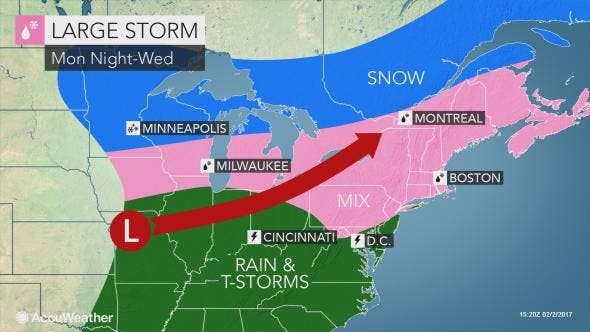
A "significant," severe pattern of storms, meanwhile, remains on track to arrive New Jersey as early as Monday, and it could make the area a snowy, rainy and slushy mess.
Find out what's happening in Gloucester Townshipfor free with the latest updates from Patch.
Forecasters won't call it a nor'easter, but the weather pattern hitting New Jersey on Monday could have the same elements as the damaging system and churn throughout the state until Wednesday.
Those elements include: strong winds, heavy rains, thunderstorms and snow. This system is expected to follow a smaller, less significant snowfall that's supposed to hit on Super Bowl Sunday.
Read more: Large Storm In New Jersey Forecast Early Next Week
Here is a map provided by AccuWeather:
The National Weather Service said it may issue an alert by Sunday. The agency has issued forecasts showing that snow and a wintry mix could arrive on Monday night and Tuesday, and could lead to school closings and delays.

Here is the forecast:
- Friday afternoon: Mostly cloudy, with a high near 36. West wind 9 to 14 mph.
- Friday night: Mostly cloudy, then gradually becoming mostly clear, with a low around 18. Northwest wind 11 to 14 mph.
- Saturday: Sunny, with a high near 34. West wind 9 to 11 mph.
- Saturday night: Increasing clouds, with a low around 23. Southwest wind 3 to 7 mph.
- Sunday: slight chance of snow showers before 11am, then a slight chance of rain showers. Mostly cloudy, with a high near 41. Southwest wind 7 to 13 mph. Chance of precipitation is 20%.
- Sunday night: Partly cloudy, with a low around 31.
- Monday: Mostly sunny, with a high near 43.
- Monday night: A chance of rain before midnight, then a chance of rain and snow between midnight and 2am, then a chance of snow after 2am. Mostly cloudy, with a low around 30. Chance of precipitation is 40%.
- Tuesday: A chance of snow before 8am, then a chance of rain and snow between 8am and 9am, then a chance of rain after 9am. Cloudy, with a high near 45. Chance of precipitation is 50%.
- Tuesday night: A chance of rain. Cloudy, with a low around 40. Chance of precipitation is 50%.
- Wednesday: A chance of rain. Mostly cloudy, with a high near 53. Chance of precipitation is 50%.
Patch file photo
Get more local news delivered straight to your inbox. Sign up for free Patch newsletters and alerts.