Weather
Flash Flood Watch Issued From Saturday To Sunday In Hoboken Area
There won't be as much rain as during Tropical Storm Elsa, but the NWS issued a flash flood watch in Hudson County. Find out when it starts.

HOBOKEN, NJ — The National Weather Service has issued a flood watch for Hoboken and Hudson County starting at 2 p.m. Saturday and ending at 6 a.m. Sunday. READ MORE: Severe Storms Loom In Parts Of NJ As Heat Index Soars Over 100
High tide in Hoboken will occur within the watch period at 3:10 p.m. on Saturday and 3:18 a.m. Sunday.
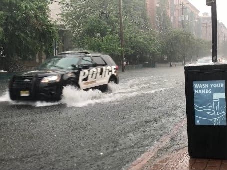
Hoboken experienced flash floods on two recent occasions this month. READ MORE: Flash Flood Traps Shoppers In Hoboken Lot
Find out what's happening in Hobokenfor free with the latest updates from Patch.
The Hudson County Office Of Emergency Management also sent out a heat advisory that remains in effect until 8 p.m. Saturday. "Seniors and those with chronic health problems or mental health conditions are at an increased risk," they noted. "Check on vulnerable friends, family members and neighbors... Heat stroke is an emergency! In cases of heat stroke call 911."
The National Weather Service issued this flood watch for the Hoboken area:
Find out what's happening in Hobokenfor free with the latest updates from Patch.
The National Weather Service in Upton has issued a flash flood watch for portions of southern Connecticut, northeast New Jersey and southeast New York, including the following [New Jersey] areas: Eastern Bergen, Eastern Essex, Eastern Passaic, Eastern Union, Hudson County, Western Bergen, Western Essex, Western Passaic and Western Union.
Showers and thunderstorms are expected to impact the area ahead of a slow moving cold front. The rain will fall across areas with abnormally wet antecedent conditions due to recent heavy rain, leading to an increased potential for flash flooding. You should monitor later forecasts and be prepared to take action should Flash Flood Warnings be issued.
More Information
Turn around; don't drown when encountering flooded roads. Flash floods have proved fatal to drivers (sometimes trapping parents and children) and people near even small streams.
Here is the National Weather Service forecast: click here to get the most up-to-date forecast
Do not drive around barricades.
Intersections that sometimes flood in Hoboken include:
- 1st and Marshall
- 1st and Harrison
- 2nd and Harrison
- 3rd and Harrison
- 4th and Harrison
- 4th and Monroe
- 3rd and Jackson
- 4th and Jackson
- 9th and Monroe
- 9th and Madison
- 10th and Madison
- 1st and Clinton
- 3rd and Clinton
- Henderson and Newark
- Grove and Newark
Report flooded intersections and clogged drain inlets by calling the NHSA Hotline at 866-689-3970.
More Information From The City
- Review the Hoboken Ready website and flyer available in English and Spanish.
- Learn how Hoboken and NHSA prepare for, respond to, and recover from intense rainfall storms.
- Learn about Hoboken's efforts to mitigate rainfall flooding.
Want updates on important events like this, when they happen? You can sign up for occasional breaking news alerts in Hoboken, and for a daily newsletter at 6 a.m. each morning with Hoboken news. Don't miss the stories your neighbors are talking about! Sign up with your preferences here.
Got news? Email caren.lissner@patch.com. Got photos? Please include express written permission from the photographer for us to use them. To be the first to get free news alerts with breaking stories in your town, or to get a free local newsletter each morning, sign up for Patch breaking news alerts or daily newsletters.
Get more local news delivered straight to your inbox. Sign up for free Patch newsletters and alerts.


