Weather
Flash Floods Pop Up Around Hoboken Again: Hurricane Henri Update
The flood watch for Hoboken now runs through Monday night. "Residents are reminded to stay home and not travel," the city said Sunday.

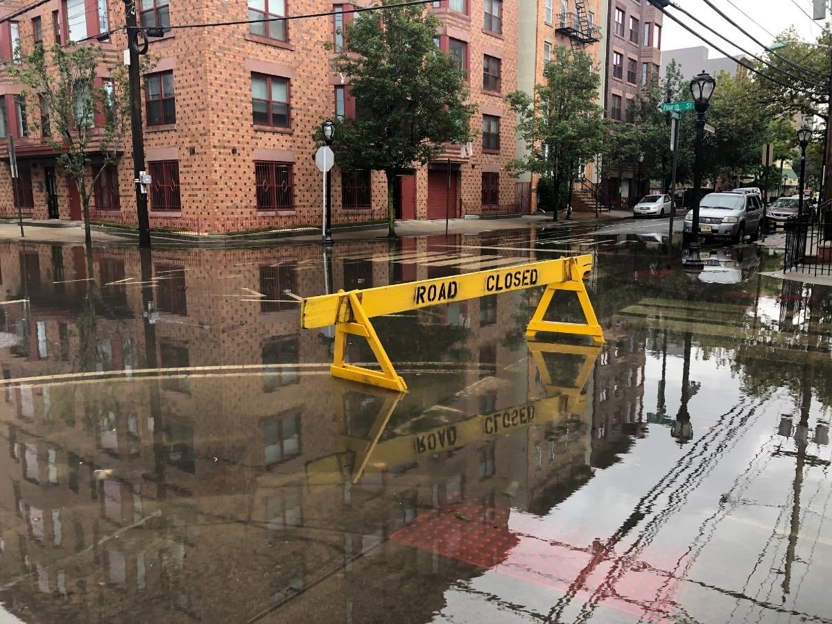
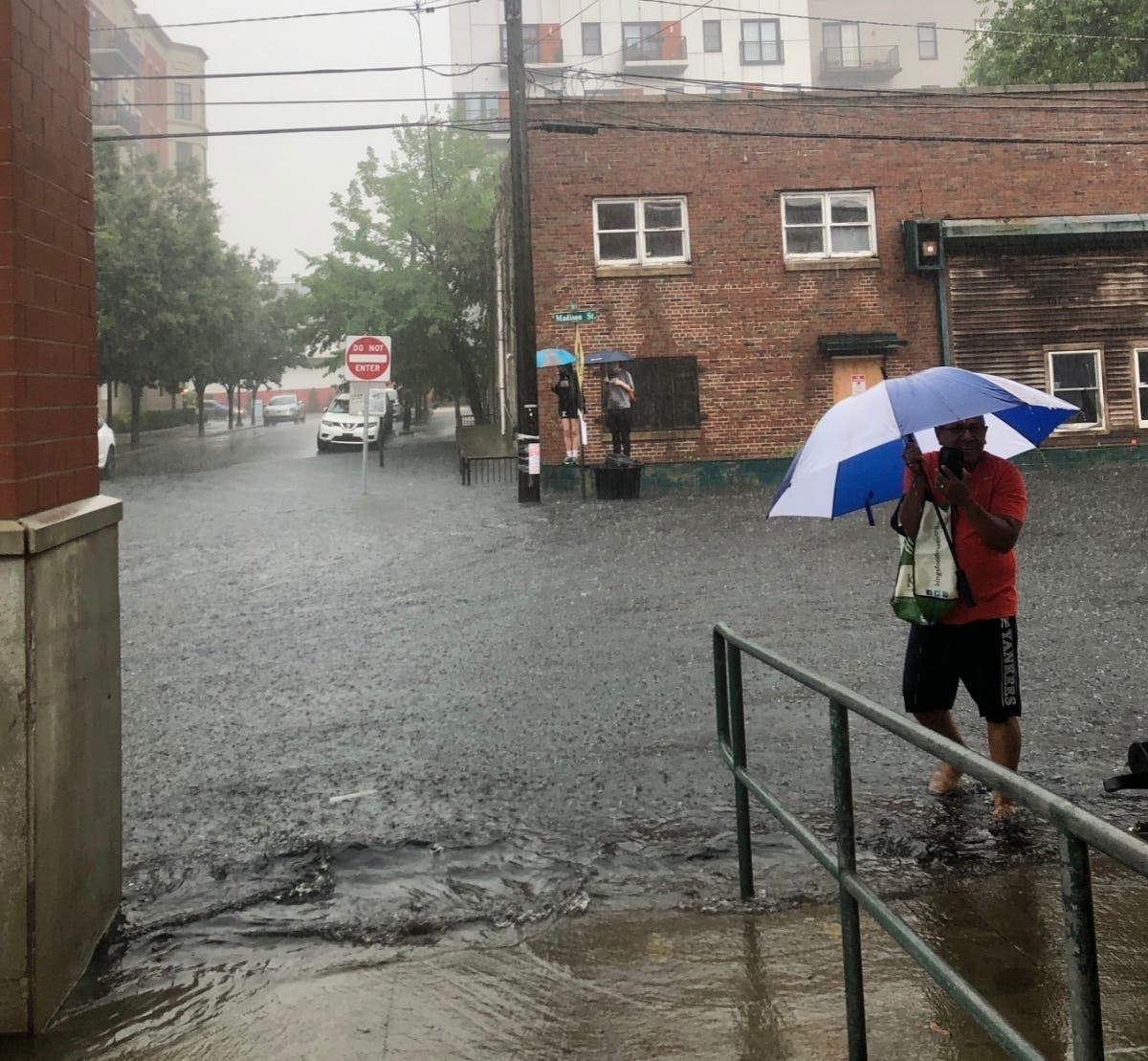

HOBOKEN, NJ — Hoboken residents posted photos of flash flooding on social media Saturday night even before the brunt of Hurricane Henri bore down on the area.
[See SUNDAY UPDATE: Hoboken Floods A Second Day Amid Henri]
"Last night, rain from Hurricane Henri hit Hoboken with a record high rainfall of 4.07 inches over a nearly 4.5-hour period," wrote the city in a new update Sunday morning, "the most rain recorded in a single storm since 2016."
Find out what's happening in Hobokenfor free with the latest updates from Patch.
The flood watch for Hudson County now runs through 8 p.m. on Monday, and Hudson County remains under a tropical storm warning through Sunday night.
As a downpour soaked Hoboken on Saturday night, several Twitter users posted photos of flash floods and another noted a shaky manhole cover. One photographer posted video of people crossing Newark Street during flooding.
Find out what's happening in Hobokenfor free with the latest updates from Patch.
Flooding already #hoboken #henri pic.twitter.com/EKbvT1RSB5
— Marlene (@Marlenestello) August 22, 2021
Hoboken is known to experience flooding during severe downpours; in fact, the city experienced flash floods twice last month as well as twice in July 2020. Last month, a flash flood trapped shoppers in a supermarket parking lot. READ MORE: Flash Flooding Traps Shoppers In Hoboken Lot
Hoboken had issued storm guidance on Saturday, saying, "During the storm, residents are advised not to travel or drive. Residents are encouraged to stay home." The city also noted that in severe storms, "Areas west of Bloomfield Street may experience street level flooding." The city offered parking for residents.
Want breaking news when it happens in Hoboken? Sign up for occasional breaking news alerts, and/or get a free daily newsletter at 6 a.m. each morning with local news. Sign up with your preferences here.
The city also advised, "Residents should prepare for Tropical Storm Henri by reviewing the Hoboken Ready website and flyer available in English and Spanish. Residents are encouraged to read through the Hurricane Survival Guide for New Jersey and take the actions necessary to secure your family and home."
(Flash floods could prove dangerous; see lists below of streets that sometimes flood in Hoboken.)
The tropical storm warning statement as of Sunday predicted "Peak Rainfall Amounts: Additional 2-4 inches, with locally higher amounts." The forecast is here.
High tide in Hoboken is expected at 9:31 p.m. Sunday.
Track Henri with these maps from the National Hurricane Center:
Read Patch coverage:
- Tropical Storm Henri Shifts West, May Impact New Jersey
- Tropical Storm Henri Could Hit NYC This Weekend
- Long Island Needs To Prepare For Henri: FEMA
Streets That May Flood In Hoboken
Damaging winds could blow down trees and power lines, resulting in power outages. Please report power outages and downed wires to PSEG at https://nj.myaccount.pseg.com/....
Residents should secure all loose objects outside or bring them inside, especially on balconies. Outdoor tents should be taken down depending on wind load.
Flooding is expected in flood prone intersections. Areas west of Bloomfield Street may experience street level flooding. The Office of Emergency Management is posting “No Parking Signs” in these areas, which should be taken as advisories. Cars will not be towed. Barricades will be deployed near flood-prone intersections. Please do not drive around barricades.
These intersections include:
- 1st and Marshall
- 1st and Harrison
- 2nd and Harrison
- 3rd and Harrison
- 4th and Harrison
- 4th and Monroe
- 3rd and Jackson
- 4th and Jackson
- 9th and Monroe
- 9th and Madison
- 10th and Madison
- 1st and Clinton
- 3rd and Clinton
- Henderson and Newark
- Grove and Newark
Please report flooded intersections and clogged drain inlets by calling the NHSA Hotline at (866) 689-3970.
Discounted parking
Residents are encouraged to move their cars from flood prone areas. Due to the predicted storm, a special rate of $5 per 24-hour period is being offered in Garages B (28 2nd Street) and D (215 Hudson Street) to residents with a valid Resident On-Street Parking Permit or Temporary Parking Permit, beginning at 2 p.m. on Saturday, August 21 through 8 am Monday, Aug. 23. In addition, Hoboken residents with disabilities who possess either a handicapped license plate or hang tag for their permitted vehicle may also park in the Midtown garage (371 4th Street) for the same reduced rate. Garage space is available on a first-come, first-served basis. Regular rates apply at other times.
See more of the city's guidance here.
Flash Floods Have Proved Fatal
While some may consider flash floods just an inconvenience, these floods have proved fatal to drivers (sometimes trapping parents and children in their cars as water rises) and to children playing near small streams.
Locally, a flash flood near the Hoboken ShopRite before Tropical Storm Elsa last month temporarily stranded shoppers. READ MORE: Flash Flooding Traps Shoppers In Hoboken Lot
Severe storms are becoming more frequent. In fact, the current Hurricane Elsa in July 2021 was the earliest E-named storm in modern weather history.
Cable Company Guidance
This week, the local cable company for the Hudson County area, Optimum, released guidance about upcoming storms:
"With Tropical Storms Fred, Grace and Henri making their way up the coast, we want to remind you of the resources available to you and assure you we are prepared for storm-related outages.
"While some outages cannot be prevented as they’re caused by downed wires and power lines, our fully staffed teams are standing by to assist our customers if there are any storm-related outages as soon as it is safe to do so. If unpreventable service outages do occur, restoring your Optimum service is always our top priority. We have made sure that our generators are checked and ready in case of any extended power outages."
How you can prepare:
• Have all your devices charged and ready.
• If you haven't yet signed up for text message alerts, do it now so you get the latest information right to your phone. Sign up for text message alerts.
• Have your Optimum ID ready so you can quickly log in to your account, check for service status updates, and find online support.
• Don't have an Optimum ID? Create One
• Can't remember your Optimum ID or password? Get a reminder
• Make sure your profile is up to date:
• Verify contact information and enroll in "Service Alerts" on the
My Profile page
• Add important email accounts to mobile devices and tablets using
these easy-to-follow instructions; Apple Devices, Samsung Devices.
• • Follow us on Social Media:
• Twitter – @OptimumHelp
• Facebook – Optimum
Want breaking news when it happens in Hoboken? Sign up for occasional breaking news alerts, and/or get a free daily newsletter at 6 a.m. each morning with local news. Sign up with your preferences here.
Got news? Email caren.lissner@patch.com. Got photos? Please include express written permission from the photographer for us to use them. To be the first to get free news alerts with breaking stories in your town, or to get a free local newsletter each morning, sign up for Patch breaking news alerts or daily newsletters.
Get more local news delivered straight to your inbox. Sign up for free Patch newsletters and alerts.