Weather
Hoboken Under Flash Flood Watch As Tropical Depression Ida Nears
Heavy rain is expected for Wednesday night. The Hoboken area is under a flash flood watch from Wednesday afternoon to Thursday afternoon.

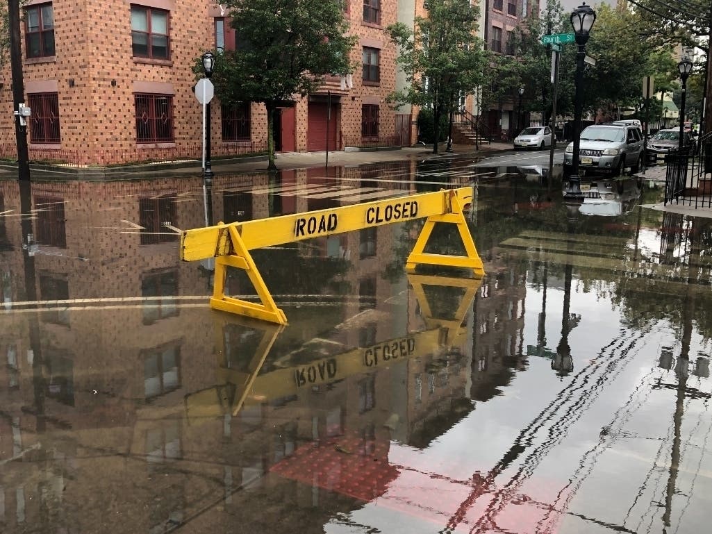


HOBOKEN, NJ — The remnants of Hurricane Ida —the storm that plunged New Orleans into darkness this weekend — may cause heavy rain in Hoboken on Wednesday into Thursday, dumping as much as three inches Wednesday night, the National Weather Service says.
The area is under a flash flood watch from 2 p.m. Wednesday to 2 p.m. Thursday. See all watches and warnings for the area here.
Find out what's happening in Hobokenfor free with the latest updates from Patch.
High tide in Hoboken Wednesday will be at 5:08 p.m. Wednesday and 6:01 a.m. Thursday.
The forecast says:
Find out what's happening in Hobokenfor free with the latest updates from Patch.
Wednesday Night: Rain and possibly a thunderstorm. Some of the storms could produce heavy rainfall. Low around 65. Northeast wind 8 to 11 mph, with gusts as high as 25 mph. Chance of precipitation is 90 percent. New rainfall amounts between 2 and 3 inches possible.
Thursday: Rain likely before 2 p.m., then a chance of showers after 2pm. The rain could be heavy at times. Mostly cloudy, with a high near 76. Chance of precipitation is 60%. New precipitation amounts between three quarters and one inch possible.
A hazardous weather outlook for Hudson County, as well as Bergen, Essex, Passaic, and Union counties, said, "Flooding is a possibility, especially across urban and poor drainage areas. However, there still is some uncertainty as to where the heaviest rain will be."
- To track the storm on the National Hurricane Center site, click here.
- See the potential rainfall map here.
- See current watches and warnings for Hudson County here.
See the forecast for Hudson County here.
Intersections In Hoboken And Jersey City That May Flood
Jersey City has 14 "repeat flooding" intersections. See that list here.
The intersections in Hoboken that are most likely to flood include:
- 1st and Marshall
- 1st and Harrison
- 2nd and Harrison
- 3rd and Harrison
- 4th and Harrison
- 4th and Monroe
- 3rd and Jackson
- 4th and Jackson
- 9th and Monroe
- 9th and Madison
- 10th and Madison
- 1st and Clinton
- 3rd and Clinton
- Henderson and Newark
- Grove and Newark
Report flooded Hoboken intersections and clogged drain inlets by calling the NHSA Hotline at (866) 689-3970. Report power outages and downed wires to PSEG at https://nj.myaccount.pseg.com/....
Floods This Summer
Low-lying Hoboken is known to experience flooding during severe downpours; in fact, the city experienced flash floods twice last month as well as twice in July 2020. Last month, a flash flood trapped shoppers in a supermarket parking lot. READ MORE: Flash Flooding Traps Shoppers In Hoboken Lot
And Tropical Storm Henri flooded several Hoboken intersections a week ago.
While some may consider flash floods just an inconvenience, these floods have proved fatal to drivers (sometimes trapping parents and children in their cars as water rises) and to children playing near small streams.
Severe storms are becoming more frequent. In fact, Hurricane Elsa in July 2021 was the earliest E-named storm in modern weather history.
Want breaking news when it happens in Hoboken? Sign up for occasional breaking news alerts, and/or get a free daily newsletter at 6 a.m. each morning with local news. Sign up with your preferences here.
Got news? Email caren.lissner@patch.com. Got photos? Please include express written permission from the photographer for us to use them. To be the first to get free news alerts with breaking stories in your town, or to get a free local newsletter each morning, sign up for Patch breaking news alerts or daily newsletters.
Get more local news delivered straight to your inbox. Sign up for free Patch newsletters and alerts.


