Weather
New Snowfall Map Issued For Hoboken Area For President's Day
New snowfall maps were issued for Hoboken for Presidents' Day morning. See the expected accumulation.

HOBOKEN, NJ — Tired of the snow? You may have to deal with it one more time this weekend.
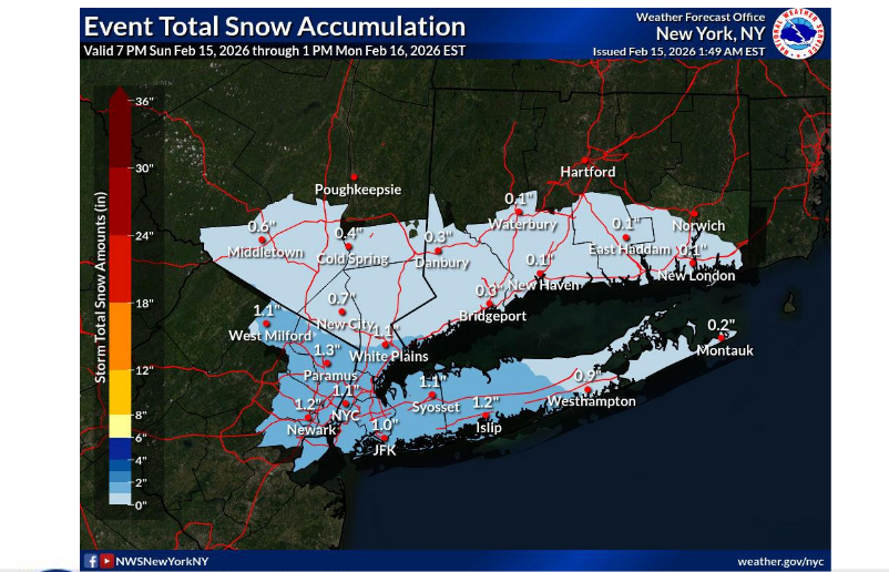
The National Weather Service says an inch or more of the white stuff could accumulate from Sunday night through Presidents' Day morning, making for slippery roads.
"The current weather forecast predicts light overnight snow beginning tonight, Sunday, Feb. 15 into Monday, Feb. 16, with a possible accumulation of up to 2 inches. The Department of Public Works (DPW) will pre-treat roads this evening, and additional crews will be on standby in the event that plowing is required."
Find out what's happening in Hobokenfor free with the latest updates from Patch.
As for the rest of the week, there's a chance of rain on Wednesday and Friday nights.
Stay up to date: To get the latest forecasts, radar, and more, come back to Patch and use the links below.
Find out what's happening in Hobokenfor free with the latest updates from Patch.
Track Storms Here
- See the latest local NWS forecast and watches here.
- Keep an eye on the local radar here.
- Check out the Accuweather Minutecast here.
- See a current map of all watches and warnings in New Jersey here.
- The NOAA (National Oceanic and Atmospheric Administration) keeps us informed about larger weather events. Follow them here.
Updated NWS forecasts, watches, and warnings in each county:
Get more local news delivered straight to your inbox. Sign up for free Patch newsletters and alerts.