Weather
'Strong To Severe' Thunderstorms Could Hit North Jersey Tuesday Afternoon, Evening
Forecasters predict stormy weather for Tuesday afternoon and evening, with possible gusty winds and hail, but less rain than Hurricane Ida.


NORTH JERSEY — "Strong to severe" thunderstorms could hit North Jersey Tuesday afternoon and evening with damaging wind gusts and hail, the National Weather Service said.
"Stronger, potentially severe storms are likely beginning around the early afternoon as a cold front moves in from the north," said the National Weather Service office based in Mt. Holly. "The period of concern begins around the 1 to 3 p.m. time frame for northern areas from the Lehigh Valley into the southern Poconos and Northwest New Jersey, with storms likely affecting the I-95 urban corridor towards the 4 to 6 p.m. period."
Storms were expected to roll into the Northeastern counties some time after 2 p.m., said the National Weather Service New York Office. Storms could produce gusty winds and continue any time through 8 p.m., with a "slight chance of showers and thunderstorms between 8 p.m. and 11 p.m."
Find out what's happening in Hobokenfor free with the latest updates from Patch.
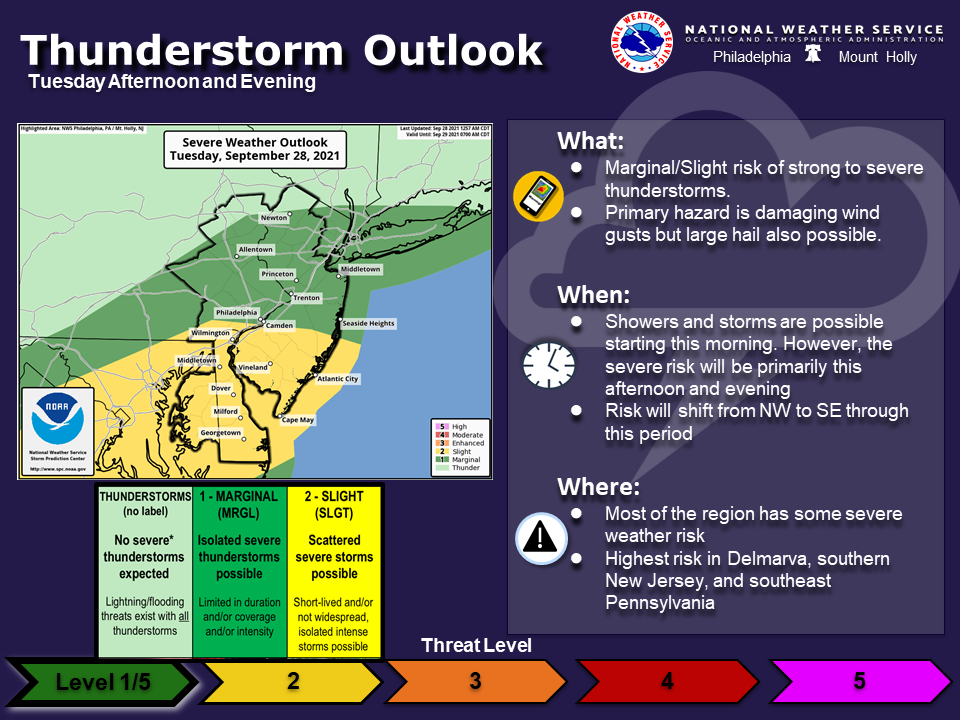
The Mt. Holly office said that statewide, "Primary hazard is damaging wind gusts but large hail also possible...severe risk will be primarily this afternoon and evening."
'Strong To Severe' In Northeastern NJ
Find out what's happening in Hobokenfor free with the latest updates from Patch.
The NWS released a hazardous weather outlook for Union, Essex, Hudson, Passaic, and Bergen counties, as well as southern counties. "Isolated strong to severe thunderstorms are possible during the afternoon and evening hours," said the New York office.
No Flood Advisory, Less Rain
But unlike with recent storms, the NWS did not expect flooding or excessive rain.
While Tropical Depression Ida brought 5 to 9 inches of rain, according to spotters, forecasters expect that on Tuesday afternoon, "New rainfall amounts between a tenth and quarter of an inch, except higher amounts possible in thunderstorms."
By Wednesday, pleasant fall weather is expected to return, with sunny skies and a high near 68.
Here is the prediction for Tuesday afternoon and evening:
Tuesday: A chance of showers and thunderstorms, then showers likely and possibly a thunderstorm after 2 p.m. Some of the storms could produce gusty winds. Mostly cloudy, with a high near 77. West wind 6 to 9 mph. Chance of precipitation is 70 percent. New rainfall amounts between a tenth and quarter of an inch, except higher amounts possible in thunderstorms.
Tuesday Night: Showers likely and possibly a thunderstorm before 8 p.m., then a slight chance of showers and thunderstorms between 8 p.m. and 11 p.m. Mostly cloudy, with a low around 55. North wind 8 to 11 m.p.h. Chance of precipitation is 60 percent.
Wednesday: Sunny, with a high near 68. North wind 8 to 10 m.p.h.
Watch Patch for severe weather updates.
Want updates on breaking news when it happens? You can sign up for occasional breaking news alerts in your New Jersey town, or for a daily newsletter at 6 a.m. each morning with local news. Don't miss the stories your neighbors are talking about! Sign up with your preferences here.
Got photos? Please include express written permission from the photographer for us to use them. To be the first to get free news alerts with breaking stories in your town, or to get a free local newsletter each morning, sign up for Patch breaking news alerts or daily newsletters.
Get more local news delivered straight to your inbox. Sign up for free Patch newsletters and alerts.


