Weather
Timeline For Strong Storms, 30-MPH Winds Expected In NJ
New Jersey will get storms from heavy moisture produced by Tropical Storm Michael. Here's where and when they'll come.


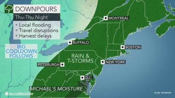
New Jersey will get a day of strong storms and winds as moisture from Tropical Storm Michael heads northeast.
The actual storm isn't expected to hit the New Jersey mainland, but we're expected to get hit hard by moisture produced by the weather system that slammed into the Florida panhandle on Wednesday, carrying 155-mph winds.
A flash flood watch will be in effect for almost the entire state beginning at 2 p.m. and lasting until 5 a.m. on Friday, though rain is expected to start falling after 11 a.m. Two to four inches of rain are expected to fall, according to the National Weather Service. Parts of New Jersey could experience 20- to 30-mph winds.
Find out what's happening in Lakewoodfor free with the latest updates from Patch.
Don't go swimming or boating in the ocean: A gale warning is in effect as a strong cold front will cross the region and interact with the remnants of Tropical Storm Michael, according to the NWS.
Here are the alerted areas:
Find out what's happening in Lakewoodfor free with the latest updates from Patch.
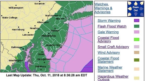
The National Weather Service says the worst-hit areas will be the Jersey Shore, Central and South Jersey and along the Interstate 95 corridor, extending into the Bergen and Hudson County areas.
Here's what's expected to happen:
- Showers will develop through Thursday, with the heaviest rainfall expected this afternoon through late tonight. Rainfall totals of 2 to 4 inches, with locally higher amounts, will fall during this time, according to the National Weather Service.
- In the Jersey Shore and South Jersey, from Monmouth County all the way down to Cape May, scattered showers along with a rumble of thunder are expected on Thursday. Gusty winds of up to 30 mph are also possible, especially along the shore, both on Thursday and early Friday. Rains will become steady and heavier later today.
- The Interstate 95 and New Jersey Turnpike corridor is susceptible to heavy rain and flash flooding, and flash flooding is possible on roadways and especially in areas of poor drainage, according to the National Weather Service. Minor flooding along small streams and creeks is possible as well.
- Heavy rain is expected to occur over a short period of time. Rapidly rising flood waters may quickly inundate roadways and areas of poor drainage. Streams and creeks could leave their banks, flooding nearby properties, according to the NWS.
Here is the forecast:
- Thursday: Showers and possibly a thunderstorm. Some of the storms could produce heavy rain. High near 80. South wind 8 to 13 mph. Chance of precipitation is 100%. New rainfall amounts between three quarters and one inch possible.
- Thursday night: Showers and possibly a thunderstorm before 2am, then a chance of showers. Some of the storms could produce heavy rain. Low around 58. Light and variable wind becoming north 9 to 14 mph after midnight. Chance of precipitation is 90%. New precipitation amounts between 1 and 2 inches possible.
- Friday: Mostly sunny, with a high near 64. Northwest wind 9 to 17 mph, with gusts as high as 30 mph.
- Friday night: Partly cloudy, with a low around 46. Northwest wind 5 to 8 mph.
Tom Davis photo
Get more local news delivered straight to your inbox. Sign up for free Patch newsletters and alerts.