Crime & Safety
Could a Hurricane Hit N.J. Labor Day Weekend?
While some forecasters say it's unlikely, another forecast model raised alarm bells.

Labor Day weekend is more than a week away, and a lot can happen with the weather between now and then.
One thing that hasn’t been ruled out: a hurricane, or tropical storm, hitting New Jersey.
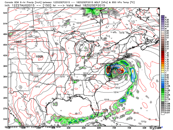
One Canadian forecast model shows Tropical Storm Erika heading toward the East Coast before making a left turn, veering toward New Jersey.
Find out what's happening in Livingstonfor free with the latest updates from Patch.
The forecast model was alarming enough to capture the attention of Gary Szatkowski, meteorologist at the National Weather Service’s Mount Holly office, who retweeted the picture on his personal email account on Thursday.
Szatkowski also took to Twitter to warn people that, while the storm may not directly hit New Jersey, everyone should be prepared for any possible impacts.
Find out what's happening in Livingstonfor free with the latest updates from Patch.
“Recommendation today is the same as yesterday. Have a hurricane plan that is ready to go if needed and keep an eye on the forecast,” he said.
He said there is some potential Erika will “recurve” into the Atlantic Ocean. It also could be headed toward the Gulf of Mexico.
“Bottom line is many options remain on the table,” he said on Twitter.
Some forecasters say the storm could strengthen into a hurricane as it moves across the water, and heads toward Florida - or the Mid-Atlantic states.
If it were to veer toward New Jersey, it could be the first hurricane or tropical storm to possibly hit New Jersey since Superstorm Sandy devastated the state in October 2012.
In an interview with nj.com, Szatkowski tried to reassure people that it’s way too early to predict what could happen.
“I don’t think people should be expending too much of their brain power on Erika right now.”
Others say that New Jersey could share in these impacts if the storm approaches the Mid-Atlantic, but it remains unlikely that the storm will directly hit the state’s shores.
AccuWeather.com predicts that the effects of the storm will be greatest along the Atlantic coast of Florida, including the back bays. East to northeast winds may cause some water to pile up.
There are multiple scenarios on the exact track and intensity of Erika once it clears the northern islands of the Caribbean, according to AccuWeather. It could slip just to the west of Florida, or head right over Florida, or curve to the east, according to AccuWeather.
How soon Erika makes more of a turn to the northwest and then to the north will determine the extent of impacts in the Bahamas and Florida, according to AccuWeather. If the system survives as far north as Florida, there will be concerns farther north into the Southern states, according to AccuWeather.
Photo: Canadian forecast model retweeted by Gary Szatkowski.
Get more local news delivered straight to your inbox. Sign up for free Patch newsletters and alerts.