Weather
Winter Weather Advisory In 10 NJ Counties For New Snow
Here's what to expect, and how much you could get.


UPDATED: Winter Storm Warning In 18 NJ Counties: Here's What To Expect
ORIGINAL STORY: More winter weather is expected to batter New Jersey this weekend now that a winter weather advisory was issued for 10 New Jersey counties. And a larger system could be coming on Sunday and Monday.
The winter weather advisory was issued for snow that's expected to largely impact 10 counties on Friday night and Saturday morning.
Find out what's happening in Manasquan-Belmarfor free with the latest updates from Patch.
The National Weather Service also has issued a hazardous weather outlook for the entire state, saying a winter storm Sunday night into early Monday has the potential to produce "significant snowfall and hazardous travel." Some areas could also transition to a wintry mix for a time.
More than 4 inches fell in some spots in New Jersey, and even more could fall this weekend. Read more: New Jersey Snow Totals, Town-By-Town, For Friday Through Monday
Find out what's happening in Manasquan-Belmarfor free with the latest updates from Patch.
More than 200 schools or school districts were impacted by Friday's snow, and more could be affected on Monday. Read more: New Jersey School Closings/Delays List For Monday
The winter weather advisory was issued for Passaic, Bergen, Essex, Hudson, Union, Sussex, Morris, Hunterdon, Warren and Somerset counties, but it could expand.
Here are the alerted areas:
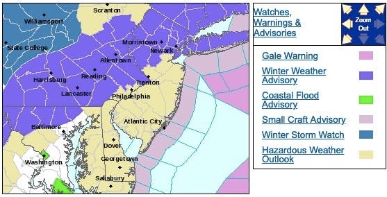
Here's is what to expect in the areas that are under the advisory:
- Mixed precipitation expected. Total snow accumulations of 2 to 4 inches and ice accumulations of a light glaze expected.
- WHEN...From 9 p.m. this evening to 7 a.m. Saturday.
- ADDITIONAL DETAILS...Plan on slippery road conditions with reduced visibilities at times Friday night into Saturday morning.
Following patches of snow and a wintry mix into Saturday night, a larger storm is poised to bring snow, ice and rain later in the weekend to Monday, according to AccuWeather.
The storm that follows later Sunday to Monday will bring rain to some areas that get snow from Friday to Saturday and but also snow to some areas that end up being largely missed by snow to end this week, according to AccuWeather.
A more eastward path by the storm might result in several inches of wet snow or a heavy wintry mix from the mountains of West Virginia to northern Virginia, northern Maryland, southeastern Pennsylvania, Delaware, much of New Jersey, southeastern New York state and southern New England, according to AccuWeather.
Gusty winds will accompany the leading edge of the Arctic air, and blustery conditions will linger for a couple of days. However, winds are not forecast to be as intense as the hurricane-force gusts that occurred in some areas at the start of this week, according to AccuWeather. Gusts between 30 and 45 mph are likely in the Northeast.
-1551446559-9285.jpg)
Here is the forecast:
- Friday night: A chance of rain before 10pm, then rain, snow, and sleet. Low around 32. Northeast wind 7 to 9 mph. Chance of precipitation is 90%. Total nighttime snow and sleet accumulation of around an inch possible.
- Saturday: A chance of rain, snow, and sleet before 8am, then a chance of rain between 8am and noon. Cloudy, with a high near 41. Northeast wind 7 to 10 mph becoming west in the afternoon. Chance of precipitation is 40%. New snow and sleet accumulation of less than a half inch possible.
- Saturday Night: Mostly cloudy, with a low around 29. Northwest wind 5 to 7 mph.
- Sunday: Rain likely, mainly after 4pm. Mostly cloudy, with a high near 41. Northwest wind around 5 mph becoming calm in the morning. Chance of precipitation is 70%. New precipitation amounts of less than a tenth of an inch possible.
- Sunday Night: Rain and snow, becoming all snow after 10pm. Low around 32. East wind 5 to 8 mph becoming north after midnight. Chance of precipitation is 100%. New snow accumulation of 1 to 2 inches possible.
- Monday: A slight chance of snow showers before 10am. Partly sunny, with a high near 39. Chance of precipitation is 20%.
Get more local news delivered straight to your inbox. Sign up for free Patch newsletters and alerts.