Weather
NJ Weather Warnings: Damaging Winter Storm Could Batter State
A bad, damaging winter storm is hitting New Jersey, but it won't be all about the snow.

A bad, damaging winter storm is hitting New Jersey, but it won't be all about the snow.
Arctic blasts and plenty of snow are expected to fall anytime from Thursday through Sunday, with some strong, tropical storm-force winds are hitting New Jersey - or as one forecaster put it, "A lot of winter coming at you fast."
Find out what's happening in Mendham-Chesterfor free with the latest updates from Patch.
The National Weather Service issued a hazardous weather outlook for the entire state. Here is what is expected to happen and what's possible:
- Bitter cold is moving into the area, with wind chills temperatures in the single-digits Thursday night.
- Wind gusts could approach 40 to 60 mph on Thursday.
- Snow will likely overspread the area Friday night and then transition into a wintry mix on Saturday.
- The region will be hit by "snow squalls," which are small, short blizzard-like blasts of snow and wind.
- Light icing is possible during the transition to a wintry mix.
- About an inch of snow and ice is expected to be on South Jersey and Jersey Shore roads.
- One to 3 inches are expected for Central Jersey.
- Two to 4 inches are expected for North Jersey (north of Union County).
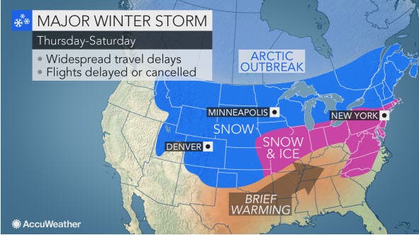
Here is a map of what New Jersey residents should be seeing:
Find out what's happening in Mendham-Chesterfor free with the latest updates from Patch.
And here are some updated snowfall numbers from @NWS for the weekend event. pic.twitter.com/15xMz0KhWx
— Gary Szatkowski (@GarySzatkowski) December 15, 2016
The storm is part of a larger system that will create dangerous travel conditions across a 1,200-mile swath of the United States into the weekend.
Blizzard conditions could develop in major hubs such as Denver and Chicago. People from the Rockies to the northern Plains and Upper Midwest are bracing for a new round of snow and travel disruptions on the highways and at airports. But the same issues could impact our area.
"Motorists and airline passengers may want to explore an alternate or more southern route as confidence is high that there will be widespread, major travel disruptions with this storm," AccuWeather Senior Meteorologist Brett Anderson said.
The storm will bring a wintry and icy mix with slippery travel from as far south as the Carolinas to as far north as Maine during the weekend. The storm will bring the first accumulating snow to Washington, D.C., and enough snow to shovel and plow from Philadelphia to New York City and Boston.
Here is the NWS weather forecast for the area:
- Thursday: A slight chance of snow showers between 11am and 2pm. Partly sunny, with a high near 23. Blustery, with a northwest wind 16 to 21 mph, with gusts as high as 31 mph. Chance of precipitation is 20 percent.
- Thursday night: Partly cloudy, with a low around 9. Wind chill values as low as -3. West wind 11 to 17 mph.
- Friday: Mostly sunny, with a high near 23. Wind chill values as low as zero. Northwest wind around 6 mph becoming light and variable in the afternoon.
- Friday night: Snow, mainly after 1am. Low around 17. South wind 3 to 7 mph. Chance of precipitation is 90%. New snow accumulation possible.
- Saturday: Snow and sleet before 1pm, then a chance of freezing rain between 1 and 4 p.m., then a chance of rain after 4pm. High near 45. Southwest wind 7 to 10 mph. Chance of precipitation is 100 percent. Little or no ice accumulation expected. New snow and sleet accumulation possible.
- Saturday night: Rain likely, mainly after midnight. Cloudy, with a low around 35. Chance of precipitation is 70 percent. New precipitation amounts between a quarter and half of an inch possible.
- Sunday: Rain likely before 2 p.m., then a chance of sleet between 2 and 5 p.m., then a chance of snow and sleet after 5pm. Cloudy, with a high near 43. Chance of precipitation is 60 percent.
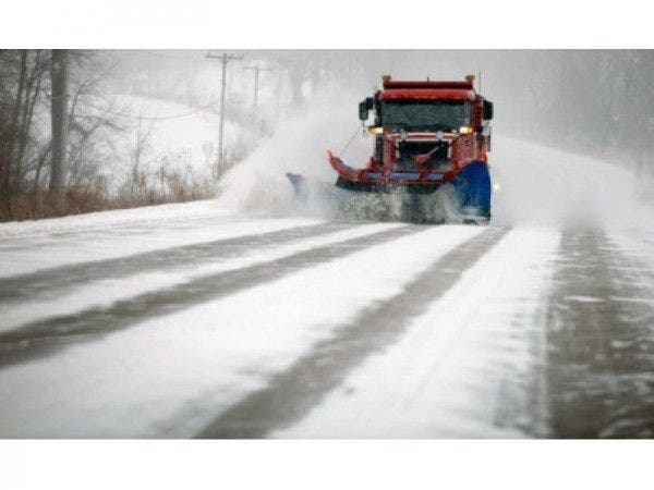
Patch file photo
Get more local news delivered straight to your inbox. Sign up for free Patch newsletters and alerts.