Weather
NJ Weather Advisory Issued: Storm Heading Our Way
A storm that could provide anything from an annoying mix of snow and freezing rain to a heavy heaping of snow is expected to hit N.J.


A storm that could provide anything from an annoying mix of snow and freezing rain to a heavy heaping of snow is expected to hit New Jersey beginning on Friday night.
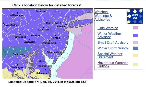
The National Weather Service has issued a "winter weather advisory" that will remain in effect from 10 p.m. Friday evening until 2 p.m. Saturday.
Read more: Hour-By-Hour Forecast Of Winter Weather For N.J. Commute, Weekend
Find out what's happening in Toms Riverfor free with the latest updates from Patch.
Here is what the NWS is saying about the storm:
- Hazard types...snow...sleet and freezing rain.
- Ice accumulations...around a tenth of an inch. Potential for locally higher amounts around two tenths of an inch at higher.
- Snow accumulations...Up to 2 to 4 inches in Morris, Sussex, Warren and Hunterdon counties, about 1 to 3 inches of snow and ice everywhere else.
- Timing...snow is forecast to overspread the region from the west late this evening and overnight. The snow could be moderate heavy for fa ew hours late tonight. The snow is expected to change to sleet and freezing rain by around daybreak Saturday in southeastern Pennsylvania and during the mid morning farther north across the I-78 corridor. The freezing rain will taper off to light rain and drizzle during the early afternoon.
- Impacts...the snow and ice will create hazardous travel conditions.
- Temperatures...rising from the 20s into the 30s during the advisory period.
- Visibilities...less than a half mile at times late tonight.
- Precautionary/preparedness actions... a winter weather advisory means that periods of snow...sleet... and freezing rain will cause travel difficulties. Be prepared for slippery roads and limited visibility...and use extra caution while driving.
Here are the warning areas:
Find out what's happening in Toms Riverfor free with the latest updates from Patch.
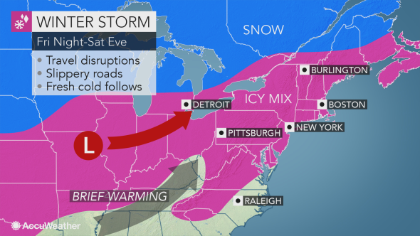
From New York City to Boston and much of southern New England, this will likely be the biggest snowfall of the season so far, according to an AccuWeather release.
Areas from Pennsylvania to New Jersey and New York can expect mostly snow to spread over the area from west to east during late Friday night. The snow will reach much of New England by Saturday morning.
During much of Saturday, motorists will face slow and slippery travel from the northern mid-Atlantic states through New England. Road conditions will range from snow-covered to slushy or wet.
"The snow can come down hard at first, which could quickly cover roads, highways and sidewalks in the major cities from the I-99 and I-81 corridors to the I-95 cities of Philadelphia, New York City and Boston with this storm," AccuWeather Senior Meteorologist Henry Margusity said in the release.
"Enough snow to shovel and plow can fall in these areas prior to any change to ice and rain later Saturday and Saturday night," Margusity said.
The snow will be dry and powdery at first but will become heavy, wet and eventually slushy as the storm progresses. Substantial airline delays are likely with the potential for a significant number of flight cancellations.
Maintenance personnel will have to deice aircraft and clean snow from runways. Airline crews and aircraft may be displaced because of the vast expanse of the storm from the Rockies to the Midwest and Northeast, according to AccuWeather.
Warmer air will flow in quickly later Saturday and Saturday night in coastal and southern areas, as well as locations west of the Appalachians. However, a wedge of chilly air may remain in the central and northern Appalachians, causing an extended period of ice. These areas will be at greatest risk for trees and power lines coming down.
Travel conditions will improve from south to north Saturday afternoon into Sunday morning. However, some problems will remain. Locally gusty winds are possible in coastal areas. Areas of fog are possible as well, according to the release.
By Sunday morning, most areas in the Northeast will have warmed up enough for rain to fall. However, another wave of arctic air will begin to push across the Appalachians during the afternoon.
Cold air could catch up with the rain fast enough to bring a change to sleet and snow in the Appalachians during Sunday, according to AccuWeather.
Read more: Winter Weather Advisory Issued For All N.J.; Storm Heading Our Way
Patch file photo
Get more local news delivered straight to your inbox. Sign up for free Patch newsletters and alerts.