Weather
In Ida's Wake: Drone Captures Videos Of 2 Rivers In Essex County
See bird's eye footage of the Passaic River and the Third River, taken just days after Hurricane Ida caused flooding across Essex County.


ESSEX COUNTY, NJ — There are good things and bad things about living near a river. And one of the latter is flooding.
When Hurricane Ida hit last week, rivers around New Jersey swelled, adding another layer of anxiety for the residents and business owners already struggling with devastating flood damage. Read More: Essex County Not On FEMA Disaster List For Ida Federal Aid
With weather forecasters calling for a high probability of rain and a "slight" risk of flash flooding on Wednesday, some local residents may be wondering about conditions at two major rivers that run through Essex County: the Passaic River and the Third River.
Find out what's happening in Montclairfor free with the latest updates from Patch.
See recent drone video footage taken of both rivers below. Sign up for Patch local weather and storm alerts here.
The Passaic River winds across nearly 80 miles of North Jersey, flowing through several counties until it joins the Hackensack River at the northern end of Newark Bay. Along the way, it passes by Essex County municipalities including Belleville, Nutley and Newark, with several other towns located within its watershed.
Find out what's happening in Montclairfor free with the latest updates from Patch.
Another local waterway, the Third River – also known as the Yantacaw River – passes through several Essex County towns including Montclair, Bloomfield and Nutley, eventually entering the Passaic River near the border of Nutley and Clifton.
So is the water level currently a threat at either river as of Wednesday?
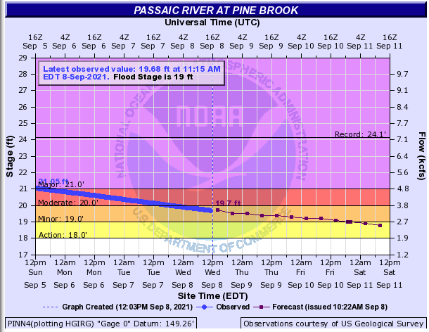
According to the National Weather Service, the level at the Passaic River in Little Falls was at 5.79 feet, below the 7-foot threshold that would result in “minor flooding.” In Newark, the Passaic River was observed at 6.32 feet on Wednesday. But the water level was more concerning in Morris County at Pine Brook, where the waterway rises and the flood stage is set higher, registering at 19.68 feet – which is almost at a “moderate” flood condition.
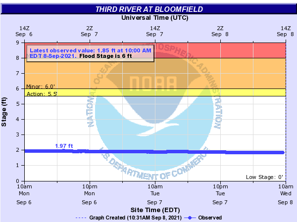
Meanwhile, the water level at the Third River as observed in Bloomfield was just under two feet, which is well-below the 6-foot threshold that would result in minor flooding.
GETTING A BIRD’S EYE VIEW
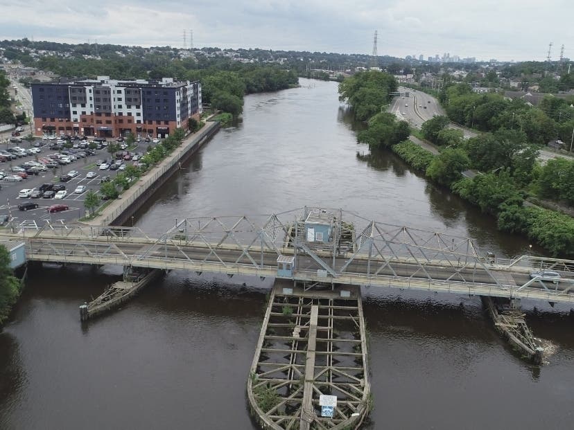
The following drone footage captured by Francis Gibbons shows the Passaic River near River Road in Nutley and Riverside County Park in Lyndhurst on Saturday, Sept. 4 (also see photos in gallery above).
The below footage shows the Third River as seen on Sept. 4 in Nutley and Montclair.
Send local news tips and correction requests to eric.kiefer@patch.com
Sign up for Patch email newsletters. Learn more about posting announcements or events to your local Patch site.
Get more local news delivered straight to your inbox. Sign up for free Patch newsletters and alerts.