Weather
109-Degree Heat? Timeline For Severe NJ Weather
Get ready for a 109-degree heat index and possibly severe New Jersey weather as temperatures zoomed past 100 degrees on Monday.


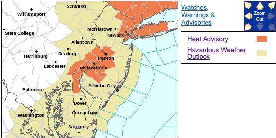
NEW JERSEY – Get ready for horrible heat and possibly severe New Jersey storms as the worst kind of summer weather may hit the region this week. The heat index hit 109 in one part of the state on Monday (see map below).
The National Weather Service has issued a hazardous weather outlook, saying heavy rain leading to localized flooding is possible, with thunderstorms arriving during the afternoon and evening of Tuesday, Wednesday and Thursday. Some storms are possible on Monday, too.
A heat advisory also was issued for several New Jersey counties since the heat index was supposed to hit between 100 to 104, but it already zoomed past that.
Find out what's happening in Ocean Cityfor free with the latest updates from Patch.
The highest heat index values will occur Monday afternoon and again Tuesday afternoon. The heat and humidity may last into Wednesday, according to the NWS.
Here are the alerted areas:
Find out what's happening in Ocean Cityfor free with the latest updates from Patch.
Here is what to expect:
- The heat index should zoom past 100 degrees and hit its peak around 2 p.m. on Monday.
- Some rain and thunder may arrive after 2 p.m. on Monday and 2 p.m. on Tuesday, but the worst may not arrive until after 2 p.m. on Wednesday.
- The stormy pattern will bring high humidity and thunderstorms to much of the region.
Here are the heat indexes in New Jersey at 3 p.m.:
.png)
Here are the heat indexes in New Jersey at 2:30 p.m.:
.png)
Here are the heat indexes in New Jersey at 1 p.m.:
.png)
Here are the heat indexes in New Jersey at 12 noon:
.png)
Here are the heat indexes in New Jersey at 11 a.m.:
.png)
Here are the heat indexes in New Jersey at 10 a.m.:
.png)
A few thunderstorms over the two-day period, meanwhile, could produce heavier downpours. The overall pattern will bring waves of showers and thunderstorms moving through the Northeast, said AccuWeather Meteorologist Tyler Roys.
"Localized cases of flash flooding and gusty winds will be the most likely severe threats, other than frequent lightning," added Roys in a release.
As a whole across the region, Wednesday's activity appears to be more widespread, according to AccuWeather.
"The most potent storms of the week look to move in with a cold front on Wednesday. Storms will be capable of producing hail, damaging winds and flash flooding," Roys said.
.png)
Here is the forecast:
- Monday: A chance of showers and thunderstorms, mainly after 1pm. Some of the storms could produce gusty winds. Partly sunny, with a high near 92. Heat index values as high as 101. Southwest wind 5 to 8 mph. Chance of precipitation is 30%. New rainfall amounts between a tenth and quarter of an inch, except higher amounts possible in thunderstorms.
- Monday night: A chance of showers and thunderstorms, mainly before 9pm. Some of the storms could produce gusty winds. Partly cloudy, with a low around 72. Light northwest wind. Chance of precipitation is 30%. New precipitation amounts between a tenth and quarter of an inch, except higher amounts possible in thunderstorms.
- Tuesday: A chance of showers and thunderstorms after 2pm. Some of the storms could produce heavy rain. Partly sunny, with a high near 90. Northeast wind 5 to 7 mph becoming southeast in the afternoon. Chance of precipitation is 50%. New rainfall amounts of less than a tenth of an inch, except higher amounts possible in thunderstorms.
- Tuesday night: A chance of showers and thunderstorms. Some of the storms could produce heavy rain. Mostly cloudy, with a low around 71. South wind around 5 mph. Chance of precipitation is 50%. New rainfall amounts of less than a tenth of an inch, except higher amounts possible in thunderstorms.
- Wednesday: Showers and thunderstorms likely, mainly after 2pm. Partly sunny, with a high near 91. South wind 6 to 9 mph. Chance of precipitation is 60%. New rainfall amounts between a tenth and quarter of an inch, except higher amounts possible in thunderstorms.
- Wednesday night: Showers and thunderstorms likely, mainly before 8pm. Mostly cloudy, with a low around 73. Chance of precipitation is 60%. New rainfall amounts of less than a tenth of an inch, except higher amounts possible in thunderstorms.
- Thursday: A chance of showers and thunderstorms, then showers likely and possibly a thunderstorm after 2pm. Partly sunny, with a high near 88. Chance of precipitation is 60%.
- Thursday night: Showers likely and possibly a thunderstorm before 8pm, then a chance of showers and thunderstorms between 8pm and 2am, then a chance of showers after 2am. Mostly cloudy, with a low around 63. Chance of precipitation is 60%.
Get more local news delivered straight to your inbox. Sign up for free Patch newsletters and alerts.