Weather
3 Tornadoes Confirmed In NJ As More Severe Weather Expected
More severe weather is expected just as the National Weather Service confirmed that three tornadoes touched town in New Jersey.

The National Weather Service confirmed that three tornadoes touched town in New Jersey this week as more severe weather is expected to hit the region. One tornado damaged solar panels and injured a woman.
The NWS has issued a statewide hazardous weather outlook, saying a storm system was expected to move through the region on Tuesday and Wednesday. Storms will be capable of producing severe weather and heavy rainfall that could lead to localized flooding, according to the NWS (see forecast below).
The storm possibility comes on the heels of severe weather that flooded roads, knocked out power to more than 19,000 people and brought high winds to New Jersey last Wednesday.
Find out what's happening in Point Pleasantfor free with the latest updates from Patch.
Here's where the tornadoes hit:
Hightstown in Mercer County
Find out what's happening in Point Pleasantfor free with the latest updates from Patch.
The tornado touched down at 4:33 p.m. on Wednesday, packing wind speeds of 75 mph. The weak tornado briefly touched down on the property of Voorhees Greenhouse in Hightstown. The tornado began near Sharon Road, where several trees and branches were downed, according to the NWS.
The most significant damage observed was to a greenhouse, whose glass roof was shattered. Shards of glass were blown for hundreds of yards, with many shards also piercing clean through the doors and walls of a nearby barn.
A few metal support beams from the greenhouse were also tossed up to 200 yards from their original position, with a number of loose outdoor objects tossed about in a chaotic, yet circular manner often consistent with tornado winds, according to the NWS.
Eyewitnesses working at the time reported seeing circulating winds and a possible condensation funnel as damage to the greenhouse was occurring.
The tornado then passed over a barn, scattering shards of glass, flower planters and support beams. Many of these objects were deposited on the other side of the barn into a nearby field.
Several trees sustained damage to limbs and branches, but all were left upright. The tornado dissipated as it moved into a clearing beyond the wooded area.
One woman received a minor cut from flying glass, but no serious injuries occurred as a result of this tornado (story continues below photo).

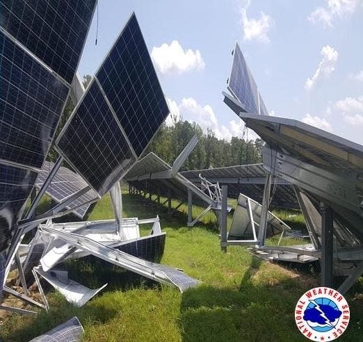
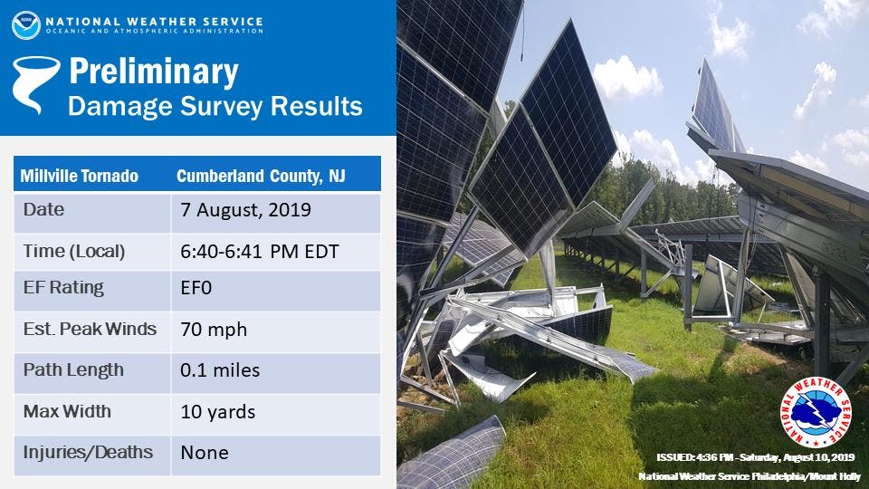
Millville in Cumberland County
The tornado touched down at 6:40 p.m., packing wind speeds of 70 mph. The weak tornado briefly touched down in a field of solar panels adjacent to the Millville City Sewer Department facility, according to the NWS.
Several rows of solar panels sustained damage either from the tornado or from the falling debris of other panels, with a couple rows of panels largely destroyed, according to the NWS. The tornado continued into a wooded area next to the solar panels, snapping at least one tree and damaging a couple others, but lifting soon after it entered the wooded area.
A twisting pattern observed in the damage to the solar panels was sufficient to determine that the damage was caused by a tornado. In addition, an eyewitness looking in the direction of the damage from near the nearby Millville Executive Airport reported a possible funnel cloud sighting as the storm passed the area.
No injuries occurred as a result of this tornado (story continues below photo).
Springfield in Union County
The National Weather Service also confirmed with Union County Emergency Management that a brief tornado touched down near Springfield Avenue and Route 22 in Springfield. Radar-estimated winds were 70 mph.
Here are videos of the twister and the damage it left:
TORNADO IN NJ: A tornado touched down in Springfield, New Jersey, the National Weather Service confirmed. Video shows what appears to be a funnel forming over a busy roadway, tossing debris into the air. https://t.co/3n0pdekccT pic.twitter.com/1dcAX0L8ow
— Eyewitness News (@ABC7NY) August 7, 2019
Confirmed tornado in Springfield, NJ. This is the parking lot off RT22 where it hit. @NWS says it was on the ground for no more than 4 minutes, about 70mph, around 2:47pm. Story tonight at 11pm on @ABC7NY pic.twitter.com/gUWRXQWjmG
— CeFaan Kim (@CeFaanKim) August 7, 2019
Exclusive NEW video of the #Springfield tornado ... hear from 11 year old boy who shot it on News 4 at 6pm #nbc4ny https://t.co/X5JNo7jgLX pic.twitter.com/6jclk48jYN
— Steven Bognar (@Bogs4NY) August 7, 2019
Some of the damage reported by the #Springfield tornado. Pics by @ChrisKeatingNJ Full story: https://t.co/R9SyG1qw2C pic.twitter.com/ix86XIq43R
— News12NJ (@News12NJ) August 7, 2019
Here is the forecast:
- Sunday: Sunny, with a high near 82. Calm wind becoming northwest 5 to 8 mph in the morning.
- Sunday night: Mostly clear, with a low around 59. Calm wind.
- Monday: Sunny, with a high near 86. Southwest wind 3 to 8 mph.
- Monday night: A slight chance of showers after 2am. Partly cloudy, with a low around 70. Southwest wind around 8 mph. Chance of precipitation is 20%.
- Tuesday: Showers and thunderstorms likely, mainly after 2pm. Some of the storms could produce heavy rainfall. Mostly cloudy, with a high near 88. Southwest wind 8 to 10 mph, with gusts as high as 21 mph. Chance of precipitation is 70%. New rainfall amounts between a quarter and half of an inch possible.
- Tuesday night: Showers and thunderstorms likely, mainly before 8pm. Some of the storms could produce heavy rainfall. Mostly cloudy, with a low around 69. Chance of precipitation is 60%. New rainfall amounts between a half and three quarters of an inch possible.
- Wednesday: A chance of showers after 2pm. Partly sunny, with a high near 83. Chance of precipitation is 30%.
- Wednesday night: A chance of showers before 8pm. Mostly cloudy, with a low around 66. Chance of precipitation is 30%.
Get more local news delivered straight to your inbox. Sign up for free Patch newsletters and alerts.


