Weather
3K Without Power As -10 Wind Chill Expected In NJ Flash-Freeze
Nearly 4 inches fell as the big storm was a big dud, but forecasters insist that the worst is yet to come. Find out what towns lost power.

The big storm was a big dud as more than 4 inches of snow fell in some parts of New Jersey, but Gov. Phil Murphy and forecasters say the worst could be coming in the form of flooding and a flash freeze on Sunday night and Monday morning. More power outages could happen as more than 3,000 were without electricity on Sunday. (see towns without power below).
The National Weather Service issued a wind chill advisory for the entire state, saying "real-feel" temperatures as low as -10 or even -20 are possible throughout New Jersey after 6 p.m. Strong winds exceeding 35 mph beginning Sunday aftenoon and heavy icing could topple wires (see road impacts below).
A deadly crash also took place on the Garden State Parkway, and it wasn't determined whether the wet roads played a role. Read more: 1 Dead In Garden State Parkway Crash: State Police
Find out what's happening in Point Pleasantfor free with the latest updates from Patch.
A winter storm warning was effect in Sussex and Passaic counties unil 1 p.m. Nearly everybody had rain and some had snow, all of which could freeze once temperatures dip on Sunday night. Read more: New Jersey Snow Totals, Town-By-Town, On Saturday And Sunday.
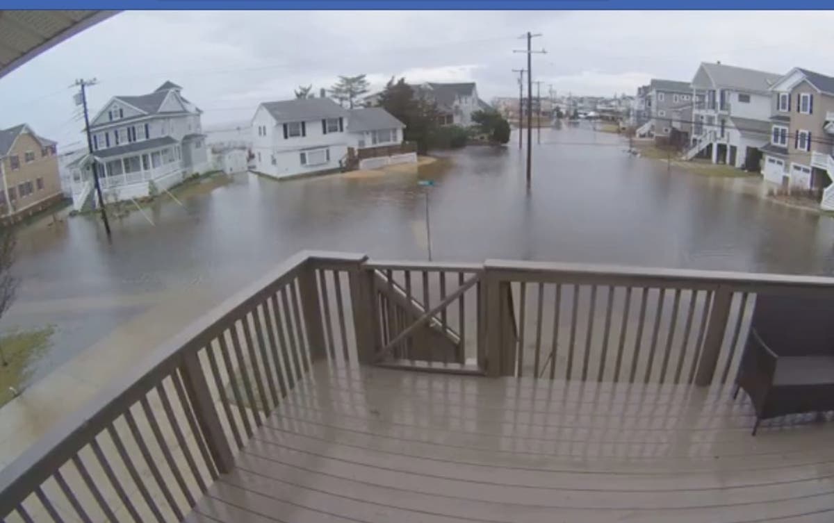
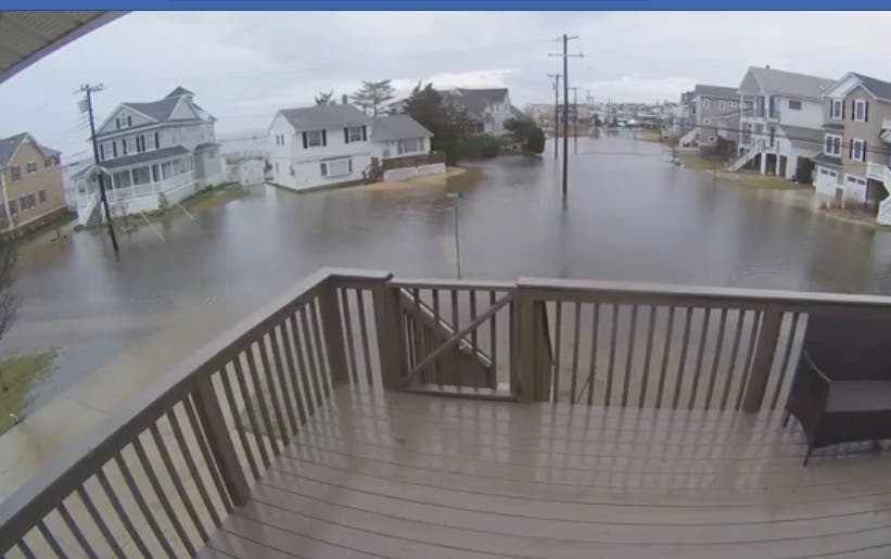
Flooding was reported in Long Beach Island, Ocean City and other parts of Cape May County.
Find out what's happening in Point Pleasantfor free with the latest updates from Patch.
Here are the areas without power:
- HOPATCONG BOROUGH 1,233
- RANDOLPH TOWNSHIP 603
- ROXBURY TOWNSHIP 359
- MORRIS TOWNSHIP 208
- HOPE TOWNSHIP 173
- BLAIRSTOWN TOWNSHIP 170
- Winslow Twp 133
- PARSIPPANY TROY HILLS TOWNSHIP 109
- GREEN TOWNSHIP 95
- ANDOVER TOWNSHIP 70
- HARDWICK TOWNSHIP 69
- Sea Isle City 41
- STILLWATER TOWNSHIP 37
- Pine Hill Boro 36
- MOUNT ARLINGTON BOROUGH 17
- GLEN ROCK BORO 13
- FRELINGHUYSEN TOWNSHIP 10
- MORRISTOWN TOWN 9
- SPARTA TOWNSHIP 6
- KNOWLTON TOWNSHIP 5
Here are the road impacts:
- US 1&9: Flooding on US 1&9 Truck Route northbound ramp to Hackensack Avenue in Kearny. Exit ramp closed.
- NJ 35: Flooding on NJ 35 southbound South of NJ 71/H Street in Belmar. All lanes closed and detoured follow detour, use caution.
- NJ 47: Flooding on NJ 47 in both directions north of CR 624/West Rio Grand Ave in Lower Twp. All lanes closed and detoured follow detour, use caution.
- US 40: Flooding on US 40 eastbound west of Atlantic City Expressway in Egg Harbor Twp. All lanes closed and detoured follow detour, use caution.
- US 40: Flooding on US 40 westbound West of Atlantic City Expressway in Egg Harbor Twp. 1 lane closed.
- I-80: Icing on I-80 eastbound from west of Exit 27 - NJ 183/US 206 in Mount Olive Twp to West of Exit 35 - Mount Hope Av in Rockaway Twp. Left lane use caution.
- Ben Franklin Bridge: Weather related closures on the Ben Franklin Bridge in both directions from New Jersey Side in Camden to Pennsylvania Side in Philadelphia. The North-Side Pedestrian Walkway will remain closed. Signs alerting the pedestrians of this temporary closure have been posted.
- New Jersey Turnpike: Roadway non-hazmat spill on the New Jersey Turnpike in both directions from Delaware Memorial Bridge in Pennsville Twp to North of Interchange 3 - NJ 168 in Barrington . District 1 conducting salting opeation.
- Garden State Parkway: Accident with Injuries on the Garden State Parkway northbound South of Exit 156 - US 46 in Clifton. Left and center lanes blocked.
- NJ 55: Accident on NJ 55 northbound North of Exit 53 - Woodbury Glassboro Rd in Deptford Twp. Right shoulder closed use caution.
- I-287: Truck restrictions on I-287 northbound between Exit 41 - I-80 in Parsippany-Troy Hills Twp and New York State Line in Mahwah Twp Commercial Vehicle Restriction.
Here are the alerted areas:
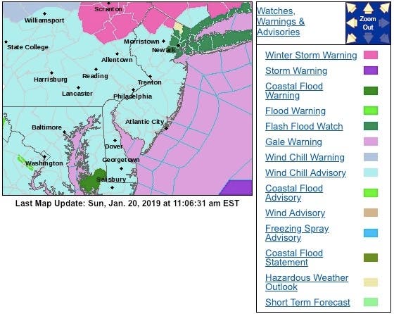
Here is the forecast:
- Sunday: Rain likely, mainly before 1pm. Mostly cloudy, with a temperature falling to around 26 by 5pm. Breezy, with a southwest wind 16 to 22 mph becoming northwest in the afternoon. Winds could gust as high as 37 mph. Chance of precipitation is 60%. New precipitation amounts of less than a tenth of an inch possible.
- Sunday night: Partly cloudy, with a low around 7. Wind chill values as low as -10. Blustery, with a northwest wind around 22 mph, with gusts as high as 37 mph.
- M.L.King Day: Sunny, with a high near 15. Wind chill values as low as -10. Blustery, with a northwest wind 20 to 23 mph, with gusts as high as 34 mph.
- Monday night: Mostly clear, with a low around 10. Wind chill values as low as -6. Blustery, with a northwest wind 11 to 20 mph.
Photo courtesy of Andrea Silver Palermo of flooding in Ocean City
Get more local news delivered straight to your inbox. Sign up for free Patch newsletters and alerts.


