Weather
Winter Storm Warning In 3 NJ Counties
UPDATE: A winter storm warning has been issued for three New Jersey counties as snow continues to fall. Here are the impacts.


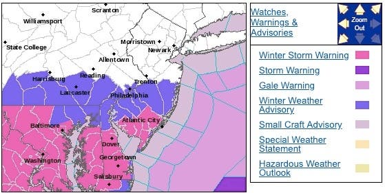
New Jersey has been dealing with slick roads and accidents as a winter storm warning has now been issued to three New Jersey counties. A winter weather advisory was issued for another five counties (see list of road impacts below).
The National Weather Service issued a winter storm warning to Cape May, Cumberland and Atlantic counties. The winter weather advisory was issued to Ocean, Camden, Burlington, Gloucester and Salem counties, saying snow accumulations of 1 to 6 inches are still expected by Monday morning.
More snow is expected to fall on Sunday, and could fall after 4 p.m. If the storm shifts to the north, as many as 9 inches could fall in in South Jersey, while the rest of the state could get 1 to 5 inches.
Find out what's happening in Point Pleasantfor free with the latest updates from Patch.
In Gloucester Township, Kearsley Road was closed between Sugarbush Drive and Parkview Drive because of a car crash that lead to a pole collapse, Gloucester Township police said early Sunday afternoon. Read more: Road Closed For Accident Involving Pole In Gloucester: Cops
Because of the government shutdown, the National Weather Service is not reporting snow totals except in areas where there is a winter storm warning. Rutgers University is reporting precipation amounts. Read more: New Jersey Snow Totals, Town-By-Town - 1/13/19The advisories are in effect until 4 a.m. on Monday, since the snow is expected to last until then. The snow could impact school schedules. Read more: New Jersey School Closings/Delayed Opening List For 1/14/19
Find out what's happening in Point Pleasantfor free with the latest updates from Patch.
- Heavy snow. Additional snow accumulations of 2 to 4 inches. This will result in total snow accumulations of 5 to 7 inches. A brief period of mixing to sleet and rain may occur by early this evening, then precipitation changes back to all snow before ending late tonight.
- Travel could be very difficult because of snow covered and slippery roads.
The weather is supposed to be cold, dropping into the teens and 20-degree range on Saturday night and Sunday. The National Weather Service, however, upped its totals now that appears that the storm has shifted to the north.
Now North and Central Jersey could get anywhere from 0 to 3 inches.
Here are the impacts to the roads, according to the state Department of Transportation:
- New Jersey Turnpike: Speed restrictions in both directions from Delaware Memorial Bridge in Pennsville Twp to north of Interchange 7A - I-195 in Robbinsville 45 miles per hour, for salting operations.
- Ben Franklin Bridge: Speed restrictions in both directions from New Jersey Side in Camden to Pennsylvania Side in Philadelphia. THE NORTH SIDE WALKWAY IS CLOSED UNTIL FURTHER NOTICE.
- Garden State Parkway: Speed restriction on the Garden State Parkway in both directions from Southern Terminus/CR 109 in Cape May to north of Exit 116 - PNC Arts Center in Holmdel Twp; 45 miles per hour due to salting operations.
- New Freedom Road was closed between Berlin-Clementon Road and Route 30 because of icy conditions, two accidents and a downed pole, Clementon police announced Saturday night. Read more: Icy Conditions Lead To 2 Accidents, Road Closure: Police
- I-287: Disabled tractor trailer on I-287 northbound north of Exit 12 - CR 623 in Bridgewater Twp. Right lane closed.
- I-295: Accident on I-295 southbound south of Exit 34 - NJ 70 in Cherry Hill Twp. Right lane closed use caution.
- Atlantic City Expressway: Speed restriction on the Atlantic City Expressway in both directions from Atlantic City Convention Center/Eastern Terminus in Atlantic City to Western Terminus - NJ 42 in Washington Twp speed limit reduced to 35 mph, use caution.
- US 22: Utility pole down on US 22 westbound at CR 509/Liberty Av in Hillside Twp. All lanes closed.
Here are the predicted snow totals:

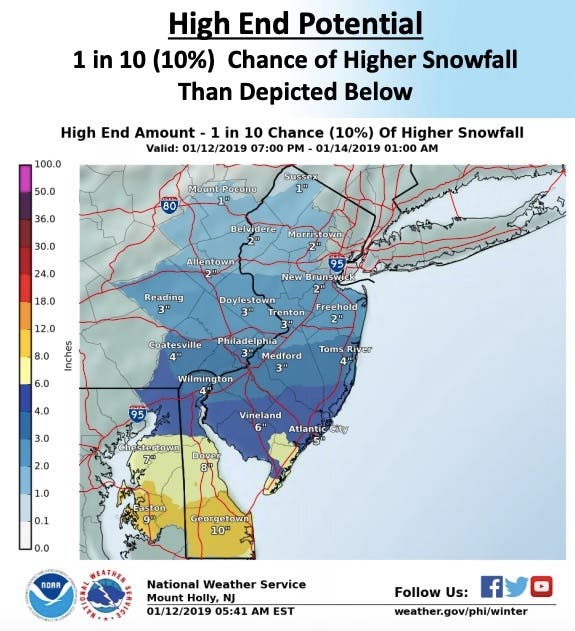
Here is what the NWS has specifically predicted:
- Snow will continue through this evening near and south of the I-476/I195 corridors before tapering off from northwest to southeast. Snow willbe moderate to heavy at times in Delmarva and southern New Jersey.
- For areas south of the Mason-Dixon Line: Snow totals of 4 to 7 inches with locally higher amounts possible are forecast in eastern Maryland, inland portions of central and southern Delaware, and far southern New Jersey. A mix of rain and sleet with the snow may cut down on total snowfall closer to the coast.
- For areas between the I-476/I-195 corridors and the Mason-Dixon Line: Up to four inches of snow may occur, with the highest totals closest to the Mason-Dixon Line. The snowfall forecast in this region is of low confidence, however, as a sharp decrease in total accumulation is expected from south to north.
- Coastal flooding is not expected with this system.
-1547391399-5923.jpg)
Here is the forecast for the areas where a winter weather advisory or winter storm warning was issued:
- Saturday: A chance of snow. Cloudy, with a high near 34. Northeast wind 9 to 13 mph. Chance of precipitation is 50%. Total daytime snow accumulation of around an inch possible.
- Saturday night: A chance of snow, mainly before 1am. Cloudy, with a low around 23. North wind around 14 mph. Chance of precipitation is 40%. New snow accumulation of less than a half inch possible.
- Monday: Partly sunny, with a high near 36. North wind 5 to 11 mph.
- Monday night: Mostly clear, with a low around 21. Northwest wind around 6 mph.
Gloucester Twp. police photo
NJDOT, Tom Davis and State Police photos
Get more local news delivered straight to your inbox. Sign up for free Patch newsletters and alerts.