Weather
Severe Thunderstorm Watch In 13 NJ Counties (UPDATED)
A severe thunderstorm watch was issued in 13 NJ counties; Hurricane Dorian is also still expected to have an impact in NJ. Here's where.


NEW JERSEY — The National Weather Service has issued a hazardous weather outlook across New Jersey ahead of potentially damaging storms Wednesday – just days before Hurricane Dorian is expected to have some impact at the Jersey Shore. A severe thunderstorm watch was issued in 13 New Jersey counties.
The watch is in effect until 9 p.m. Here are the alerted areas:
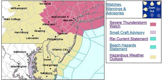
According to the NWS, storms during the afternoon and evening could produce locally strong to damaging winds. The storms could arrive after 3 to 4 p.m. Wednesday and linger through the evening. Wind gusts in the 20 mph range are possible, the NWS said.
Find out what's happening in Point Pleasantfor free with the latest updates from Patch.
Most of the storms are expected to happen in North Jersey, the NWS says.
Despite the chance of thunderstorms, temperatures will still be hot on Wednesday. The National Weather service predicts a high temperature of 87 degrees during the afternoon hours. The low temperature is an estimated 61 degrees for Wednesday night.
Find out what's happening in Point Pleasantfor free with the latest updates from Patch.
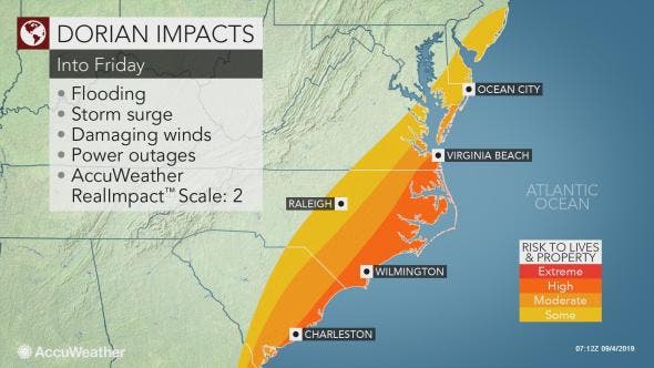
Meanwhile, Hurricane Dorian continues to batter Florida after having devastating impacts on the Bahamas. The storm is predicted to "make a prolonged crawl near or offshore from the East Coast" as the week progresses. By Friday night, the center of Dorian will move into the Atlantic Ocean.
Parts of the southern Jersey Shore could get heavy rain. Atlantic and Cape May counties could experience tropical storm-force winds between 8 p.m. on Thursday and 8 p.m. on Friday, the Weather Channel said.
Here is the forecast:
Today: Scattered showers and thunderstorms, mainly after 2pm. Partly sunny, with a high near 87. Southwest wind 7 to 11 mph, with gusts as high as 21 mph. Chance of precipitation is 30-50%. New rainfall amounts of less than a tenth of an inch, except higher amounts possible in thunderstorms.
Tonight: A chance of showers and thunderstorms before 9pm, then a slight chance of showers between 9pm and 11pm. Partly cloudy, with a low around 61. West wind around 7 mph becoming north after midnight. Chance of precipitation is 30-50%. New precipitation amounts of less than a tenth of an inch, except higher amounts possible in thunderstorms.
Thursday: Mostly sunny, with a high near 75. Northeast wind 3 to 7 mph.
Thursday Night: Mostly cloudy, with a low around 58. Northeast wind 3 to 6 mph.
Friday: A slight chance of rain after 2pm. Mostly cloudy, with a high near 70. Northeast wind 13 to 15 mph. Chance of precipitation is 20%.
Friday Night: Mostly cloudy, with a low around 54.
Get more local news delivered straight to your inbox. Sign up for free Patch newsletters and alerts.


