Crime & Safety
Forecasters: 2016 Hurricane Season Will Be Busier Than Usual
All eyes will be on the Atlantic Ocean in 2016 as forecasters say the hurricane season will be busier than usual.

All eyes will be on the Atlantic Ocean in 2016 as forecasters say the hurricane season will be busier than usual.
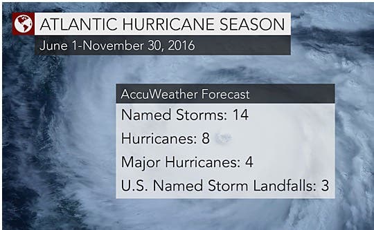
Forecasters are predicting that tropical storms and hurricanes in the Atlantic will total 14 this season, two more than what is considered normal, according to an AccuWeather release.
Forecasters identified several factors for their predictions:
Find out what's happening in Point Pleasantfor free with the latest updates from Patch.
If the cooler water migrates southward across the eastern Atlantic, then westward into tropical breeding grounds, it will lower sea-surface temperatures over the region where 85 percent of Atlantic tropical systems develop, according to AccuWeather.
The potential movement of a 'cold blob' of water in the North Atlantic Ocean also may be the wild card in the 2016 Atlantic hurricane season, experts say.
Find out what's happening in Point Pleasantfor free with the latest updates from Patch.
The cold blob refers to a large, anomalous area of colder-than-normal sea-surface temperatures, located east of Newfoundland and south of Greenland.
"This area of colder water started to show up a few years ago and has become larger and more persistent during the past couple of years," AccuWeather Atlantic Hurricane Expert Dan Kottlowski said in the release.
Whether or not ocean currents draw cold water from this blob southward into tropical regions of the Atlantic could determine how active the season becomes.
Another possibility is that the water from the cold blob could alter the makeup of deep ocean currents and affect the salinity of the water.
If this happens, the pattern of warming waters that has been occurring since 1995 will reverse, leading to a period of cooling, according to AccuWeather.
If these scenarios don't occur, sea-surface temperatures will remain mostly warmer than normal, likely resulting in a season more active than in the past three years.
Should this be the case, experts believe the current El Niño will weaken, eventually leading to a neutral pattern by the end of the spring or early summer.
"The big question is whether we will go into a La Niña, which is what we're anticipating right now," Kottlowski said.
La Niña is characterized by cooler-than-normal ocean water temperatures in the Pacific Ocean near the Equator.
"Historically, some hurricane seasons that have followed a transition from El Niño to La Niña have been very active. It's possible we could flip from one extreme to the other, from below-normal seasons the past three years to an above-normal year in 2016," he said.
Get more local news delivered straight to your inbox. Sign up for free Patch newsletters and alerts.