Weather
Forecasters Eyeing Potential Weekend Nor'easter: NJ Weather
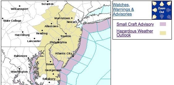
A hazardous weather outlook has been issued now that a nor'easter could threaten New Jersey by Halloween.


The biggest storm of the fall season thus far could be coming to New Jersey by Halloween, arriving in the form of a nor'easter packing strong winds and heavy rain.
A hazardous weather outlook has been issued for all of New Jersey even as the National Weather Service says the agency won't know the storm's impact – or even if it will come – until Wednesday or Thursday.
A coastal low pressure system is expected to impact the region this weekend, bringing with it the potential for strong winds, coastal flooding and heavy rain that may result in localized freshwater flooding, according to the NWS.
Find out what's happening in Point Pleasantfor free with the latest updates from Patch.
Snow is even possible – though not likely – in the highest elevation areas of Sussex County and the Poconos, said Trent Davis, an NWS meteorologist.
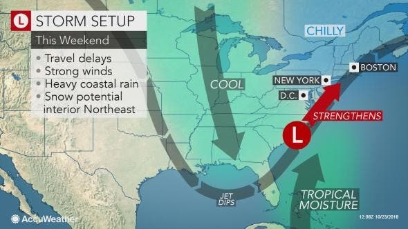
The storms apparently originated in the form of Hurricane Willa, which is expected to move across Mexico in midweek, AccuWeather Meteorologist Evan Duffey said in a release. A batch of tropical moisture, or a more potent tropical rainstorm, is then forecast to push eastward across the northern Gulf coast.
Find out what's happening in Point Pleasantfor free with the latest updates from Patch.
Then a new storm born from the moisture may make a northward turn along the Atlantic coast this weekend as a potential nor'easter, Duffey said in the release. There is the likelihood of substantial travel delays and disruptions to outdoor activities from the mid-Atlantic coast to New England.
"A period of heavy rain is most likely along the coast. Coastal areas may have to contend with beach erosion and flooding at time of high tide. Wet snow is possible over the higher terrain across the interior. Impacts from gusty winds from the strengthening storm could be a factor throughout the region," Duffey said in the release.
Here are the alerted areas:
Here is the forecast:
- Tuesday: Mostly sunny, with a high near 64. Southwest wind 6 to 10 mph, with gusts as high as 22 mph.
- Tuesday nightPartly cloudy, with a low around 41. West wind around 9 mph, with gusts as high as 23 mph.
- Wednesday: Mostly sunny, with a high near 55. Northwest wind 11 to 15 mph, with gusts as high as 25 mph.
- Wednesday night: Mostly clear, with a low around 33. Northwest wind around 11 mph.
- Thursday: Sunny, with a high near 51. Northwest wind 9 to 11 mph.
- Thursday night: Partly cloudy, with a low around 30.
- Friday: Partly sunny, with a high near 50.
- Friday night: A chance of rain. Cloudy, with a low around 39. Breezy. Chance of precipitation is 40%.
- Saturday: Rain likely. Cloudy, with a high near 51. Breezy. Chance of precipitation is 60%.
- Saturday night: A chance of rain. Cloudy, with a low around 41. Chance of precipitation is 50%.
- Sunday:A chance of showers. Mostly cloudy, with a high near 52. Chance of precipitation is 40%.
- Sunday night: A chance of showers. Mostly cloudy, with a low around 40. Chance of precipitation is 40%.
- Monday: A chance of showers. Mostly cloudy, with a high near 54. Chance of precipitation is 40%.
Tom Davis photos
Get more local news delivered straight to your inbox. Sign up for free Patch newsletters and alerts.


