Weather
Hazardous Weather Outlook For Winter Weather, Possible Snow In NJ
The National Weather Service has issued an alert now that there are two chances for winter weather – and one storm could be rough.


Now the National Weather Service has issued an alert for what could be the trickiest winter weather New Jersey has had in weeks.
The NWS has issued a hazardous weather outlook for the whole state, saying a wintry mix of snow, sleet, and freezing rain will develop late Monday night and continue through Tuesday.
There is the potential for a prolonged period of wintry weather Tuesday and Tuesday night, with impacts to the morning and evening commutes possible, according to the NWS.
Find out what's happening in Point Pleasantfor free with the latest updates from Patch.
This will happen after a possible snowfall on Sunday night, the NWS says.
The weather could change school schedules on Monday and Tuesday. Read more: New Jersey School Closings/Delays List For Monday And Tuesday
Find out what's happening in Point Pleasantfor free with the latest updates from Patch.
Here is what is expected:
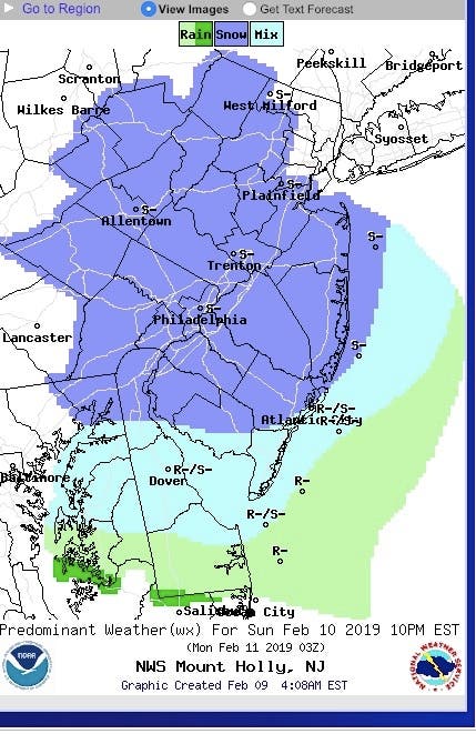
- No more than 1 to 2 inches of snow should fall on Sunday night, beginning sometime before or after 10 p.m.:
![]()
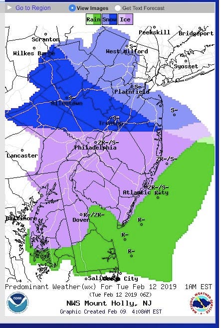
- The worst weather is expected to arrive on Monday night and Tuesday, coming in the form of snow and a wintry mix, by 1 a.m. Tuesday:
![]()
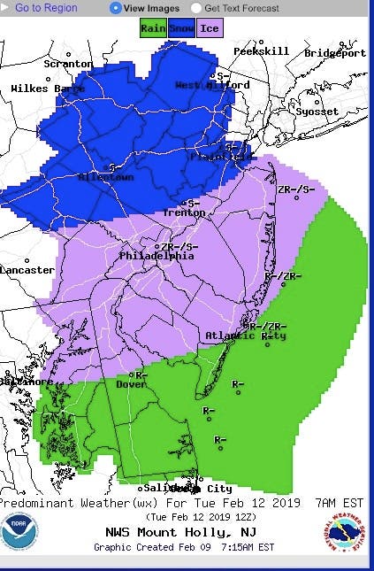
- That rough weather could continue to Tuesday morning and impact the commute. School could be impacted again:
![]()
AccuWeather says two storms with some snow and ice will bring difficult travel and are likely to prompt school delays and closings across the Midwest and Northeast from Sunday to Tuesday. The storms from later this weekend through the middle of next week will create travel problems, even where rain falls, according to AccuWeather.
The first storm will be the weaker of the two. Because of that, it is the least likely of the two to pull warm air up from the south very far, according to AccuWeather. "Since the storm late this past week washed away much of the salt from the roads, crews may have to work extra hard reapplying ice melting compounds in this extensive area of snow forecast," AccuWeather Chief Meteorologist Elliot Abrams said in a release.
"Roads and sidewalks might be slipperier than you would normally expect from a light snowfall at this point of the winter and motorists, pedestrians and property owners should plan accordingly," Abrams said in the release.
-1549724897-2252.jpg)
The second storm of next week is forecast to be significantly stronger, more complex and may travel well to the north in the cold air with heavy precipitation, according to AccuWeather.
"In the Midwest, the second storm will be primarily from Monday to Tuesday evening," AccuWeather Senior Meteorologist Brett Anderson said in the release. "In the Northeast, the second storm may begin as early as Monday night in the central Appalachians but will occur mainly from Tuesday to early Wednesday."
Arctic high pressure will linger over New England and not quickly exit by way of the mid-Atlantic coast, according to AccuWeather. So despite the rapid warmup suggestion by a storm cutting toward the Great Lakes, a period of heavy snow and a substantial buildup of ice can occur in parts of the Northeast, according to AccuWeather.
"There may be several inches of snow from parts of southern Michigan, Pennsylvania and New York state to Massachusetts prior to any change to ice and rain," Abrams said in the release.
-1549725048-546.jpg)
Here is the forecast:
- Saturday: Sunny, with a high near 33. Northwest wind 10 to 16 mph, with gusts as high as 29 mph.
- Saturday night: Clear, with a low around 16. Northwest wind 3 to 6 mph.
- Sunday: Mostly sunny, with a high near 37. West wind 3 to 6 mph.
- Sunday night: A chance of snow. Mostly cloudy, with a low around 26. Light and variable wind. Chance of precipitation is 40%. New snow accumulation of less than a half inch possible.
- Monday: A slight chance of rain and snow after 1pm. Mostly cloudy, with a high near 38. Calm wind becoming northeast around 5 mph in the morning. Chance of precipitation is 20%.
- Monday night: A chance of snow or rain. Cloudy, with a low around 25. Chance of precipitation is 50%.
- Tuesday: Snow or rain before 10am, then snow, freezing rain, and sleet between 10am and 1pm, then rain, snow, and sleet after 1pm. High near 36. Chance of precipitation is 90%.
- Tuesday night: Freezing rain and sleet before 4am, then snow, freezing rain, and sleet likely. Low around 31. Chance of precipitation is 80%.
- Wednesday: Snow possible before 7am. Partly sunny, with a high near 44. Chance of precipitation is 60%.
Patch photos
Get more local news delivered straight to your inbox. Sign up for free Patch newsletters and alerts.


