Weather
Hurricane Dorian Turns North: What Does This Mean For NJ?
UPDATE: Here is what forecasters are saying about the potential impact Hurricane Dorian could have on NJ. And it's surprising.

You may scoff at the idea of Hurricane Dorian coming to New Jersey. But with its shift in track, it's becoming a lot more possible that the major storm could impact on the Garden State.
Gary Szatkowski, who served as meteorologist for the National Weather Service, said long-period swells from Dorian are forecast to start affecting the New Jersey coastline on Sunday.
"Pay close attention to surf conditions over this holiday weekend and heed instructions from local lifeguards," he said.
Find out what's happening in Point Pleasantfor free with the latest updates from Patch.
And Joe Martucci, a meteorologist with The Press of Atlantic City, tweeted that "there's always been a likelihood of a side swipe" in New Jersey and "that risk is increasing for late next week."
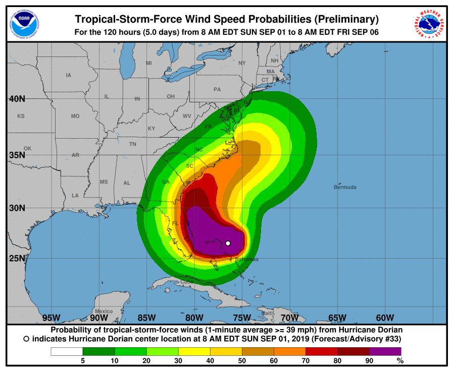
Indeed, the National Hurricane Center's graphics shows winds from the storm impacting parts of New Jersey by late Thursday:
Find out what's happening in Point Pleasantfor free with the latest updates from Patch.

The "cone of uncertainty" now extends just below Cape May:
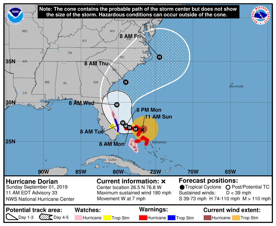
And tropical-storm force winds could impact New Jersey, according to the NHC.
Martucci said a fast-moving high pressure system will likely push Dorian out to sea. But if the pressure system moves slowly, Dorian could travel north and impact New Jersey just as Hurricanes Irene and Floyd did in 2011 and 1999, respectively.

Here is the forecast right now:
- Sunday: Partly sunny, with a high near 79. East wind 6 to 9 mph.
- Sunday night: Mostly cloudy, with a low around 65. East wind 3 to 5 mph.
- Labor Day: A slight chance of showers, then a chance of showers and thunderstorms after 2pm. Partly sunny, with a high near 82. South wind 3 to 8 mph. Chance of precipitation is 30%.
- Monday night: A chance of showers and thunderstorms before 2am, then a slight chance of showers. Mostly cloudy, with a low around 66. South wind around 6 mph becoming calm in the evening. Chance of precipitation is 30%. New rainfall amounts of less than a tenth of an inch, except higher amounts possible in thunderstorms.
- Tuesday: Mostly sunny, with a high near 83.
- Tuesday night: Mostly clear, with a low around 68.
- Wednesday: Mostly sunny, with a high near 86.
- Wednesday night: A chance of showers, with thunderstorms also possible after 8pm. Mostly cloudy, with a low around 64. Chance of precipitation is 30%.
- Thursday: Mostly cloudy, with a high near 73.
- Thursday night: Mostly cloudy, with a low around 60.
- Friday: A chance of showers. Mostly cloudy, with a high near 75. Breezy. Chance of precipitation is 30%.
- Friday night: A chance of showers. Mostly cloudy, with a low around 59. Chance of precipitation is 30%.
Get more local news delivered straight to your inbox. Sign up for free Patch newsletters and alerts.