Weather
Hurricane Jose: Tropical Storm Watch For 5 New Jersey Counties
Hurricane Jose presents enough of a threat to New Jersey that the National Weather Service has issued an alert.


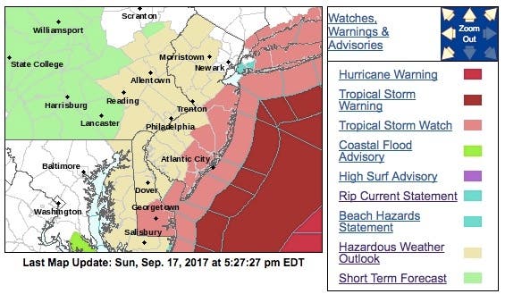
The track of the storm has shifted to the east, but Hurricane Jose still presents enough of a threat that the National Weather Service has issued a tropical storm watch for 5 New Jersey counties.
The counties under the watch are Monmouth, Ocean, eastern Burlington, Atlantic and Cape May. The rest of New Jersey has received a hazardous weather outlook alert. The storm is expected to impact the area beginning on Tuesday.
Hurricane Jose, packing 85 mph winds, is still on a track that could impact the East Coast. But the track has shifted in a way that should bring at least some relief to New Jersey residents.
Find out what's happening in Point Pleasantfor free with the latest updates from Patch.
The National Hurricane Center says the Category 1 hurricane is expected now to mostly veer away from New Jersey and have its biggest impact on New England, particularly Cape Cod.
New Jersey, however, is still expected to get rain, gusty winds and perhaps some flooding from the storm mid-week. Some of the outer bands of the storm are expected to pass over the state.
Find out what's happening in Point Pleasantfor free with the latest updates from Patch.
Read more: Shift In Hurricane Jose Track: What It Means For New Jersey
Here is what the National Weather Service says could happen in New Jersey:
WIND
- LATEST LOCAL FORECAST: Peak Wind Forecast: 20-30 mph with gusts to 45 mph
- CURRENT THREAT TO LIFE AND PROPERTY: Elevated
- Emergency planning should include a reasonable threat for tropical storm force wind of 39 to 57 mph.
- To be safe, prepare for the potential of limited wind impacts. Efforts should now be underway to secure all properties.
- Hazardous wind is possible. Failure to adequately shelter may result in serious injury.
- Damage to porches, awnings, carports, sheds, and unanchored mobile homes is possible. Unsecured lightweight objects could be blown around.
- Many large tree limbs may be broken off. A few trees could be snapped or uprooted. Some fences and roadway signs may be blown over.
- A few roads could be impassable from debris. Hazardous driving conditions are possible on bridges and other elevated roadways.
- Scattered power and communications outages are possible.
STORM SURGE
- LATEST LOCAL FORECAST: Not available at this time. To be updated shortly.
- Threat to life and property: Not available at this time. To be updated shortly.
- POTENTIAL IMPACTS: Not available at this time. To be updated shortly.
FLOODING RAIN
- LATEST LOCAL FORECAST: Peak rainfall amounts: 1-3 inches, with locally higher amounts
- CURRENT THREAT TO LIFE AND PROPERTY: Elevated
- Emergency planning should include a reasonable threat for minor flooding where peak rainfall totals are near amounts conducive for localized flash flooding and rapid inundation.
- To be safe, prepare for the potential of limited flooding rain impacts.
- Localized flooding is possible. If flood related watches and warnings are issued, heed recommended actions.
- POTENTIAL IMPACTS: Limited
- Localized rainfall flooding may prompt a few evacuations.
- Rivers and tributaries may quickly rise with swifter currents. Small streams, creeks, canals, and ditches may become swollen and overflow in spots.
- Flood waters can enter a few structures, especially in vulnerable spots. Rapid ponding of water may occur at underpasses, low-lying spots, and poor drainage areas. Several storm drains and retention ponds become near-full and begin to overflow. Some brief road and bridge closures are possible.
TORNADO
- LATEST LOCAL FORECAST: Situation is unfavorable for tornadoes
- CURRENT THREAT TO LIFE AND PROPERTY: None
- Emergency planning need not include a threat for tornadoes. Showers and thunderstorms with strong gusty winds may still occur.
- Little to no preparations needed to guard against tropical tornadoes. Ensure readiness for the next tropical tornado event.
* FOR MORE INFORMATION:
- http://www.weather.gov/phi
Also See: Another Hurricane Could Be Headed Toward The Caribbean
Photo: A beachgoer walks along the water as waves crash in Manasquan, N.J., Thursday, Sept. 14, 2017. Swells are up from recent hurricanes in the Atlantic Ocean, including Tropical Storm Jose, which could impact New Jersey, according to meteorologists. (AP Photo/Julio Cortez)
Get more local news delivered straight to your inbox. Sign up for free Patch newsletters and alerts.


