Weather
3K Lose Power In NJ: Severe Thunderstorm Warnings In 3 Counties
The National Weather Service says more severe weather is possible in New Jersey. Here's when.


NEW JERSEY – A day after storms hit the region, more severe weather hit New Jersey overnight. Nearly 3,000 peeople were without power early Friday (see list of towns below)
The NWS issued a hazardous weather outlook for all of New Jersey, saying there was a chance of thunderstorms capable of producing locally strong wind gusts, heavy rainfall and localized flooding late Thursday and early Friday.
The power companies said they hoped to restore pwer by 2:30 p.m.
Find out what's happening in Point Pleasantfor free with the latest updates from Patch.
Here are the towns that lost power:
- METUCHEN BORO 689
- OLD TAPPAN BORO 318
- MORRIS TOWNSHIP 313
- EAST BRUNSWICK TWP 226
- RIVER VALE TWP 164
- MORRISTOWN TOWN 127
- NORTH CALDWELL BORO 104
- Shamong Twp 98
- EDISON TWP 96
- TEANECK TWP 95
- Lower Twp 83
- WEST NEW YORK TOWN 64
- EAST ORANGE CITY 63
- HOWELL TOWNSHIP 57
- Monroe Twp 47
- NEWARK CITY 43
- CHATHAM TOWNSHIP 36
- CEDAR GROVE TWP 35
- BELLEVILLE TWP 30
- Upper Pittsgrove Twp 19
- SOUTH ORANGE VILLAGE TWP 16
- SAYREVILLE BOROUGH 15
- BLOOMFIELD TWP 13
- NORTH HALEDON BORO 13
- MENDHAM TOWNSHIP 10
- LEBANON TOWNSHIP 9
- WALL TOWNSHIP 8
- CHATHAM BOROUGH 7
- PARAMUS BORO 6
- MONTVILLE TOWNSHIP 6
- MOUNT OLIVE TOWNSHIP 6
- FLORHAM PARK BOROUGH 5
The National Weather Service says there is a marginal risk for storms happening overnight (see forecast below). Gusty winds, brief heavy downpours, and frequent lightning were possible with this line of storms.
Find out what's happening in Point Pleasantfor free with the latest updates from Patch.
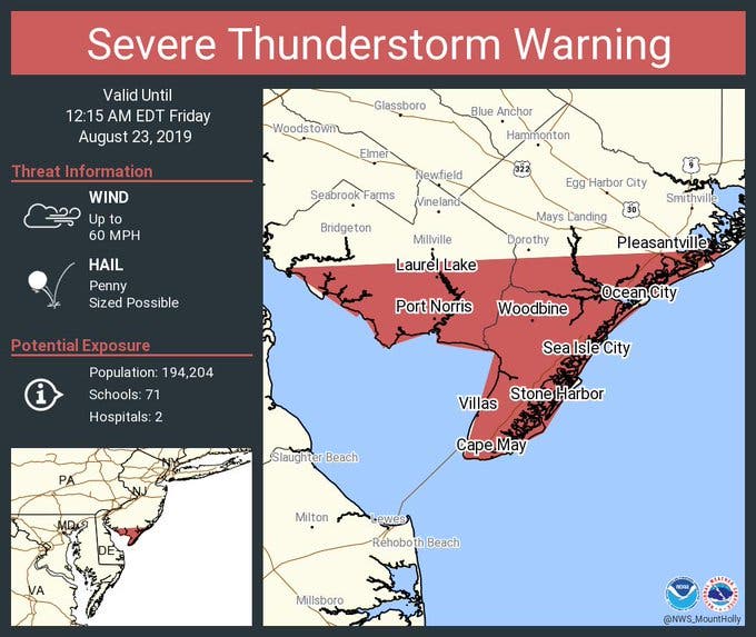
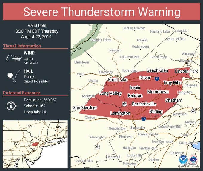
Severe thunderstorm warnings were issued in several New Jersey counties.
AccuWeather says those storms could be largely concentrated in North Jersey.
From Thursday to the first part of Friday, a weak storm system is expected to move eastward along the press of cool air, according to AccuWeather.
Showers are likely just north of the storm track, while heavy, gusty and severe thunderstorms can occur in the warm and humid air, according to AccuWeather.
However, from later Friday to Saturday, cooler and less humid conditions are likely to push farther to the south and east, according to AccuWeather. People who have difficulty with hot and humid weather and are forced to limit time outdoors will be able to enjoy the weather and get some fresh air this weekend.
.jpeg)
Here is the forecast:
- Thursday afternoon: Partly sunny, with a high near 88. West wind around 7 mph.
- Thursday night: Showers and thunderstorms likely, mainly between 1am and 2am. Some of the storms could produce gusty winds and heavy rain. Cloudy, with a low around 65. West wind 3 to 5 mph. Chance of precipitation is 60%. New rainfall amounts between a quarter and half of an inch possible.
- Friday: A slight chance of showers before 8am, then a slight chance of showers and thunderstorms between 8am and 2pm. Partly sunny, with a high near 80. North wind around 7 mph. Chance of precipitation is 20%.
- Friday Night: Partly cloudy, with a low around 56. North wind 5 to 7 mph.
- Saturday: Mostly sunny, with a high near 79. North wind 6 to 8 mph.
- Saturday night: Partly cloudy, with a low around 59.
Get more local news delivered straight to your inbox. Sign up for free Patch newsletters and alerts.


