Weather
NJ Weather: Winter Weather Advisory, April Snow Estimates Rise
Again, no April fool's joke: 3 to 6 inches expected in some areas. See who's supposed to get it the worst, and when. Snow estimates, too.


Yes, they're sticking with it. And now, the predictions have gotten worse for the surprise April snow (see snow estimates below).
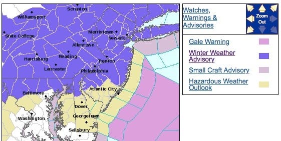
A winter weather advisory is in effect for almost all New Jersey, leaving out just a few of the southern counties. So have a merry little post-Easter since as many as 3 to 6 inches could fall in spots, according to the National Weather Service. Already, the snow was having an impact on roads (see below).
Already, as many as 5 inches have fallen in parts of the state. Read more: New Jersey Snow Totals, Town-By-Town - 4/2/18
Find out what's happening in Point Pleasantfor free with the latest updates from Patch.
The National Weather Service has even released a briefing package for the unseasonable weather, including a county-by-county forecast for the state. Read more: NJ Weather: Hour-By-Hour Forecast Of Surprise April Snow
The NWS says "widespread accumulating snow" on Monday could result in sloppy, hazardous travel for the Monday morning commute. An inch per hour could fall in spots (see road conditions below).
Find out what's happening in Point Pleasantfor free with the latest updates from Patch.
The forecast was enough to cause schools to delay openings, and some even closed on Monday. Many – if not most – school districts are on spring break this week, though some had to add school time to make up for snow days. Read more: New Jersey School Closings/Delays List For 4/2/18
While no cancellations are currently being reported at Newark Liberty International Airport, the weather could affect flights. Confirm your flight status with your airline before arriving at Newark.
Here are the alerted areas:
Basically, the NWS says winter isn't through with us – so much so that April 2018 could make the list of top-10 snowiest Aprils just from this event alone.
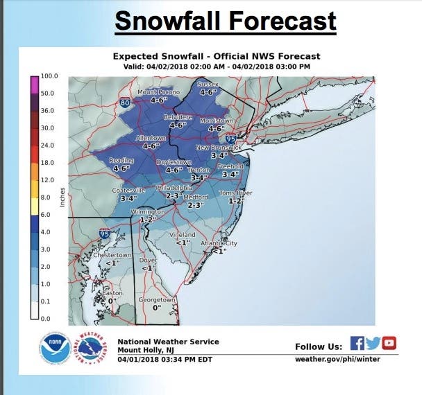
Here are the expected snow totals:
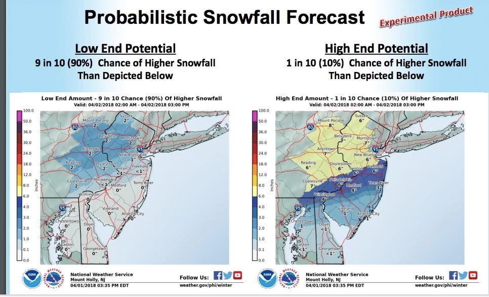
Here are the high- and low-end estimates:
Here are the estimates for the New York area:

Here were the road conditions at 6 a.m.:
- New Jersey Turnpike: Speed restriction on the New Jersey Turnpike in both directions from south of Interchange 6 - Pennsylvania Turnpike in Mansfield Twp to George Washington Bridge in Fort Lee 45 miles per hour, due to Salting Operations.
- Garden State Parkway: Speed restriction on the Garden State Parkway in both directions from north of Exit 77 - Berkeley in Beachwood to North of Exit 90 - CR 549/Chambers Bridge Rd in Brick Twp . Ocean maintenance conducting salting operation. Speed limit is 45. VMS in use.
- Outerbridge Crossing: Speed restriction on the Outerbridge Crossing in both directions between New Jersey side in Perth Amboy and New York side in Staten Island . Speed restriction of 30 miles per hour.
- Garden State Parkway: Speed restriction on the Garden State Parkway in both directions from north of Exit 105 - NJ 36 in Tinton Falls to Exit 143C - NJ 124 in Irvington Twp 45 miles per hour, due to Salting Operations.
- Garden State Parkway: Speed restriction on the Garden State Parkway in both directions from Exit 143C - NJ 124 in Irvington Twp to New York State Line in Montvale 35 miles per hour salting and plowing operations.
- Palisades Interstate Parkway: Accident on the Palisades Interstate Parkway northbound north of Exit 1 - Palisade Avenue in Englewood Cliffs. All lanes temporarily closed.
- NJ 21: Overturned vehicle on NJ 21 northbound area of Chester Av in Newark. Right and center lanes closed 5-10 minute delay.
- I-78: Accident on I-78 eastbound West of Exit 4 - CR 637/Stewartsville-Bloomsbury Rd in Greenwich Twp. Left lane closed 5-10 minute delay.
- I-78: Accident on I-78 westbound East of Exit 29 - I-287/US 202/US 206 in Bedminster Twp. Left lane closed.
- Goethals Bridge: Speed restriction on the Goethals Bridge in both directions from New Jersey side in Elizabeth to New York side in Staten Island of 30 miles per hour due to long term construction.
Here is what could happen:
- Total snow accumulations of 1 to 6 inches are expected, with locally 6 inches possible.
- A brief wintry mix in some areas develops and quickly changes to snow between about midnight and 3 a.m. Monday, then snow continues moderate to potentially heavy at times during the morning before tapering off around midday. Snowfall rates of 1 to 2 inches per hour may occur at times between about 4 a.m. and 9 a.m. Monday.
- Plan on difficult travel conditions, including during the Monday morning commute. Expect reduced visibilities at times. The snowfall rates will significantly affect how much snow accumulates on roadways, as rates at or greater than an inch per hour, with temperatures near freezing, will result in untreated roads becoming slushy to snow covered.
- High temperatures Monday afternoon in the 40s will lead to rapid melting.
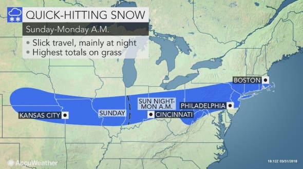
The band of accumulating snow may be no more than 100 miles wide, so a 50-mile shift in the storm track could mean the difference between several inches of snow, rain or dry weather, according to AccuWeather.
Slippery travel and snow-covered roadways will again become an issue from the Ohio Valley to the mid-Atlantic, where most of the snow should fall on Sunday night. Motorists will not be the only ones impacted, according to AccuWeather. Flights in and out of Indianapolis; Pittsburgh, Harrisburg, Allentown and Philadelphia, Pennsylvania, could face delays and cancellations Sunday evening through Monday morning.
Higher traffic volume is expected this Easter weekend, so those in the path of the storm should allot extra time to get to their destinations and be prepared for adverse, rapidly-changing weather conditions, according to AccuWeather. Large portions of interstates 29, 35, 70, 75, 80 and 95 lie in the path of the storm.
Here is the forecast:
- Monday: Rain and snow, becoming all rain after 11am, then gradually ending. High near 47. Light and variable wind becoming northwest around 5 mph in the afternoon. Chance of precipitation is 80%. New snow accumulation of 1 to 3 inches possible.
- Monday night: A chance of rain after 2am. Mostly cloudy, with a low around 33. Light south wind. Chance of precipitation is 40%. New precipitation amounts of less than a tenth of an inch possible.
- Tuesday: Rain and snow likely, becoming all rain after 9am. Cloudy, with a high near 48. Southeast wind 3 to 8 mph. Chance of precipitation is 70%. Little or no snow accumulation expected.
Shutterstock photo
Get more local news delivered straight to your inbox. Sign up for free Patch newsletters and alerts.


