Weather
NJ Weather: Hurricane Florence Impacts, 6 Inches Of Rain Possible
Strong winds, thunderstorms and heavy rain are supposed to turn toward New Jersey. Here's when and where.


Strong winds, thunderstorms and up to 6 inches rain are possible in New Jersey this week as Hurricane Florence impacts are expected to come our way.
The National Weather Service has issued a hazardous weather outlook throughout the state, saying there is the potential for a period of moderate to heavy rainfall later Monday into Tuesday as the remnants of Florence move across the Northeast, which could lead to some areas of flooding.
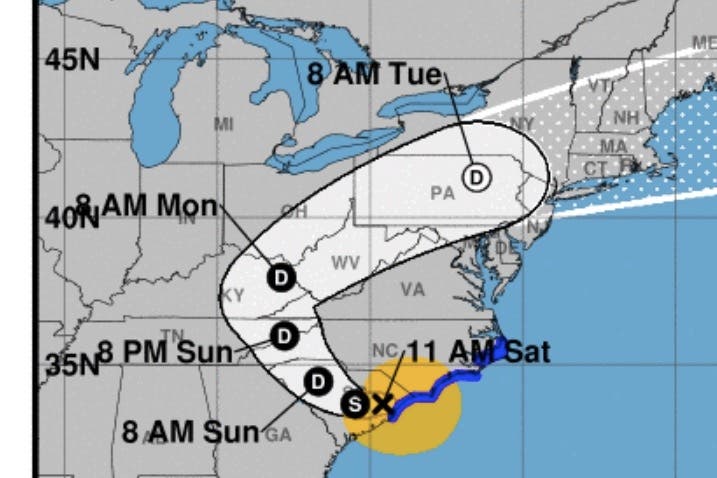
Indeed, New Jersey is now in the storm's "cone of uncertainty," showing that a tropical depression with wind speeds up to 39 mph is possible, according to the National Hurricane Center. Anywhere from 3 to 6 inches of rain are possible.
Find out what's happening in Point Pleasantfor free with the latest updates from Patch.
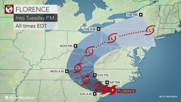
While Florence will spend days in the South, the storm will survive long enough to bring rounds of heavy rain and the risk of flooding to the central Appalachians and northeastern United States next week, according to AccuWeather.
Areas in the West Virginia, northern Virginia, western Maryland, New Jersey and Pennsylvania are likely the most vulnerable for flash and stream flooding because of the saturated state of the ground, proximity to tropical moisture and the terrain, according to AccuWeather.
Find out what's happening in Point Pleasantfor free with the latest updates from Patch.
However, enough rain may fall to cause flash and urban flooding throughout the swath.
"While those living in the Appalachians should monitor Florence’s track, the center of the system may not track right over the mountains, rather it could track either west or east of the mountains," AccuWeather Meteorologist Courtney Spamer said in a release.
"Because of this, residents from the Ohio Valley to the mid-Atlantic and New England coasts should be prepared in case of tropically-enhanced rain and flooding occurring next week."
The mitigating factor will be the exact track of the core of the torrential downpours and increasing forward speed the downpours take.
A mere 1-2 inches of rain in six hours or less could be enough to initiate flash flooding from northern West Virginia and northwestern Virginia to southern New York state and western New England.
Here is the forecast:
- Saturday: Mostly sunny, with a high near 76. East wind around 8 mph.
- Saturday night: Patchy fog after 2am. Otherwise, partly cloudy, with a low around 63. Northeast wind 3 to 5 mph.
- Sunday: Patchy fog before 8am. Otherwise, mostly sunny, with a high near 79. Northeast wind 5 to 7 mph.
- Sunday night: Partly cloudy, with a low around 64. East wind 3 to 5 mph.
- Monday: A chance of showers and thunderstorms, mainly after 2pm. Some of the storms could produce heavy rain. Mostly cloudy, with a high near 80. South wind 3 to 7 mph. Chance of precipitation is 30%. New rainfall amounts of less than a tenth of an inch, except higher amounts possible in thunderstorms.
- Monday night: A chance of showers and thunderstorms, then showers likely and possibly a thunderstorm after 8pm. Some of the storms could produce heavy rain. Cloudy, with a low around 69. Chance of precipitation is 70%. New rainfall amounts between a quarter and half of an inch possible.
- Tuesday: Showers likely and possibly a thunderstorm. Some of the storms could produce heavy rain. Cloudy, with a high near 81. Chance of precipitation is 70%.
- Tuesday night: A chance of showers. Partly cloudy, with a low around 66. Chance of precipitation is 40%.
Tom Davis photo
Get more local news delivered straight to your inbox. Sign up for free Patch newsletters and alerts.


