Weather
NJ Weather Forecast: Storms Ahead Of Mother's Day Weekend
The weather has been good thus far this week. Well, that will be changing quickly. A hazardous weather outlook has been issued.


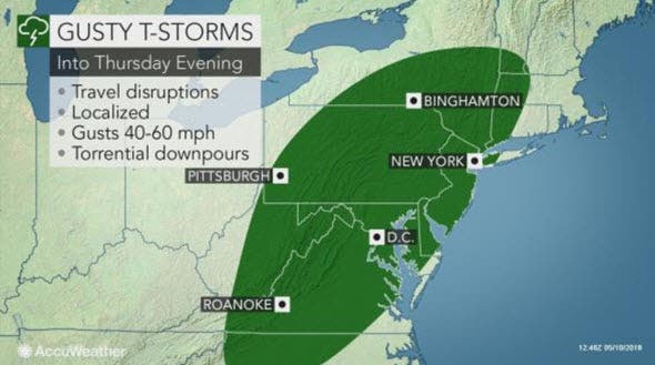
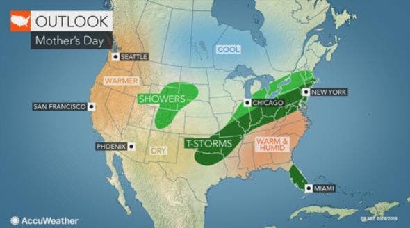
Mother's Day 2018 is expected to be a typical spring day across most of the United States – except for New Jersey and some neighboring areas. One or more rounds of gusty thunderstorms with 40-60 mph winds will rumble through a large part of the eastern United States into Thursday evening.
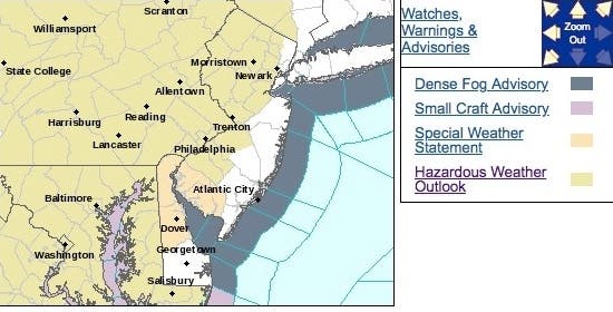
A hazardous weather outlook has been issued in most of New Jersey since the threat of rain and thunderstorms may discourage outdoor events and prevent restaurants from opening up outdoor seating in much of New Jersey, according to forecasters.
The bad weather is supposed to start Thursday, with scattered thunderstorms anticipated. A few of these storms may become severe with the potential to produce damaging winds and large hail. The greatest risk for severe thunderstorms will be from 4 to 8 p.m., according to the National Weather Service.
Find out what's happening in Point Pleasantfor free with the latest updates from Patch.
Here are the alerted areas:
The greatest concentration of the Thursday storms will extend from western and central North Carolina to upstate New York and southwestern New England. This is the same system that produced more than 50 reports of severe weather over the Midwest on Wednesday.
Find out what's happening in Point Pleasantfor free with the latest updates from Patch.
The main impact from the storms in the East is likely to be disruptions to daily activities and travel. An umbrella and pair of waterproof shoes will be a necessity for pedestrians and commuters.
Temperatures will be spring-like, according to AccuWeather Senior Meteorologist Alex Sosnowski, but a swath of rain and thunderstorms is likely.
Enough rain may fall to washout outdoor plans and require an umbrella and waterproof shoes for trip to the restaurant. However, it is not likely to rain the entire day.
Here is the forecast:
- Thursday: A slight chance of showers, then a chance of showers and thunderstorms after 2pm. Some of the storms could produce gusty winds. Mostly cloudy, with a high near 78. Light south wind becoming southwest 8 to 13 mph in the morning. Chance of precipitation is 30%. New rainfall amounts of less than a tenth of an inch, except higher amounts possible in thunderstorms.
- Thursday night: A chance of showers and thunderstorms before 9pm, then a slight chance of showers between 9pm and 10pm. Some of the storms could produce gusty winds. Mostly cloudy, then gradually becoming mostly clear, with a low around 56. Northwest wind 7 to 9 mph. Chance of precipitation is 30%. New precipitation amounts of less than a tenth of an inch, except higher amounts possible in thunderstorms.
- Friday: Sunny, with a high near 74. Northwest wind 6 to 8 mph.
- Friday night: A chance of showers, mainly after 2am. Increasing clouds, with a low around 56. Light and variable wind. Chance of precipitation is 50%. New precipitation amounts between a tenth and quarter of an inch possible.
- Saturday: A chance of showers and thunderstorms, then showers likely and possibly a thunderstorm after 2pm. Mostly cloudy, with a high near 72. Southeast wind around 8 mph becoming southwest in the afternoon. Chance of precipitation is 60%. New rainfall amounts between a tenth and quarter of an inch, except higher amounts possible in thunderstorms.
- Saturday night: Showers likely and possibly a thunderstorm before 8pm, then a chance of showers and thunderstorms between 8pm and 2am, then showers likely after 2am. Cloudy, with a low around 58. Chance of precipitation is 60%. New rainfall amounts between a quarter and half of an inch possible.
- Sunday: Showers likely, mainly before 8am. Cloudy, with a high near 66. Chance of precipitation is 60%.
- Sunday night: A chance of showers. Mostly cloudy, with a low around 53. Chance of precipitation is 50%.
Tom Davis photo
Get more local news delivered straight to your inbox. Sign up for free Patch newsletters and alerts.