Weather
Hurricane Michael Impact On NJ: Here's What To Expect
Hurricane Michael is expected to hit Florida, but it's expected to impact a lot more areas along the East Coast – including New Jersey.


Hurricane Michael is churning toward Florida – but it could have New Jersey and much of the East Coast in its sights.
Indeed, the National Hurricane Center has placed the southern half of New Jersey in the Hurricane Michael "cone of uncertainty," saying the strong weather pattern is expected to downgrade to a tropical storm when it arrives in the area by 8 a.m. on Friday.
Heavy rain and downpours could come earlier, however. The National Weather Service has issued a hazardous weather outlook for all of New Jersey, saying a strong cold front will move through the region late this week, "potentially interacting" with Hurricane Michael.
Find out what's happening in Point Pleasantfor free with the latest updates from Patch.
There is a chance of heavy rain and localized flooding with showers and storms associated with the front, according to the National Weather Service. Indeed, much of the rain is expected to begin falling after 3 p.m. on Wednesday.
Here is where the storm appears to be heading:
Find out what's happening in Point Pleasantfor free with the latest updates from Patch.
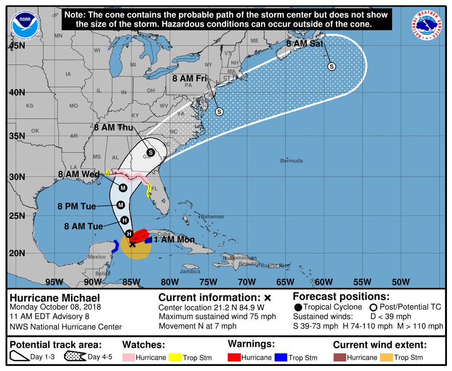
As for now, Michael is forecast to reach Category 2 hurricane strength with winds of 96-110 mph. But it could reach Category 3 hurricane strength with winds of 111-120 mph, according to AccuWeather.
The center of storm could come to South Jersey or it could move offshore into the Atlantic Ocean, according to Sarah Johnson of the National Weather Service. Either way, she said, New Jersey is expected to get a lot of rain from this system, especially on Friday.
And even if the storm moves offshore, the northern part of the system is expected to impact New Jersey with heavy rain, Johnson said.
"Right now, there is still a lot of uncertainty about this storm," she told Patch.

Here is the forecast:
- Columbus Day: A slight chance of showers between 2pm and 3pm. Cloudy, with a high near 72. East wind around 8 mph. Chance of precipitation is 20%.
- Monday night: Areas of fog after 2am. Otherwise, mostly cloudy, with a low around 65. East wind 3 to 6 mph.
- Tuesday: Patchy fog between 8am and 11am. Otherwise, partly sunny, with a high near 80. South wind 3 to 7 mph.
- Tuesday night: Mostly cloudy, with a low around 65. South wind around 7 mph.
- Wednesday: A chance of showers, mainly after 2pm. Partly sunny, with a high near 79. South wind 5 to 9 mph. Chance of precipitation is 30%.
- Wednesday night: A chance of showers. Mostly cloudy, with a low around 68. Chance of precipitation is 40%. New precipitation amounts of less than a tenth of an inch possible.
- Thursday: Showers. High near 78. Chance of precipitation is 80%.
- Thursday night: Showers. Low around 60. Chance of precipitation is 80%.
- Friday: Showers likely, mainly before 8am. Partly sunny, with a high near 66. Chance of precipitation is 60%.
- Friday night: A chance of showers before 2am. Partly cloudy, with a low around 48. Chance of precipitation is 30%
Tom Davis photo
Get more local news delivered straight to your inbox. Sign up for free Patch newsletters and alerts.