Weather
NJ Weather: Possible Strong Storms, 45-MPH Winds In Forecast
A hazardous weather outlook has been issued. Find out when this is all supposed to hit.


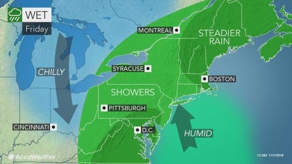
Potentially strong storms are expected to hit New Jersey on Friday and Saturday – with winds possibly gusting up to 45 mph. The Weather Channel and AccuWeather say a tornado is even possible.
The National Weather Service has issued a hazardous weather outlook for New Jersey, saying rain – mainly Friday night – could be heavy enough to result in localized flooding.
A total of 1-2 inches of rain should fall, but up to 3 inches is possible. Winds on Saturday are expected to gust to 35-45 mph.
Find out what's happening in Point Pleasantfor free with the latest updates from Patch.

The Weather Channel says there is some chance that strong to severe thunderstorms will spread toward the East Coast into Friday night, from southwestern New England to central Florida.
Damaging wind gusts and a tornado or two are possible with any storms that develop. The Weather Channel even put South Jersey in its Tornado Risk Area for November.
Find out what's happening in Point Pleasantfor free with the latest updates from Patch.
Sporadic power outages and tree damage may result, AccuWeather said. AccuWeather also said there could be an isolated tornado.
Indeed, back-to-back storms aiming at the Northeast, beginning Friday, could prevent the dry and mild weather that started November from south of Boston to New York City and Washington, D.C., from lasting, according to AccuWeather.
After some rain will fall on Friday, AccuWeather said soaking rain will spread from southwest to northeast along the Interstate 95 corridor from Friday afternoon into Saturday morning.
"This fast-strengthening storm will bring a range of impacts and likely lead to travel delays across the Northeast," AccuWeather Meteorologist Bill Deger said in a release.
Totals between the two bouts of rain will generally be 1-2 inches with locally higher amounts.
Motorists will have to use caution as the heavy rain can lead to reduced visibility and a heightened risk of vehicles hydroplaning when traveling at highway speeds. Leaf-covered roads can turn slippery when wet, according to the release. The drenching rain may be accompanied by gusty winds and thunderstorms in some communities.
"While widespread severe weather is not expected, it is not out of the question some showers or thunderstorms could bring brief, strong wind gusts to the mid-Atlantic on Friday night and central and southern New England on Saturday," Deger said in the release.
Here is the forecast:
- Friday: A chance of showers, with thunderstorms also possible after noon. Cloudy, with a high near 71. Southwest wind 13 to 15 mph, with gusts as high as 30 mph. Chance of precipitation is 50%. New rainfall amounts between a tenth and quarter of an inch, except higher amounts possible in thunderstorms.
- Friday night: Rain and thunderstorms likely before 8pm, then rain and possibly a thunderstorm between 8pm and 2am, then showers after 2am. Some of the storms could produce heavy rain. Low around 55. South wind 9 to 11 mph, with gusts as high as 25 mph. Chance of precipitation is 100%. New rainfall amounts between 1 and 2 inches possible.
- Saturday: Showers likely, mainly before 11am. Cloudy through mid morning, then gradual clearing, with a high near 58. Breezy, with a west wind 10 to 15 mph increasing to 20 to 25 mph in the afternoon. Winds could gust as high as 44 mph. Chance of precipitation is 60%. New precipitation amounts between a tenth and quarter of an inch possible.
- Saturday night: Mostly clear, with a low around 38. Northwest wind 5 to 11 mph.
Tom Davis photo
Get more local news delivered straight to your inbox. Sign up for free Patch newsletters and alerts.


