Weather
NJ Weather: Storms – And Even Snow – In Forecast; Send The Plows?
Will New Jersey call out the salt and brine trucks – just like the state did earlier in the week?


New Jersey may just have to call out the salt trucks for this system since the state could get some of the roughest weather its had in weeks.
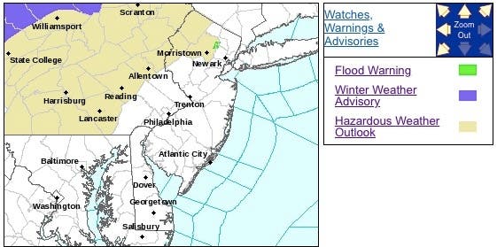
The National Weather Service has issued a hazardous weather outlook for parts of New Jersey since storms – and even some snow – are expected to arrived on Friday and Saturday.
The NWS says there is the potential for a period of a wintry mix late Saturday afternoon into Saturday evening in North Jersey, mainly for the higher elevations, which could include sleet and freezing rain. This could lead to hazardous travel conditions due to icy spots on untreated surfaces.
Find out what's happening in Point Pleasantfor free with the latest updates from Patch.
Here are the alerted areas:
State Department of Transportation trucks treated many New Jersey roads on Wednesday since state officials, who took a lot of heat for their lackluster response during a recent nor'easter, said snow was forecasted in six counties.
Find out what's happening in Point Pleasantfor free with the latest updates from Patch.
Forecasters, however, were heckling the state because the National Weather Service only predicted a very light dusting in Sussex County on that day. No other rain – freezing or otherwise – was predicted in the state.
Read more: NJ Got Big-Time Ready For Snow – Even Though It Barely Snowed
This time, the NWS says spotty areas of a light wintry mix is possible on Friday. Little, if any, accumulations is expected.
But a wintry mix could arrived in North Jersey by late Friday, making roads slippery and hazardous.
-1543589227-7591.jpg)
The main storm will spread rain across the eastern part of the Ohio Valley, central Appalachians, eastern Great Lakes and New Jersey and Pennsylvania during Saturday, according to AccuWeather.
"As the mild, moist air flows northward, the cold ground can lead to widespread fog," AccuWeather Senior Meteorologist Dave Dombek said in a release.
Some of that fog can be dense enough to slow travel on the highways and lead to airline delays.
"The fog may cause the most trouble where there is snow on the ground or near a source of extra moisture, such as the Atlantic coast," Dombek said in the release.
Even though the storm is forecast to make steady, sweeping progress across the region, enough rain may fall to cause flooding in poor drainage areas. This issue may be most common where there has been recent heavy snowfall or where large piles of snow are blocking storm drains around the Great Lakes and in northern New England, according to AccuWeather.
-1543589410-519.jpg)
Here is the forecast:
- Friday: A chance of rain – and snow in North Jersey – before 1pm, then a chance of rain between 1pm and 3pm, then a chance of rain and snow after 3pm. Cloudy, with a high near 37. Light southwest wind. Chance of precipitation is 30%. Little or no snow accumulation expected.
- Friday night: A slight chance of rain – and snow in North Jersey – before 8pm. Cloudy, then gradually becoming partly cloudy, with a low around 28. Calm wind becoming northwest around 5 mph after midnight. Chance of precipitation is 20%.
- Saturday: A chance of rain, mainly after 4pm. Increasing clouds, with a high near 41. Light and variable wind becoming east around 5 mph in the afternoon. Chance of precipitation is 40%. New precipitation amounts of less than a tenth of an inch possible.
- Saturday night: Rain, mainly after 7pm. Low around 34. East wind around 9 mph. Chance of precipitation is 100%. New precipitation amounts between a half and three quarters of an inch possible.
- Sunday: Rain likely, mainly before 1pm. Cloudy, with a high near 58. Southeast wind around 7 mph becoming southwest in the afternoon. Chance of precipitation is 70%. New precipitation amounts between a tenth and quarter of an inch possible.
Tom Davis photos
Get more local news delivered straight to your inbox. Sign up for free Patch newsletters and alerts.


