Weather
NJ Weather: Storms In Labor Day Weekend Forecast: What To Expect
Here's what to expect during the last unofficial weekend of the summer.


If you think you're finally going get that one completely beautiful summer weekend in New Jersey, forget about it. But it shouldn't be as bad as other weekends that have made this season nearly a washout.
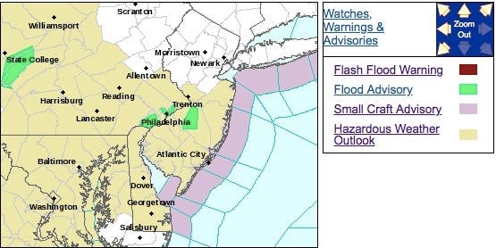
A hazardous weather outlook is in effect for much of the state, with some showers and thunderstorms on Friday capable of producing very heavy downpours. The storms could lead to localized flooding, especially in poor drainage areas.
After that, more thunderstorms are possible, but the chances diminish on Saturday, Sunday and Monday. (see forecast below).
Find out what's happening in Point Pleasantfor free with the latest updates from Patch.
Here are the alerted areas:
AccuWeather says New Jersey and Pennsylvania will have to dodge showers and thunderstorms in between cookouts, camping trips and other Labor Day weekend activities.
Find out what's happening in Point Pleasantfor free with the latest updates from Patch.
AccuWeather Senior Meteorologist Carl Babinski expects a completely dry day to be hard to come by from Saturday to Monday (Labor Day).
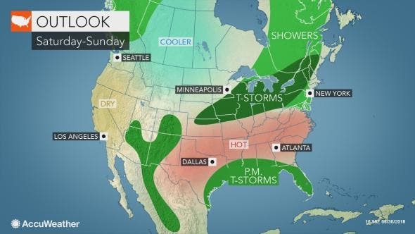
The storms are likely to be most active in Virginia, Maryland, Delaware, Pennsylvania and New Jersey, according to an AccuWeather release. While some sunshine is expected on Monday, Babinski anticipates showers and thunderstorms to develop, especially over interior locales.
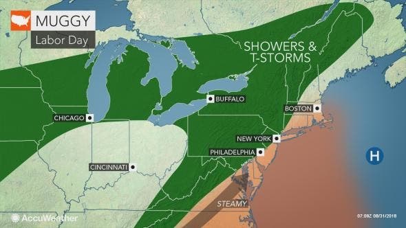
The storms throughout Labor Day weekend will be hit-or-miss in nature, soaking some communities but missing others just a few miles away, according to AccuWeather. Although Labor Day marks the unofficial end of summer, the season’s heat and humidity may have some staying power in the Northeast for much of next week.
"Any tropical depressions, storms or hurricanes that develop near the Bahamas or in the Gulf of Mexico could pump heat and humidity farther to the north over the U.S. next week," said AccuWeather Senior Meteorologist Alex Sosnowski said in the release.
Here is the forecast:
- Friday: Scattered showers and thunderstorms before noon, then showers likely and possibly a thunderstorm between noon and 3pm, then scattered showers and thunderstorms after 3pm. Some of the storms could produce heavy rainfall. Cloudy, with a high near 78. East wind 10 to 13 mph. Chance of precipitation is 60%. New rainfall amounts between a quarter and half of an inch possible.
- Friday night: A chance of showers, mainly after midnight. Cloudy, with a low around 68. East wind 6 to 8 mph. Chance of precipitation is 30%. New precipitation amounts of less than a tenth of an inch possible.
- Saturday: A chance of showers and thunderstorms. Mostly cloudy, with a high near 80. East wind around 8 mph. Chance of precipitation is 30%.
- Saturday night: A chance of showers and thunderstorms before 8pm, then a slight chance of showers. Mostly cloudy, with a low around 69. East wind around 6 mph becoming calm in the evening. Chance of precipitation is 30%.
- Sunday:; A chance of showers and thunderstorms. Partly sunny, with a high near 85. Calm wind becoming south around 5 mph in the afternoon. Chance of precipitation is 30%. New rainfall amounts of less than a tenth of an inch, except higher amounts possible in thunderstorms.
- Sunday night: A chance of showers and thunderstorms before 8pm, then a slight chance of showers. Mostly cloudy, with a low around 70. Chance of precipitation is 30%. New precipitation amounts of less than a tenth of an inch, except higher amounts possible in thunderstorms.
- Labor Day: A chance of showers, with thunderstorms also possible after 2pm. Partly sunny, with a high near 88. Chance of precipitation is 30%.
- Monday Night: A chance of thunderstorms before 8pm. Partly cloudy, with a low around 71. Chance of precipitation is 30%.
Tom Davis photos
Get more local news delivered straight to your inbox. Sign up for free Patch newsletters and alerts.