Weather
NJ Weather: Timeline For Thunderstorms, Flash Flood Watch
Accidents are already tying up roadways as Wednesday could be the worst weather day of the week for New Jersey. Find out where and when.

An inch of rain could fall per hour and present a risk to New Jersey commuters on what's supposed to be the worst weather day of the week. Accidents were already tying up roadways in New Jersey as the forecast is supposed to get even more bleak.
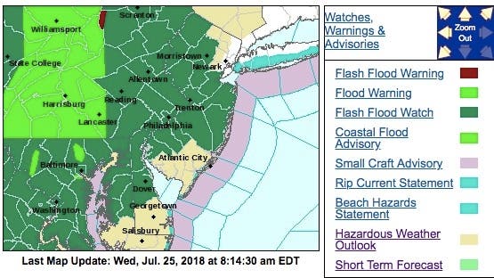
The National Weather Service has issued a hazardous weather outlook and a flash flood watch for nearly the entire state, saying showers and scattered thunderstorms will develop Wednesday and continue into tonight. Winds could also be "damaging."
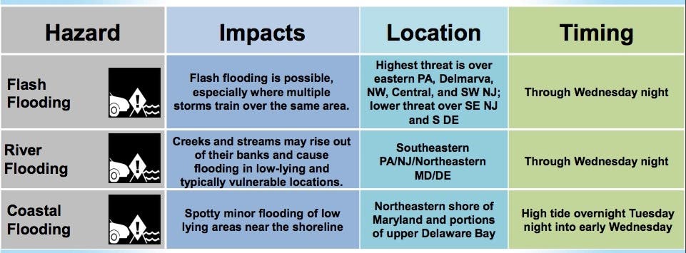
A "tropical airmass" will support areas of heavy rain, especially if there are showers and thunderstorms over the same area. Rainfall amounts over 1 inch in an hour are possible, according to the National Weather Service.
Find out what's happening in Point Pleasantfor free with the latest updates from Patch.
Excessive rainfall within a short period of time can lead to rapidly rising water and flash flooding, particularly in urban areas and along small creeks and streams.
Here are the alerted areas:
Find out what's happening in Point Pleasantfor free with the latest updates from Patch.
Throughout New Jersey, showers will continue to move northward across the region and downpours may create localized ponding on roadways.
Here is how the National Weather Service has broken down the day:
Here are some other main points:
- The worst of the rain is supposed to hit in Somerset, Hunterdon and Sussex counties, but all areas of New Jersey will be impacted.
- The worst of the rain is supposed to happen before 1 p.m. in all areas. The rain is supposed to pick up again after 7 p.m.
- Thunder and lightning could be a threat in all areas all day long.
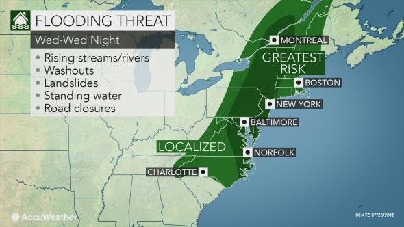
- Through Wednesday, showers and storms will be most numerous over eastern Pennsylvania, Delmarva, and areas along and west of the I-95 urban corridor including central and northern New Jersey leading to a higher flood threat and a more limited flood threat in southeastern New Jersey.
- Minor coastal flooding is possible in spots around the time of high tide early Wednesday along the eastern shore of Maryland and upper Delaware Bay due to a persistent southerly flow.
- Any heavier storms through late Wednesday could produce isolated damaging winds.
Already, the weather may be impacting the roads. Here were the accidents reported as of 9 a.m.:
- I-78: Accident on I-78 express lanes westbound West of Exit 54 - Winans Ave/Paine Ave in Hillside Twp. Left lane closed 10-15 minute delay.
- Whitesville Road: Accident on Whitesville Road southbound between South Hope Chapel Road and Faraday Avenue in Jackson Twp. All lanes closed 1 lane open northbound. Please avoid area and use alternate routes.
- Garden State Parkway: Accident with injuries on the Garden State Parkway southbound Exit 148 - John F Kennedy Dr North in Bloomfield. Left lane blocked.
- Garden State Parkway: Accident on the Garden State Parkway northbound exiting at Exit 131 -A - Wood Avenue South in Woodbridge Twp. Right shoulder blocked.
- Garden State Parkway: Accident on the Garden State Parkway southbound South of Exit 145 - I-280 in East Orange. Right shoulder blocked.
Here is the forecast:
- Wednesday: Showers and possibly a thunderstorm. Some of the storms could produce heavy rain. High near 79. South wind around 10 mph. Chance of precipitation is 80%. New rainfall amounts between a tenth and quarter of an inch, except higher amounts possible in thunderstorms.
- Wednesday night: Showers and possibly a thunderstorm. Some of the storms could produce heavy rain. Patchy fog after 2am. Low around 70. South wind 6 to 8 mph. Chance of precipitation is 90%. New rainfall amounts between a tenth and quarter of an inch, except higher amounts possible in thunderstorms.
- Thursday: Showers likely and possibly a thunderstorm before 8am, then a chance of showers and thunderstorms between 8am and 3pm, then a chance of showers after 3pm. Patchy fog before 9am. Otherwise, cloudy, with a high near 83. Southwest wind around 6 mph. Chance of precipitation is 60%. New rainfall amounts between a tenth and quarter of an inch, except higher amounts possible in thunderstorms.
- Thursday night: A chance of showers, mainly before 9pm. Mostly cloudy, with a low around 71. Southwest wind 5 to 7 mph. Chance of precipitation is 40%. New precipitation amounts of less than a tenth of an inch possible.
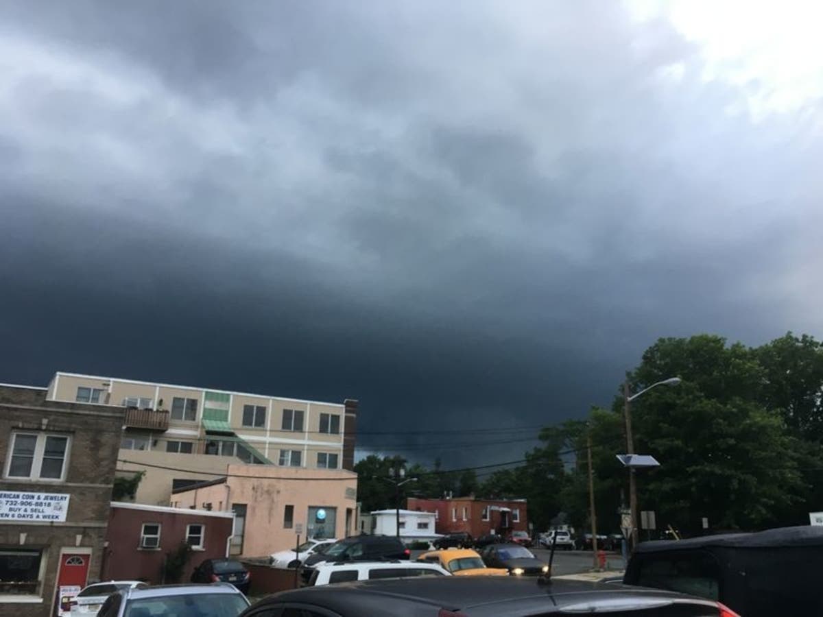
Tom Davis photo
Get more local news delivered straight to your inbox. Sign up for free Patch newsletters and alerts.


