Weather
NJ Weather: Timeline For Weekend Storms; Is Tornado Possible?
The storm could "resemble a nor'easter," with a watersport possible, forecasters say. Flooding was already happening Saturday.


Persistent rain was disrupting travel and hindering outdoor plans on Saturday, and it's expected to last until Sunday. A tornado and a waterspout were also possible, and "life-threatening" rip currents were impacting the beaches.
Flooding was also happening in certain parts of the state, such as Wildwood, Sea Isle City and Avalon. The George Redding Bridge was closed because of flooding.
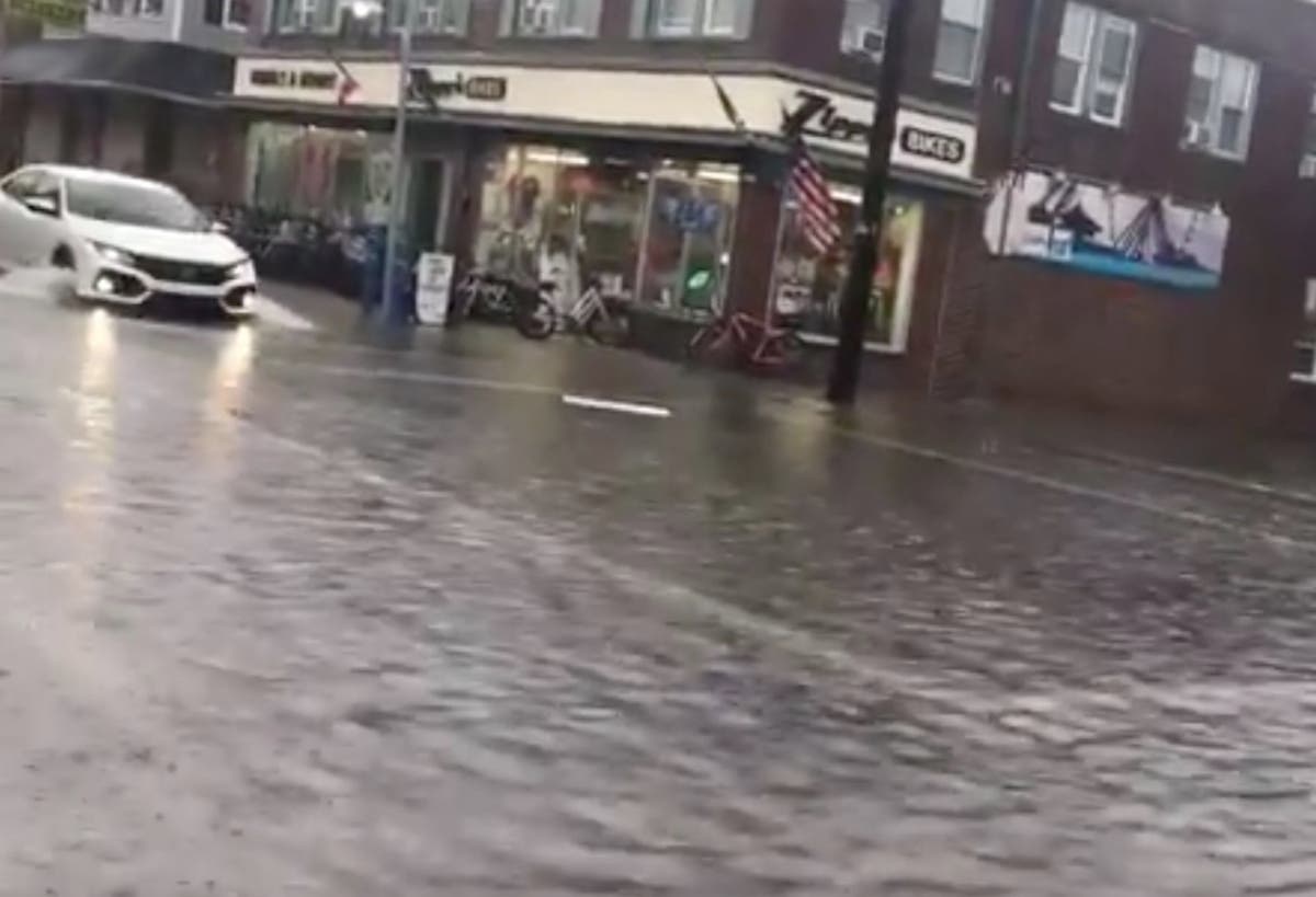
#FirstAlert Weather Update in Wildwood, NJ ☔️ Pacific Ave & Spicer #IThinkWereGonnaNeedABiggerBoat @NBCPhiladelphia @6abc @weatherchannel @HurricaneNBC10 @FOX29philly @phl17 pic.twitter.com/Cpj62047Lg
— Philly Sports Digest (@PhSportsDigest) July 21, 2018
Some moderate flooding along Ocean Drive in Avalon. pic.twitter.com/GWnpfsSuRK
— Ann Delaney (@AnnDelaneyBeach) July 21, 2018
Flooding in #seaislecity, #nj. @6abc pic.twitter.com/f2LdA73xA0
— Ryan Lingo (@ryanclingo) July 21, 2018
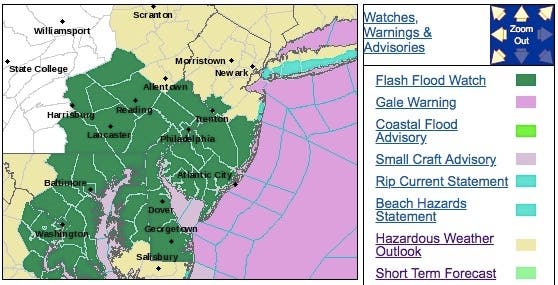
The National Weather Service says a flash flood watch was in effect for parts of New Jersey, while a hazardous weather outlook is in effect for the entire state. Wind gusts could approach 60 mph along the coast. A wind advisory was also in effect.
Find out what's happening in Point Pleasantfor free with the latest updates from Patch.
~In addition to the heavy rain and isolated tornado threat in NJ tomorrow, strong winds will also be the case! Winds will gust 35-45mph, occasional gusts reaching 50mph+ for the coast and in embedded thunderstorms. pic.twitter.com/0vDQzYTEu5
— BLIZZARD Bronsky(@NJoutdoors11) July 20, 2018
The combination of rain and breezy conditions may seem more like a nor'easter from the spring or autumn in places such as Norfolk, Virginia; Ocean City, Maryland; Atlantic City, New Jersey; New York City and Boston, according to AccuWeather.
Here are alerted areas:
Find out what's happening in Point Pleasantfor free with the latest updates from Patch.
Here is what also to expect:
- Heavy rain is expected from this afternoon into this evening.
- Rainfall amounts of 2 to 4 inches are forecast. Much of the rain is expected to fall over a period of only a few hours.
- Excessive rainfall in a short amount of time can lead to flash flooding. Urban areas, locations along small streams and creeks, and areas of poor drainage are most vulnerable to flash flooding.
- Breaking waves will build to 3 to 6 feet in the surf zone, causing very strong rip currents that will be life- threatening to anyone who enters the surf.
Forecasters say to watch for possible tornadoes and waterspouts Saturday evening and Sunday:
I would bet the house that there will be waterspouts and potentially weak tornadoes along the NJ Coast tomorrow afternoon and evening. Tremendous amount of low level shear and a tongue of instability with tropical moisture. #njwx pic.twitter.com/KXTbqj209A
— John Homenuk (@jhomenuk) July 20, 2018
While our coastal hybrid begins to take shape, we may have to watch for the potential for a tornado or two along the NJ/DE coast tomorrow evening. Hi-res models have been hinting at a line of thunderstorms moving in with impressive dynamics aloft #njwx #nywx pic.twitter.com/gw3sEgCzOF
— Steve Copertino (@TheSteveCop) July 20, 2018
Streams and creeks could leave their banks, flooding nearby properties. Please monitor the forecast, especially if you live in a location that is prone to flooding. Be prepared to take action if a flash flood warning is issued for your area, according to the National Weather Service.
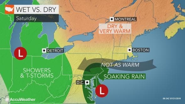
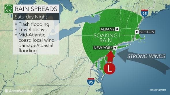
The storm will force drenching rain northward along the mid-Atlantic coast and into New England this weekend, according to AccuWeather.
The combination of drenching rain and gusty winds could cause sporadic power outages, especially where strong thunderstorms become intertwined with the storm system, according to AccuWeather.
Here is the forecast:
- Saturday: Showers likely, mainly after 3pm. Increasing clouds, with a high near 75. Breezy, with an east wind 14 to 19 mph increasing to 20 to 25 mph in the afternoon. Winds could gust as high as 36 mph. Chance of precipitation is 60%. New precipitation amounts between a tenth and quarter of an inch possible.
- Saturday night: Showers and possibly a thunderstorm before 3am, then showers likely. Low around 69. Windy, with an east wind 24 to 33 mph becoming south after midnight. Winds could gust as high as 47 mph. Chance of precipitation is 90%. New rainfall amounts between 1 and 2 inches possible.
- Sunday: Showers likely, with thunderstorms also possible after 8am. Mostly cloudy, with a high near 80. South wind 13 to 16 mph. Chance of precipitation is 60%. New rainfall amounts between a tenth and quarter of an inch, except higher amounts possible in thunderstorms.
- Sunday night: Showers likely and possibly a thunderstorm. Cloudy, with a low around 74. South wind around 14 mph. Chance of precipitation is 60%. New rainfall amounts between a quarter and half of an inch possible.
Photo courtesy of Philly Sports Digest @PhSportsDigest
Get more local news delivered straight to your inbox. Sign up for free Patch newsletters and alerts.


